
Detroit Lake is a reservoir impounded by the Detroit Dam on the North Santiam River 46 miles (74 km) southeast of Salem, Oregon, United States. The lake is adjacent to Oregon Route 22 near the city of Detroit. This mesotrophic lake stores water for use by the city of Salem and other nearby communities.

Bad Arolsen is a small town in northern Hesse, Germany, in Waldeck-Frankenberg district. From 1655 until 1918 it served as the residence town of the Princes of Waldeck-Pyrmont and then until 1929 as the capital of the Waldeck Free State. The International Tracing Service has its headquarters in Bad Arolsen. In 2003, the town hosted the 43rd Hessentag state festival.

Waldeck is a small town in Waldeck-Frankenberg district in northwestern Hesse, Germany.

The Sihl is a Swiss river that rises near the Druesberg mountain in the canton of Schwyz, and eventually flows into the Limmat in the centre of the city of Zürich. It has a length of 73 km (45 mi), including the Sihlsee reservoir, through which the river flows. Water is abstracted from the river at the Sihlsee, leading to decreased downstream water flows and a consequent reduction in water quality.

Twistetal is a community in Waldeck-Frankenberg in northwest Hesse, Germany, southwest of Bad Arolsen.
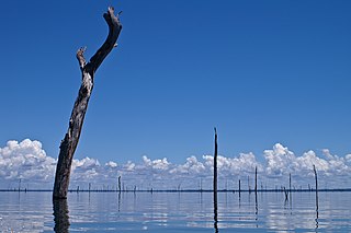
The Brokopondo Reservoir, officially named Professor Doctor Ingenieur W. J. van Blommestein Meer, and also called the Brokopondostuwmeer, is a large reservoir in Suriname. It is named after the Surakarta-born Dutch hydrological engineer Willem Johan van Blommestein. With a surface area of approximately 1,560 km2 (600 sq mi), depending on the current water level, it is one of the largest reservoirs in the world, flooding nearly one percent of the country.
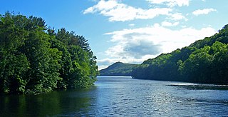
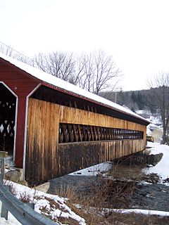
East Branch Reservoir, is a reservoir in the town of Southeast, New York, near the village of Brewster. Part of the New York City water supply system, it was formed by impounding the East Branch of the Croton River. Forming part of the Croton Watershed, it was placed into service in 1891, and lies some 35 miles (56 km) north of the city, in the southeast corner of Putnam County.

Welda is a village and constituent community (stadtteil) of the town of Warburg, in the district of Höxter in the east of the federal state of North Rhine-Westphalia, Germany. Welda has historically been known by the names of Wellede, Welde and Kerkwellede.
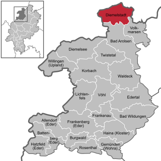
Diemelstadt is a small town in Waldeck-Frankenberg district in Hesse, Germany.

Diemelsee is a municipality in Waldeck-Frankenberg in northwest Hesse, Germany, and is part of the low mountain region called Upland. Adorf is the district seat of this municipality.

The Saugatuck Reservoir is a reservoir in Fairfield County, Connecticut, United States, that straddles the border between the towns of Redding, Weston, and Easton. Its completion is marked by the creation of the Samuel P. Senior dam of the Saugatuck River in January 1942, and provides water to several of the nearby towns. The reservoir is surrounded by the Centennial Watershed State Forest and a small section of the Trout Brook Valley State Park Reserve on the southeast end of the reservoir. The Saugatuck Reservoir utilizes an uncontrolled spillway adjacent to the Samuel P. Senior dam that effectively limits the maximum water level. There is also a concrete levee positioned on the southeastern side of the reservoir that prevents water from flooding Trout Brook Valley.
The Ware River is a 35.4-mile-long (57.0 km) river in central Massachusetts. It has two forks, the both of which begin in Hubbardston, Massachusetts. The Ware River flows southwest through the middle of the state, joins the Quaboag River at Three Rivers, Massachusetts, to form the Chicopee River on its way to the Connecticut River.

The Kali River or Kali nadi is a river flowing through Uttara Kannada district of Karnataka state in India. The river rises near Kushavali, a small village in Uttar Kannada district. The river is the lifeline to some 400,000 people in the Uttara Kannada district and supports the livelihoods of tens of thousands of people including fishermen on the coast of Karwar. There are many dams built across this river for the generation of electricity. One of the important dams build across Kali river is the Supa Dam at Ganeshgudi. The river runs 184 kilometers before joining Arabian Sea.

West Hill Dam Reserve is a United States Army Corps of Engineers flood control project with a recreational park and wildlife management area located at Uxbridge, Massachusetts. The West Hill Dam Project was completed in 1960. It is located on the West River, one of the branches of the Blackstone River which flows from Worcester, MA to Providence, RI. The West River originates in Grafton, Massachusetts, at Cider Mill Pond and Silver Lake, near Upton, Massachusetts, and the Upton State Forest. The dam is unusual in that it isn't filled unless there is a flood. West Hill Dam was built after devastating floods during the 1950s; it is intended to protect the Blackstone Valley from future destructive flooding. The cities and towns downriver from Uxbridge, including Millville, Blackstone, Woonsocket, North Smithfield, Cumberland, Lincoln, Central Falls, Pawtucket and Providence, Rhode Island, suffered extensive flooding from the Blackstone during Hurricane Diane in 1955. Hurricane Donna tested this new dam in 1960 as the eyewall passed over. The West Hill Dam is located in the Blackstone River Valley National Heritage Corridor near the Blackstone River and Canal Heritage State Park. Park rangers provide visitor assistance and offer scheduled interpretative programs. Fishing, hunting, and wildlife viewing opportunities are available year-round. The park has a recreation area, 34 picnic sites, one playground, a swimming area and five miles of hiking trails. However, access to the park from West Hill Road is currently blocked as of 2021 because of landowner disagreements. West Hill Dam is also the field office for the Charles River Natural Valley Storage Area. It consists of scattered wetlands in the upper and middle Charles River watershed, between the towns of Bellingham and Needham. The wetlands provide flood storage area, fisheries, wildlife management, and recreation. The Charles River is the well-known watercourse that flows into Boston Harbor.

Sylvenstein Dam is an earthen embankment dam in the Isar valley, in the alpine part of Upper Bavaria, Germany which impounds the Sylvenstein Reservoir.

Saville Dam is an earthen embankment dam with masonry work on the eastern branch of the Farmington River in southwestern Barkhamsted, Connecticut. The dam is 135 ft. tall and 1,950 ft. long and has an uncontrolled spillway on its western portion. It creates the Barkhamsted Reservoir which has a volume of 36.8 billion US gallons (139,000,000 m3) and is the primary water source for Hartford, Connecticut.
The Waldeck Plateau is a natural 'upper main unit' in the German state of Hesse between the rivers Eder and Diemel, the East Sauerland Hills in the west and the East Waldeck Basin in the east.
Otto III, Count of Waldeck-Landau was the second ruling count of the elder Waldeck-Landau line, which had started. He was the son of Count Adolph III, who had founded the elder Waldeck-Landau in 1397, and his wife, Agnes of Ziegenhain.
The Steina Dam in the Harz Mountains of central Germany is a dam system comprising a dam, reservoir and waterworks near the village of Steina and belongs to the unincorporated area of Harz in the county of Osterode am Harz in Lower Saxony.
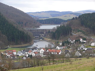
The Diemelsee or Diemel Reservoir is a reservoir with a surface area of 1.65 km² and about capacity of 19.9 million m³ on the River Diemel in the counties of Waldeck-Frankenberg in North Hesse, and Hochsauerlandkreis, Westphalia, Germany.

