The Allegheny River is a 325-mile (523 km) long headwater stream of the Ohio River in western Pennsylvania and New York, United States. The Allegheny River runs from its headwaters just below the middle of Pennsylvania's northern border northwesterly into New York then in a zigzag southwesterly across the border and through Western Pennsylvania to join the Monongahela River at the Forks of the Ohio on the "Point" of Point State Park in Downtown Pittsburgh, Pennsylvania. The Allegheny River is, by volume, the main headstream of both the Ohio and Mississippi Rivers. Historically, the Allegheny was considered to be the upper Ohio River by both Native Americans and European settlers.

The University of Fort Hare is a public university in Alice, Eastern Cape, South Africa.
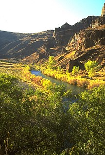
The Owyhee River is a tributary of the Snake River located in northern Nevada, southwestern Idaho and southeastern Oregon in the United States. It is 280 miles (450 km) long. The river's drainage basin is 11,049 square miles (28,620 km2) in area, one of the largest subbasins of the Columbia Basin. The mean annual discharge is 995 cubic feet per second (28.2 m3/s), with a maximum of 50,000 cu ft/s (1,400 m3/s) recorded in 1993 and a minimum of 42 cu ft/s (1.2 m3/s) in 1954.

The Sevier River is a 385-mile (620 km)-long river in the Great Basin of southwestern Utah in the United States. Originating west of Bryce Canyon National Park, the river flows north through a chain of high farming valleys and steep canyons along the west side of the Sevier Plateau, before turning southwest and terminating in the endorheic basin of Sevier Lake in the Sevier Desert. It is used extensively for irrigation along its course, with the consequence that Sevier Lake is usually dry.

Lovedale also known as Lovedale Missionary Institute was a mission station and educational institute in the Victoria East division of the Cape Province, South Africa. It lies 520 metres (1,720 ft) above sea level on the banks of the Tyhume River, a tributary of the Keiskamma River, some 3.2 kilometres (2 mi) north of Alice.

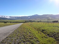
Alice is a small town in South Africa that is named after The Princess Alice, daughter of the British Queen Victoria. Settled in 1824 by British colonists adjacent to the Tyhume River.

Loubet Coast is the portion of the west coast of Graham Land in Antarctic Peninsula, extending 158 km between Cape Bellue to the northeast and Bourgeois Fjord to the southwest. South of Loubet Coast is Fallières Coast, north is Graham Coast.

The Gariep Dam is located in South Africa, near the town of Norvalspont, bordering the Free State and Eastern Cape provinces. Its primary purpose is for irrigation, domestic and industrial use as well as for power generation.

Clanwilliam is a town in the Olifants River valley in the Western Cape, South Africa, about 200 kilometres (120 mi) north of Cape Town. It is located in, and the seat of, the Cederberg Local Municipality. As of 2011 Clanwilliam had a population of 7,674.
William Wellington Gqoba was a South African Xhosa poet, translator, and journalist. He was a major nineteenth-century Xhosa writer, whose relatively short life saw him working as a wagonmaker, a clerk, a teacher, a translator of Xhosa and English, and a pastor.

A national mapping agency is an organisation, usually publicly owned, that produces topographic maps and geographic information of a country. Some national mapping agencies also deal with cadastral matters.

Wemmershoek Dam is an rock-fill type dam located on the Wemmershoek River near Franschhoek and Paarl in South Africa. It was constructed between 1953 and 1957 on behalf of the City of Cape Town. With a reservoir capacity of 58,644 megalitres, it provides approximately 6.5% of the storage capacity of the Western Cape Water Supply System which supplies Cape Town and surrounding areas.

Woodhead Dam is a dam on Table Mountain, Western Cape, South Africa. It was built in 1897 and supplies water to Cape Town. The dam, which was the first large masonry dam in South Africa, was designated as an International Historic Civil Engineering Landmark by the American Society of Civil Engineers in 2008.
Salmonsdam Nature Reserve is a nature reserve in the Overberg region of the Western Cape province of South Africa. It contains the mountain catchment area of the Paardensberg River in the Akkedisberg mountains. The reserve is administered by CapeNature and covers an area of 834 hectares.
Binfield Park Dam is a dam on the Tyhume River, near Alice, Eastern Cape, South Africa. It was established in 1986, and commissioned in 1987.

Molteno Dam is a small but historic dam, on the lower slopes of Table Mountain in Western Cape, South Africa. Still in service, it was established in 1877 and is now located in the suburb of Oranjezicht, Cape Town.

Graham Coast is the portion of the west coast of Graham Land in Antarctic Peninsula, extending 172 km between Cape Bellue to the southwest and Cape Renard to the northeast.

Survey of Pakistan is the sole national mapping and land surveying government agency of Pakistan. Its head of department is titles as "Surveyor General of Pakistan".

The Keiskamma River is a river in the Eastern Cape Province in South Africa. The river flows into the Indian Ocean in the Keiskamma Estuary, located by Hamburg Nature Reserve, near Hamburg, midway between East London and Port Alfred. The Keiskamma flows first in a southwestern and then in a southeastern direction after meeting its main tributary, the Tyhume River.

Ngonyezi Pumped Hydroelectric Energy Storage Power Station, also Ngonyezi Power Station, is a planned 2,000 megawatt-hours (7,200 GJ) hydroelectric power station, across the Odzi River, a tributary of the Save River, in Zimbabwe. The power station is under development by Ngonyezi Projects Limited (NPL), a company based in Pretoria, South Africa. NPL will also build a floating solar farm on the existing Osborne Dam reservoir with capacity of 300 megawatts. On sunny days, the solar farm will supply energy to the grid directly. When the sun goes down or on cloudy/rainy days or during peak hours, the stored water in the upper reservoir will be turned on to produce hydroelectric power by turning turbines, as it flows to the lower reservoir. After the upper reservoir is empty, the solar farm will provide energy to pump the water back into the upper reservoir and begin the cycle once gain.