
Mtamvuna River is a river that forms the border between KwaZulu-Natal and the Eastern Cape Provinces in South Africa. The river has a wide mouth and flows into the Indian Ocean just south of Port Edward. The Mtamvuna river is approximately 162 km long with a catchment area of 1,553 km². The name means "the reaper of mouthfuls" because of the damage the river does to crops during floods.

The Great Fish River is a river running 644 kilometres (400 mi) through the South African province of the Eastern Cape. The coastal area between Port Elizabeth and the Fish River mouth is known as the Sunshine Coast. The Great Fish River was originally named Rio do Infante, after João Infante, the captain of one of the caravels of Bartolomeu Dias. Infante visited the river in the late 1480s.

The Mzimkulu River is a river in South Africa. In the past, the Mzimkulu formed part of the border between Eastern Cape and KwaZulu-Natal provinces. Presently this river is part of the Mvoti to Umzimkulu Water Management Area. In late February of every year, the river is host to one of South Africa's most popular canoe races, the Drak Challenge.
The Nahoon River is situated in the city of East London on the east coast of South Africa.
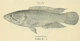
The Eastern Province rocky, also known as rocky kurper, is a species of fish in the family Anabantidae. It is endemic to South Africa.

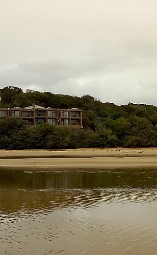
The Buffalo River is situated in the city of East London on the East Coast of South Africa. It is to the west of the Nahoon River. It is the only navigable river in South Africa. The town of East London was thus established around it.
Mzimvubu to Keiskamma WMA, or Mzimvubu to Keiskamma Water Management Area , includes the following major rivers: the Swane River, Mntafufu River, Mzimvubu River, Mngazi River, Mthatha River, Xora River, Mbashe River, Nqabara River, Gqunube River, Buffalo River, Nahoon River, Groot Kei River and Keiskamma River, and covers the following Dams:

The Kowie River is a river in the Eastern Cape, South Africa. It has its source in the hills of the "Grahamstown Heights" from where it flows in a south-easterly direction draining the major part of the Bathurst region, reaching the Indian Ocean through an estuary at Port Alfred.
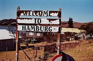
Hamburg is a small town with about 1000 inhabitants in the Eastern Cape province, in South Africa. It is located on the coast between the city of East London and the town of Port Alfred.

Palmiet River is a river located in the Western Cape province of South Africa. The Palmiet River is a typical Western Cape river, experiencing winter rainfall and it is important for the Western Cape Water Supply System. It has a small catchment area of 500 km2, flows through the expanse of the Elgin Valley, and reaches the ocean through an estuary.

Mthatha River or Umtata River is a river in the Eastern Cape Province in South Africa. The river flows into the Indian Ocean in an estuary located near Coffee Bay. The Mthatha river flows in a southeastern direction and is approximately 250 km long with a catchment area of 2,600 km2. Mthatha Town (Umtata) is named after it.

Mzimvubu River or Umzimvubu River is one of the most important rivers in South Africa. It is located in the Eastern Cape Province.

The Keurbooms River is a river in the Western Cape Province in South Africa. The river has its sources south of Uniondale in the Langkloof and flows in a roughly southeastern direction. It passes De Vlugt and the Prince Alfred Pass, flowing along the northern side of the R340 road then it turns south. After crossing the N2 road, it flows into the Indian Ocean through the Keurbooms Estuary, located close to the coastal town of Plettenberg Bay.

Krom River or Kromme River is a river in the Eastern Cape Province in South Africa. The river flows into the Indian Ocean through an estuary on the north side of St Francis Bay, west of Port Elizabeth. The Krom river flows in an ESE direction and is approximately 109 km long with a catchment area of 1,085 km2.
Mbhashe River is one of the major rivers in the Eastern Cape Province, South Africa. It flows in a southeastern direction and has a catchment area of 6,030 km2. The river drains into the Indian Ocean through an estuary located near the lighthouse at Bashee, south of Mhlanganisweni.
The Tsitsa River is a river in the Eastern Cape Province, South Africa. It is a tributary of the Mzimvubu River and belongs to the Mzimvubu to Keiskamma Water Management Area.
The Tyhume River is a river in Amathole District Municipality in the central part of the Eastern Cape province of South Africa. It springs in the forested mountains of Hogsback, part of the Amatola Mountains, and runs down the Tyhume River Valley and through the eastern verge of the small town of Alice, Eastern Cape, bordering most of the Fort Hare University grounds.

Morgan Bay, officially renamed Gxarha in 2022, is a village in Amathole District Municipality in the Eastern Cape province of South Africa.
The Hluleka Marine Protected Area is an inshore conservation region in the territorial waters of the Eastern Cape province of South Africa.
The Stilbaai Marine Protected Area is an inshore conservation region in the territorial waters near Stilbaai on the south coast of the Western Cape province of South Africa.
