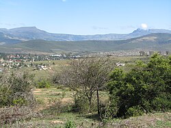
Keiskammahoek

Last updated
Keiskammahoek
View of KKH from hill.jpg
View of Keiskammahoek from the hill
South Africa Eastern Cape location map.svg
Red pog.svg
Keiskammahoek
South Africa adm location map.svg
Red pog.svg
Keiskammahoek
Africa location map.svg
Red pog.svg
Keiskammahoek
Coordinates: 32°41′S27°09′E / 32.683°S 27.150°E / -32.683; 27.150
Country Flag of South Africa.svg  South Africa
Province Flag of the Eastern Cape Province.png  Eastern Cape
District Amathole
Municipality Amahlathi
Area
[1]
  Total15.67 km2 (6.05 sq mi)
Elevation
670 m (2,200 ft)
Population
 (2011) [1]
  Total4,429
  Density280/km2 (730/sq mi)
Racial makeup (2011)
[1]
   Black African 97.1%
   Coloured 1.4%
   Indian/Asian 0.2%
   White 0.3%
  Other1.0%
First languages (2011)
[1]
   Xhosa 94.6%
   Afrikaans 1.8%
   English 1.1%
  Other2.6%
Time zone UTC+2 (SAST)
Postal code (street)
5670
PO box
5670
Area code 040
One of the buildings at the old St Matthews Mission School St Matthews Old building with treegrowing.jpg
One of the buildings at the old St Matthews Mission School

Keiskammahoek (also spelled Keiskamahoek) is a town in the Eastern Cape Province, South Africa. [2] From 1981 until the end of apartheid, the town was part of the Ciskei bantustan.

Contents

Geography

Keiskammahoek is a small rural town that is situated some forty kilometers to the West of King William's Town in the Amahlathi Local Municipality, which is one of seven local municipalities that constitute the Amathole District Municipality, Eastern Cape. Keiskammahoek is surrounded by a number of villages and peri-urban settlements that support the town.

Keiskammahoek is situated near the headlands of the Keiskamma River catchment area. It is located in the centre of four different biomes: Albany Thicket, Grasslands, Savannah and Afromontane forest.

History

The town was once an important commercial centre for the timber and agricultural industries. The settlement of the area since the 1800s also led to the large-scale exploitation and destruction of the natural environment. The timber industry has moved towards Stutterheim and the agricultural production has declined somewhat.

Just outside the town is St Matthew's High School, one of South Africa's historic schools. Founded as a mission school by Bishop of Grahamstown John Armstrong in 1854, the school was once a particularly thriving educational centre, and the large parish church is a local landmark. A hospital and training facility for nurses was opened at the site in 1923 and the secondary school began in 1926.

Like other church schools, the Anglican Church withdrew from direct involvement in the school as a result of the 1953 Bantu Education Act. The state bought much of St Matthews' land in 1970, and in 1976 the hospital was taken over by the Ciskei government. It closed ten years later, moving to Keiskammahoek, where it became known as the SS Gida Hospital. The high school continues as a state boarding school for girls (with male day students). A small clinic remains on the school site, and the ruins of many of the school's buildings are everywhere evident.

Currently the economy of Keiskammahoek relies mainly on grants from the State. The population has been steadily declining and many villages are still without basic services such as water and sanitation. However, the town still maintains some of the remnants of the historic past and there are a number of historic buildings to be found such as the Gilead Church.

Health facility

Keiskammahoek houses the medium-sized S.S. Gida Hospital, a Provincial government funded hospital for the Amahlathi area.

Other

Marguerite Poland's Shades is set in a fictionalised version of Keiskammahoek and based on life at the mission station. [3]

Notable residents

Related Research Articles

<span class="mw-page-title-main">Eastern Cape</span> Province in South Africa

The Eastern Cape is one of the nine provinces of South Africa. Its capital is Bhisho, but its two largest cities are East London and Gqeberha.

<span class="mw-page-title-main">Stellenbosch</span> Town in Western Cape, South Africa

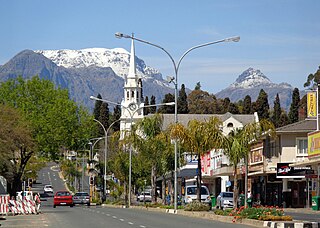
Stellenbosch is a town in the Western Cape province of South Africa, situated about 50 kilometres east of Cape Town, along the banks of the Eerste River at the foot of the Stellenbosch Mountain. The town became known as the City of Oaks or Eikestad in Afrikaans and Dutch due to the large number of oak trees that were planted by its founder, Simon van der Stel, to grace the streets and homesteads.

<span class="mw-page-title-main">Kokstad</span> A town in KwaZulu-Natal, South Africa

Kokstad is a town in the Harry Gwala District Municipality of KwaZulu-Natal Province, South Africa. Kokstad is named after the Griqua chief Adam Kok III who settled here in 1863. Kokstad is the capital town of the East Griqualand region, as it is also the biggest town in this region. It was built around Mount Currie, a local mountain range, by the city's founder Adam Kok III, for whom the town is named. Stad is the Dutch and Afrikaans word for "city".

<span class="mw-page-title-main">Klerksdorp</span> City in North West, South Africa

Klerksdorp is located in the North West Province, South Africa. Klerksdorp, the largest city in the North West Province, is located 165 km (103 mi) southeast of Mahikeng, the provincial capital. Klerksdorp was also the first capital of the then Transvaal Republic and used to be the home of the first Stock Exchange in the region. It became an important trading town linking Kimberley to Johannesburg. It became home to a mix of farmers, miners and immigrants servicing the two industries.

<span class="mw-page-title-main">Bethlehem, South Africa</span> Place in Free State, South Africa

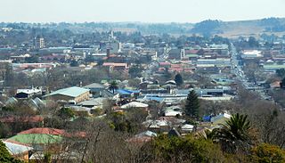
Bethlehem is a city in the eastern Free State province of South Africa that is situated on the Liebenbergs river along a fertile valley just north of the Rooiberg Mountains on the N5 road. It is the fastest growing city in the Free state province, with its target of being the third largest city after Bloemfontein and Welkom.

<span class="mw-page-title-main">Makhanda, South Africa</span> Town in Eastern Cape, South Africa

Makhanda, also known as Grahamstown, is a town of about 140,000 people in the Eastern Cape province of South Africa. It is situated about 110 kilometres (70 mi) northeast of Gqeberha and 130 kilometres (80 mi) southwest of East London. It is the largest town in the Makana Local Municipality, and the seat of the municipal council. It also hosts Rhodes University, the Eastern Cape Division of the High Court, the South African Library for the Blind (SALB), a diocese of the Anglican Church of Southern Africa, and 6 South African Infantry Battalion. Furthermore, located approximately 3 km south-east of the town lies the world renowned Waterloo Farm, the only estuarine fossil site in the world from 360 million years ago with exceptional soft-tissue preservation.

<span class="mw-page-title-main">Mdantsane</span> Township in the Eastern Cape, South Africa

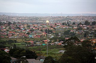
Mdantsane is a South African urban township situated 15 km away from East London and 37 km away from Qonce in the Eastern Cape. It is the second largest township in South Africa after Soweto in Gauteng.

<span class="mw-page-title-main">Wynberg, Cape Town</span> Place in Western Cape, South Africa

Wynberg is a southern suburb of the City of Cape Town in Western Cape, South Africa. It is situated between Plumstead and Kenilworth, and is a main transport hub for the Southern Suburbs of Cape Town.

<span class="mw-page-title-main">Brackenfell</span> Town in the Western Cape, South Africa

Brackenfell is a town in the Western Cape province of South Africa and a northern suburb of Cape Town, situated about 30 km north-east of the city. Regarded as the gateway to the Cape Winelands, Brackenfell is situated approximately 22 km north-west of Stellenbosch and 35 km south-west of Paarl and lies at the start of the Bottelary Hills Wine Route which follows the scenic and winding Bottelary Road towards Stellenbosch.

<span class="mw-page-title-main">Durbanville</span> Town in Western Cape, South Africa

Durbanville is a town in the Western Cape province of South Africa, part of the greater Cape Town metropolitan area. Durbanville is a semi-rural residential suburb on the north-eastern outskirts of the metropolis surrounded by farms producing wine and wheat.

<span class="mw-page-title-main">Beaufort West</span> Place in Western Cape, South Africa

Beaufort West is a town in the Western Cape province in South Africa. It is the largest town in the arid Great Karoo region, and is known as the "Capital of the Karoo". It forms part of the Beaufort West Local Municipality, with 34,085 inhabitants in 2011.

<span class="mw-page-title-main">Chris Hani District Municipality</span> District municipality in Eastern Cape, South Africa

The Chris Hani District Municipality is a landlocked district municipality situated in the centre of the Eastern Cape province of South Africa and is made up of eight local municipalities. Most of the communities are in rural areas. The landscape ranges from moist uplands and grassland hills to the arid Karoo scrubland.

<span class="mw-page-title-main">Alexandreia, Greece</span> Place in Macedonia, Greece

Alexandreia or Alexandria (Greek: Αλεξάνδρεια, Alexándreia [ale'ksaŋðria]; before 1953: Gidas is a city in the Imathia regional unit of Macedonia, Greece. Its population was 14,821 at the 2011 census. Alexandreia is a rapidly developing city focusing to boost its economy through agriculture, merchandising, alternative tourism and other alternative actions.

<span class="mw-page-title-main">Butterworth, South Africa</span> Place in Eastern Cape, South Africa

Butterworth, also known as Gcuwa, is a town in the Eastern Cape Province, South Africa. Butterworth has a population of 45,900 and is situated on the N2 national highway 111 km north of East London.

<span class="mw-page-title-main">Middelburg, Eastern Cape</span> Place in Eastern Cape, South Africa

Middelburg is a town in the Eastern Cape province of South Africa, in the Great Karoo. It lies in the Upper Karoo, 1,279 m above sea level, with a population of 19,000. It falls under the Inxuba Yethemba Local Municipality, in the Chris Hani District Municipality.

<span class="mw-page-title-main">Ciskei Defence Force</span> Defence force of the Republic of Ciskei

The Ciskei Defence Force (CDF) was established during March 1981 from the 141 Battalion of the South African Defence Force (SADF). It was the defence force of Ciskei, a bantustan that was controlled by the apartheid regime of South Africa. The CDF functioned as part of the 21 Battalion based near Lenasia, outside Johannesburg.

S.S. Gida Hospital is a Provincial government funded hospital for the Amahlathi Local Municipality area in Keiskammahoek, Eastern Cape in South Africa.

Emnyameni is a Xhosa community in Amahlathi Local Municipality within the Amathole District Municipality in the Eastern Cape province of South Africa, situated about 13 km north-west of Keiskammahoek. The community sits at the foot of the Mt Geju and Mt Belekumntana. It is made up of two villages, aptly named the Upper Emnyameni and the Lower Emnyameni.

Sada is a semi-rural settlement, situated 3 km away from Whittlesea, 30 km north of Seymour and 40 km south of Queenstown, Eastern Cape Province. The word Sada means "finally" or "at last" in isiXhosa because the first settlers struggled to find a place before they settled in the area in 1964.

St. Matthew's High School is a government high school in Keiskammahoek, Eastern Cape, South Africa. It has boarding facility for girls, day-boys do attend the school.

References

  1. 1 2 3 4 "Main Place Keiskammahoek". Census 2011.
  2. Keiskammahoek Home Page Archived 8 September 2009 at the Wayback Machine at Amahlathi.co.za
  3. Interview with Marguerite Poland, Sundayindybooks.blogspot.com. February 2013.