
Table Mountain is a flat-topped mountain forming a prominent landmark overlooking the city of Cape Town in South Africa. It is a significant tourist attraction, with many visitors using the cableway or hiking to the top. Table Mountain National Park is the most visited national park in South Africa, attracting 4.2 million people every year for various activities. The mountain has 8,200 plant species, of which around 80% are fynbos, meaning fine bush. It forms part of the Table Mountain National Park, and part of the lands formerly ranged by Khoe-speaking clans, such as the !Uriǁʼaes. It is home to a large array of mostly endemic fauna and flora.
The Northeast Kingdom is the northeast corner of the U.S. state of Vermont, approximately comprising Essex, Orleans and Caledonia counties and having a population at the 2010 census of 64,764. The term "Northeast Kingdom" is attributed to George D. Aiken, former Governor of Vermont and a U.S. senator, who first used the term in a 1949 speech.

Qacha's Nek is, since 1888, the camptown (capital) of Qacha's Nek District in Lesotho, only two kilometers from the South African border at 1,980 meters (6,500 ft) above sea level. It has a population of approximately 15,900 (2016). It is home to Machabeng Government Hospital, one of the two hospitals in the district.

The Two Oceans Marathon is a 56 kilometres (35 mi) ultramarathon and 21 kilometres (13 mi) half-marathon held annually in Cape Town, South Africa on the Saturday of the Easter weekend.
Volksrust is a town in the Mpumalanga province of South Africa near the KwaZulu-Natal provincial border, some 240 km southeast of Johannesburg, 53 km north of Newcastle and 80 km southeast of Standerton.
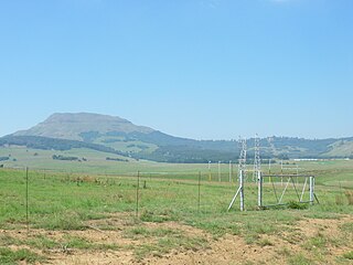
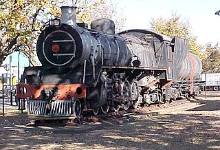
Laing's Nek, or Lang's Nek is a pass through the Drakensberg mountain range in South Africa, south of Charlestown, at 27°27′39″S29°52′10″E at an elevation of 5400 to 6,000 ft (1,800 m). It is the lowest part of a ridge that slopes from Majuba Hill east to the Buffalo River. Before the opening of the railway in 1891, the road over the nek was the main artery of communication between Durban and Pretoria. The railway crosses the pass via a 2,213 ft (675 m) tunnel.

The N2 is a national route in South Africa that runs from Cape Town through George, Gqeberha, East London, Mthatha, Port Shepstone and Durban to Ermelo. It is the main highway along the Indian Ocean coast of the country. Its current length of 2,255 kilometres (1,401 mi) makes it the longest numbered route in South Africa.

Constantiaberg is a large, whale-backed mountain that forms part of the mountainous spine of the Cape Peninsula in Table Mountain National Park, Cape Town, South Africa. It lies about 7 km south of Table Mountain, on the southern side of Constantia Nek. The mountain is 927 m high. It is not known who first ascended the peak.

The N4 is a national route in South Africa that runs from Skilpadshek on the Botswana border, past Rustenburg, Pretoria, eMalahleni and Mbombela, to Komatipoort on the Mozambique border. It forms the South African section of the Trans-Kalahari Corridor, which runs from Walvis Bay to Maputo, meaning that it links the east and west coasts of Southern Africa.

The N10 is a national route in South Africa connecting Gqeberha on the Eastern Cape coast with the Namibian border at Nakop, via Cradock, De Aar and Upington.

Cookhouse is a small village located in Eastern Cape province, South Africa, some 170 kilometres (110 mi) north of Port Elizabeth and 24 kilometres (15 mi) east of Somerset East, on the west bank of the Great Fish River.
The Slachter's Nek Rebellion was an uprising by Boers in 1815 on the eastern border of the Cape Colony.
Shanamkarak is a former Karok settlement in Humboldt County, California. It was located on the Klamath River, 1 mile (1.6 km) to 2 miles (3.2 km) below the confluence with the Salmon River; its precise location is unknown.
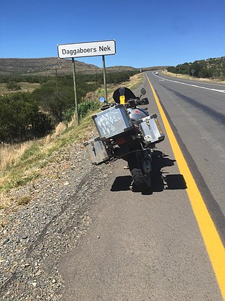
Daggaboers Nek Pass, also known simply as Daggaboers Nek, is situated in the Eastern Cape province of South Africa, on the N10 national route, between Cookhouse and Cradock. The tarred pass has a northern and southern approach, with double lanes on both ascents.
Dozens of fortifications were built in Cape Town and the Cape Peninsula between the 1650s and the 1940s. Most have gone, but a few still stand.

Cecilia is a section of the Table Mountain National Park on the lower eastern slopes of Table Mountain in Cape Town, located just to the south of Kirstenbosch National Botanical Garden. It was previously used for commercial logging and known as Cecilia Forest or Cecilia Plantation, but has now been given protected status and integrated into the National Park.

In the Colonies and former Boer Republics which became the Union of South Africa in 1910, several unofficial military decorations and medals were instituted and awarded during the nineteenth and early twentieth century. Sir Harry Smith's Medal for Gallantry is an unofficial military decoration for bravery, awarded for actions following the siege of Fort Cox in December 1850, at the beginning of the 8th Cape Frontier War. The medal was privately instituted in 1851 by Major General Sir Henry George Wakelyn Smith Bt GCB, at the time the Governor and Commander-in-Chief of the Cape of Good Hope.
Kloof Nek Road, one of South Africa's oldest roads, was built in 1848 as an access road for the suburban pass with the same name which was used primarily as a look-out post for soldiers and a supply route to Camps Bay. The route starts at Kloof Street on the edge of the city bowl and turns into Camps Bay Road at the end of a mountain pass running between Table Mountain and Lion's Head. Despite being only two kilometers long, it is very steep with an average gradient 1:11. The summit of Kloof Nek Road is a small but complicated intersection that's not clearly visible on approach and often catches motorists unaware. The road's steepness may be a contributor to the regular occurrence of often-fatal accidents on Kloof Nek Road.
Nontetha Nkwenkwe was a Xhosa prophetess who lived in colonial South Africa and began a religious movement that caused her to be committed to asylums by the South African government from 1923 until her death in 1935. She is regarded as one of the most remarkable female religious leaders associated with independent churches in the 1920s.

The Brandwater Basin is the drainage basin of the Brandwater River, a tributary of the Grootspruit River in the south-east of Orange Free State, South Africa, north of Lesotho. The basin is situated south of Bethlehem and south-east of Senekal, between the Witteberg to the west and north, the Rooiberge to the east, and the Drakensberg over the Caledon River to the south. It is also northwest of the Slaapkrans Basin and the Maloti Mountains on the northern border of Lesotho. Towns in the Brandwater Basin are Fouriesburg, founded in 1892, and Clarens, established in 1912.


