Burnshill

Last updated
Burnshill
South Africa Eastern Cape location map.svg
Red pog.svg
Burnshill
South Africa adm location map.svg
Red pog.svg
Burnshill
Coordinates: 32°46′05″S27°03′26″E / 32.768°S 27.0571°E / -32.768; 27.0571 Coordinates: 32°46′05″S27°03′26″E / 32.768°S 27.0571°E / -32.768; 27.0571
Country South Africa
Province Eastern Cape
District Amathole
Municipality Amahlathi
Area
[1]
  Total2.12 km2 (0.82 sq mi)
Population
(2011) [1]
  Total693
  Density330/km2 (850/sq mi)
Racial makeup (2011)
[1]
   Black African 99.7%
  Other0.3%
First languages (2011)
[1]
   Xhosa 98.8%
  Other1.2%
Time zone UTC+2 (SAST)
PO box
5688

Burnshill is a town in Amathole District Municipality in the Eastern Cape province of South Africa.

Amathole District Municipality District municipality in Eastern Cape, South Africa

Amathole is one of the 7 districts of Eastern Cape province of South Africa. The seat of Amathole is East London. Over 90% of its 892,637 people speak Xhosa. The district code is DC12. "Amathole" means calves, the name of the mountain range and forest which forms the northern boundary of the district.

Eastern Cape Province of South Africa

The Eastern Cape is a province of South Africa. Its capital is Bhisho, but its two largest cities are Port Elizabeth and East London. It was formed in 1994 out of the Xhosa homelands or bantustans of Transkei and Ciskei, together with the eastern portion of the Cape Province. It is the landing place and home of the 1820 Settlers. The central and eastern part of the province is the traditional home of the Xhosa people.

South Africa Republic in the southernmost part of Africa

South Africa, officially the Republic of South Africa (RSA), is the southernmost country in Africa. It is bounded to the south by 2,798 kilometres (1,739 mi) of coastline of Southern Africa stretching along the South Atlantic and Indian Oceans; to the north by the neighbouring countries of Namibia, Botswana, and Zimbabwe; and to the east and northeast by Mozambique and Eswatini (Swaziland); and it surrounds the enclaved country of Lesotho. South Africa is the largest country in Southern Africa and the 25th-largest country in the world by land area and, with over 57 million people, is the world's 24th-most populous nation. It is the southernmost country on the mainland of the Old World or the Eastern Hemisphere. About 80 percent of South Africans are of Sub-Saharan African ancestry, divided among a variety of ethnic groups speaking different African languages, nine of which have official status. The remaining population consists of Africa's largest communities of European (White), Asian (Indian), and multiracial (Coloured) ancestry.

Former mission station of the Glasgow Missionary Society, established at the foot of the Amathole Mountains in 1831. Named after John Burns, minister of the Barony Church, Glasgow, one of the founders of the society. It was destroyed in 1851. [2]
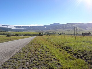
Amathole Mountains mountain range

Amatola, Amatole or Amathole are a range of densely forested mountains, situated in the Eastern Cape province of South Africa. The word Amatole means ‘calves’ in Xhosa, and Amathole District Municipality, which lies to the south, is named after these mountains.

Related Research Articles

Amathole Museum

The Amathole Museum, formerly the Kaffrarian Museum is a natural and cultural history museum located in King William's Town in the Eastern Cape province of South Africa. The museum houses the second largest collection of mammals in South Africa and includes the taxidermied body of Huberta, the hippopotamus.

Healdtown Place in Eastern Cape, South Africa

Healdtown is a small town located 10 km north-east of Fort Beaufort in the Eastern Cape province of South Africa. It is situated in Raymond Mhlaba Municipality in Amathole District in an area that was formerly part of the Ciskei. Nelson Mandela completed his schooling in Matric here.

Mbhashe Local Municipality Local municipality in Eastern Cape, South Africa

The Mbhashe Municipality is a remote outpost of the Eastern Cape of South Africa.

Great Kei Local Municipality Local municipality in Eastern Cape, South Africa

Great Kei Local Municipality is an administrative area in the Amathole District of the Eastern Cape in South Africa. The name "Kei" is of Khoi origin, meaning "sand". The municipality is named after the Great Kei River.

Willowvale, Eastern Cape Place in Eastern Cape, South Africa

Willowvale is a town in Amathole District Municipality in the Eastern Cape province of South Africa.

Peddie, Eastern Cape Place in Eastern Cape, South Africa

Peddie is a town in the Ngqushwa Local Municipality within the Amathole District Municipality in the Eastern Cape province of South Africa.

Middledrift, Eastern Cape Place in Eastern Cape, South Africa

Middledrift is a small town located 90 kilometres (60 mi) north-west of East London in the Eastern Cape province of South Africa. It is situated in Raymond Mhlaba Municipality in Amathole District in an area that was formerly part of the Ciskei.

Wesley, Eastern Cape Place in Eastern Cape, South Africa

Wesley is a town in Amathole District Municipality in the Eastern Cape province of South Africa.

Bodiam, Eastern Cape Place in Eastern Cape, South Africa

Bodiam is a town in Amathole District Municipality in the Eastern Cape province of South Africa.

Calderwood, Eastern Cape Place in Eastern Cape, South Africa

Calderwood is a village in Amathole District Municipality in the Eastern Cape province of South Africa.

Frankfort, Eastern Cape Place in Eastern Cape, South Africa

Frankfort is a town in Amathole District Municipality in the Eastern Cape province of South Africa.

Mhlangeni Place in Eastern Cape, South Africa

Mhlangeni is a settlement in Amathole District Municipality in the Eastern Cape province of South Africa.

Kei Road Place in Eastern Cape, South Africa

Kei Road is a town in Amathole District Municipality in the Eastern Cape province of South Africa.

Mazeppa Bay Place in Eastern Cape, South Africa

Mazeppa Bay is a town in Amathole District Municipality in the Eastern Cape province of South Africa.

Wooldridge, Eastern Cape Place in Eastern Cape, South Africa

Wooldridge is a town in Amathole District Municipality in the Eastern Cape province of South Africa.

Katberg Place in Eastern Cape, South Africa

Katberg is a hamlet high up in Raymond Mhlaba Municipality, Amathole District Municipality, in the Eastern Cape province of South Africa.

Qolora Mouth Place in Eastern Cape, South Africa

Qolora Mouth is a town in Amathole District Municipality in the Eastern Cape province of South Africa.

Border Post, Eastern Cape Place in Eastern Cape, South Africa

Border Post is a village in Amathole District Municipality in the Eastern Cape province of South Africa.

Mnyameni Place in Eastern Cape, South Africa

Emnyameni is a Xhosa community in Amahlathi Local Municipality within the Amathole District Municipality in the Eastern Cape province of South Africa, situated about 13 km north-west of Keiskammahoek. The community sits at the foot of the Mt Geju and Mt Belekumntana. It is made up of two villages, aptly named the Upper Emnyameni and the Lower Emnyameni.

References

  1. 1 2 3 4 "Main Place Burnshill". Census 2011.
  2. "Dictionary of Southern African Place Names (Public Domain)". Human Science Research Council. p. 101.