Dutywa

Last updated

Dutywa
Idutywa
N2 about to enter Idutywa (1568836305).jpg
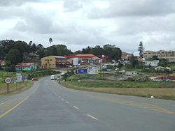
The N2 about to enter Idutywa
South Africa Eastern Cape location map.svg
Red pog.svg
Dutywa
South Africa adm location map.svg
Red pog.svg
Dutywa
Africa location map.svg
Red pog.svg
Dutywa
Coordinates: 32°06′S28°18′E / 32.100°S 28.300°E / -32.100; 28.300 Coordinates: 32°06′S28°18′E / 32.100°S 28.300°E / -32.100; 28.300
Country South Africa
Province Eastern Cape
District Amathole
Municipality Mbhashe
Established1858
Area
[1]
  Total20.83 km2 (8.04 sq mi)
Population
 (2011) [1]
  Total11,076
  Density530/km2 (1,400/sq mi)
Racial makeup (2011)
[1]
   Black African 96.6%
   Coloured 1.3%
   Indian/Asian 0.7%
   White 1.1%
  Other0.4%
First languages (2011)
[1]
   Xhosa 91.6%
   English 3.3%
  Other5.1%
Time zone UTC+2 (SAST)
Postal code (street)
5000
PO box
5000
Area code 047

Dutywa, also known as Idutywa, [2] is a town in Mbashe Local Municipality, Eastern Cape province, South Africa, that was founded in 1858 as a military fort after a dispute between a Natal Colony raiding party and its local people. [3] It is named after the Dutywa River, a tributary of the Mbhashe River. [4] The name means "place of disorder" in the Xhosa language; [5] its spelling was officially changed from "Idutywa" to "Dutywa" on 16 July 2004. [6] The settlement was laid out in 1884 and was made a municipality in 1913. [5] The town is the birthplace of former South African President, Thabo Mbeki. [7]

Dutywa is home to 11,076 people, 96.6% of who are Black African (Xhosa). [7]

Idutywa School of Excellence is a recognized school well known for producing excellent results for high pass rate in Matric.

The is Idutywa Mall was built so that the villagers would be able to do their shopping.

Bolotwa Location Botolwa Location by Cimiserco.jpg
Bolotwa Location
Farming by Anda Zaku Anda Zaku by Cimiserco .jpg
Farming by Anda Zaku
Employment by Industry [7]
SectorWorkers % of labour force [8]
Agriculture4020.3%
Mining / Quarrying1030.1%
Manufacturing5930.5%
Electricity / Gas / Water supply5930.5%
Construction4480.4%
Wholesale / Retail trade2,1461.7%
Transport / Storage / Communication2060.2%
Financial / Insurance / Real estate1,1740.5%
Community / Social / Personal services2,8432.3%
Private households / Other11,8744.6%
Population by Monthly Income (incl Social Grants) [7]
Income (R)People % of population
R 204,80100.0%
R 102,401204,8001240.0%
R 51,201102,40000.0%
R 25,60151,2001700.1%
R 12,80125,6004080.2%
R 6,40112,8002,7681.1%
R 3,2016,4003,4781.4%
R 1,6013,2003,8671.5%
R 8011,60032,60612.7%
R 40180015,2226.0%
R 140027,08410.6%
No income166,16564.9%

Related Research Articles

<span class="mw-page-title-main">Eastern Cape</span> Province in South Africa

The Eastern Cape is one of the provinces of South Africa. Its capital is Bhisho, but its two largest cities are East London and Port Elizabeth.

<span class="mw-page-title-main">Ciskei</span> Former bantustan in South Africa (1981-94)

Ciskei was a Bantustan for the Xhosa people-located in the southeast of South Africa. It covered an area of 7,700 square kilometres (3,000 sq mi), almost entirely surrounded by what was then the Cape Province, and possessed a small coastline along the shore of the Indian Ocean.

<span class="mw-page-title-main">Paarl</span> Town in Western Cape, South Africa

Paarl is a town with 112,045 inhabitants in the Western Cape province of South Africa. It is the third-oldest city and European settlement in the Republic of South Africa and the largest town in the Cape Winelands. Due to the growth of the Mbekweni township, it is now a de facto urban unit with Wellington. It is situated about 60 kilometres (37 mi) northeast of Cape Town in the Western Cape Province and is known for its scenic environment and viticulture and fruit-growing heritage.

<span class="mw-page-title-main">Matatiele</span> Place in Eastern Cape, South Africa

Matatiele is a town located in the northern part of the Eastern Cape Province of South Africa. According to the South African National Census of 2011, its 12,466 residents and 4,107 households make Matatiele the largest populated town in the Matatiele Local Municipality.

<span class="mw-page-title-main">Drakenstein Local Municipality</span> Local municipality in Western Cape, South Africa

Drakenstein Municipality is a local municipality located within the Cape Winelands District Municipality, in the Western Cape province of South Africa. As of 2011 it had a population of 251,262. Its municipality code is WC023.

<span class="mw-page-title-main">Bergrivier Local Municipality</span> Local municipality in Western Cape, South Africa

Bergrivier Local Municipality is a local municipality in the Western Cape province of South Africa. It governs the towns of Piketberg, Velddrif and Porterville, as well as the surrounding villages and rural areas. As of 2011 it had a population of 61,897. It is located within the West Coast District Municipality and has municipality code WC013.

<span class="mw-page-title-main">Hessequa Local Municipality</span> Local municipality in Western Cape, South Africa

Hessequa Local Municipality is a municipality located in the Western Cape Province of South Africa. It is flanked by the lower Breede River to the west and the Gourits River to the east. As of 2011 the population was 52,642. Its municipality code is WC042. The name Hessequa, meaning "people of the trees", refers to the tribe of indigenous Khoikhoi people.

<span class="mw-page-title-main">Makhanda, South Africa</span> Town in Eastern Cape, South Africa

Grahamstown is a town of about 140,000 people in the Eastern Cape province of South Africa. It is situated about 110 kilometres (70 mi) northeast of Port Elizabeth and 130 kilometres (80 mi) southwest of East London. It is the largest town in the Makana Local Municipality, and the seat of the municipal council. It also hosts Rhodes University, the Eastern Cape Division of the High Court, the South African Library for the Blind (SALB), a diocese of the Anglican Church of Southern Africa, and 6 South African Infantry Battalion. Furthermore, located approximately 3 km south-east of the town lies the world renowned Waterloo Farm, the only estuarine fossil site in the world from 360 million years ago with exceptional soft-tissue preservation.

<span class="mw-page-title-main">Gqeberha</span> City in Eastern Cape, South Africa

Gqeberha or Port Elizabeth is a major seaport and the most populous city in the Eastern Cape province of South Africa. It is the seat of the Nelson Mandela Bay Metropolitan Municipality, South Africa's second-smallest metropolitan district by area size. It is the sixth-most populous city in South Africa and is the cultural, economic and financial centre of the Eastern Cape.

<span class="mw-page-title-main">Fengu tribe</span> Xhosa Tribe

The amaMfengu was a reference of Xhosa clans whose ancestors were refugees that fled from the Mfecane in the early-mid 19th century to seek land and protection from the Xhosa. These refugees were assimilated into the Xhosa nation and were officially recognized by the then king, Hintsa. The term derives from the Xhosa verb "ukumfenguza" which means to wander about seeking service.

<span class="mw-page-title-main">Qonce</span> Place in Eastern Cape, South Africa

King William's Town, officially known as Qonce, is a city in the Eastern Cape province of South Africa along the banks of the Buffalo River. The city is about 60 kilometres (37 mi) northwest of the Indian Ocean port of East London. It has a population of around 35,000 inhabitants and forms part of the Buffalo City Metropolitan Municipality.

<span class="mw-page-title-main">Sarah Baartman District Municipality</span> District municipality in Eastern Cape, South Africa

Sarah Baartman District Municipality is situated in the western part of the Eastern Cape province, covering an area of 58 242 square kilometres. The area of the district municipality includes seven local municipalities. The seat of Sarah Baartman is the city of Gqeberha, although Gqeberha is not itself in the district. The languages most spoken among the 388,201 people are Xhosa and Afrikaans. The district code is DC10.

Ngcobo is a town in the Eastern Cape province of South Africa.

<span class="mw-page-title-main">Xhosa Wars</span> (1779-1879) Wars between the Xhosa Kingdom and the British Empire as well as Dutch settlers

The Xhosa Wars were a series of nine wars between the Xhosa Kingdom and the British Empire as well as Trekboers in what is now the Eastern Cape in South Africa. These events were the longest-running military action in the history of European colonialism in Africa.

<span class="mw-page-title-main">Butterworth, South Africa</span> Place in Eastern Cape, South Africa

Butterworth, also known as Gcuwa, is a town in the Eastern Cape Province, South Africa. Butterworth has a population of 45,900 and is situated on the N2 national highway 111 km north of East London.

Qubudile Richard Dyantyi has represented the African National Congress (ANC) in the National Assembly since 2019. Before that, he was a Member of the Western Cape Provincial Parliament and served as the Western Cape's Member of the Executive Council (MEC) for Local Government and Housing from 2005 to 2008. In 2021, he was elected chairperson of the national parliament's Committee for the Section 194 Enquiry into Busisiwe Mkhwebane's fitness to hold office.

<span class="mw-page-title-main">Mbhashe Local Municipality</span> Local municipality in Eastern Cape, South Africa

The Mbhashe Municipality is a rural outpost of the Eastern Cape of South Africa.

<span class="mw-page-title-main">Port St. Johns Local Municipality</span> Local municipality in Eastern Cape, South Africa

Port St. Johns Local Municipality is an administrative area in the OR Tambo District of Eastern Cape in South Africa.

<span class="mw-page-title-main">Fingoland</span>

Fingoland was a historical territory situated in what is now the Eastern Cape, South Africa. It was inhabited primarily by the Xhosa people of the Mfengu clans, and was located in the south-west portion of the "Transkei" region.

<span class="mw-page-title-main">Thembuland</span> Natural region in South Africa

Thembuland, Afrikaans: Temboeland, is a natural region in the Eastern Cape province of South Africa. Its territory is the traditional region of the abaThembu, one of the states of the Xhosa nation.

References

  1. 1 2 3 4 "Main Place Dutywa". Census 2011.
  2. Jenkins, Elwyn (2007), Falling into place: the story of modern South African place names, David Philip Publishers, p. 75
  3. Wild Coast Towns: Idutywa Archived 19 August 2008 at the Wayback Machine
  4. Dictionary of Southern African Place Names
  5. 1 2 "Idutywa". Routes Travel Info Portal. Archived from the original on 25 January 2008. Retrieved 17 January 2008.
  6. Mlambo-Ngcuka, Phumzile (as Minister of Arts and Culture) (16 July 2004). "Approval of official place names". Government Gazette. Pretoria: Government Printer. 26552: 9–11. Archived from the original on 13 March 2012.
  7. 1 2 3 4 "Dutywa the Place of Disorder". SABS NEWS. Archived from the original on 3 February 2021.
  8. says, PATEKA POTSO (2 October 2019). "Idutywa School Of Excellence | Registration | Fees | Contacts" . Retrieved 27 July 2022.