Chaleur Bay, also Chaleurs bay, baie of Chaleur is an arm of the Gulf of Saint Lawrence located between Quebec and New Brunswick, Canada.

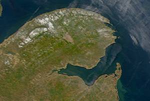
Salcombe is a popular resort town in the South Hams district of Devon, south west England. The town is close to the mouth of the Kingsbridge Estuary, mostly built on the steep west side of the estuary. It lies within the South Devon Area of Outstanding Natural Beauty (AONB). The town's extensive waterfront and the naturally sheltered harbour formed by the estuary gave rise to its success as a boat and shipbuilding and sailing port and, in modern times, tourism especially in the form of pleasure boats and yachting. The town is also home to a traditional shellfish fishing industry. The town is part of the electoral ward of Salcombe and Malborough, for which the 2011 census recorded a total population of 3,353.

The Oregon Coast is a coastal region of the U.S. state of Oregon. It is bordered by the Pacific Ocean to its west and the Oregon Coast Range to the east, and stretches approximately 362 miles (583 km) from the California state border in the south to the Columbia River in the north. The region is not a specific geological, environmental, or political entity, and includes the Columbia River Estuary.

Bruny Island is a 362-square-kilometre (140 sq mi) island located off the south-eastern coast of Tasmania, Australia. The island is separated from the Tasmanian mainland by the D'Entrecasteaux Channel, and its east coast lies within the Tasman Sea. Storm Bay is located to the island's northeast. Both the island and the channel are named after French explorer, Antoine Bruni d'Entrecasteaux. Its traditional Aboriginal name is lunawanna-allonah, which survives as the name of two island settlements, Alonnah and Lunawanna.

Plettenberg Bay, nicknamed Plet or Plett, is the primary town of the Bitou Local Municipality in the Western Cape Province of South Africa. As of the census of 2001, there were 29,149 population. It was originally named Bahia Formosa by early Portuguese explorers and lies on South Africa's Garden Route 210 km from Port Elizabeth and about 600 km from Cape Town.
The Garden Route is a 300-kilometre (190 mi) stretch of the south-eastern coast of South Africa which extends from Witsand in the Western Cape to the border of Tsitsikamma Storms River in the Eastern Cape. The name comes from the verdant and ecologically diverse vegetation encountered here and the numerous estuaries and lakes dotted along the coast. It includes towns such as Knysna, Plettenberg Bay, Mossel Bay, Great Brak River, Little Brak River, Wilderness, Sedgefield and Nature's Valley; with George, the Garden Route's largest city and main administrative centre.

Port Elizabeth, officially renamed Gqeberha and colloquially often referred to as P.E., is a major seaport and the most populous city in the Eastern Cape province of South Africa. It is the seat of the Nelson Mandela Bay Metropolitan Municipality, South Africa's second-largest metropolitan district by area size. It is the sixth-most-populous city in South Africa and is the cultural, economic and financial centre of the Eastern Cape.

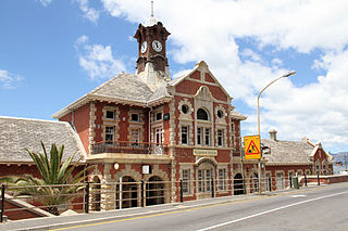
Jeffreys Bay is a town of 27,107 inhabitants as of the 2011 census in the Eastern Cape province of South Africa. It Is the seat of the Kouga municipality and is famous amongst surfers as a surf capital due to the right-hand point break at Supertubes Beach. The town is situated just off the N2 Highway, about 75 kilometres southwest of Port Elizabeth.
Muizenberg is a beach-side town in the Western Cape, South Africa. It is situated where the shore of the Cape Peninsula curves round to the east on the False Bay coast. It is considered to be the main surfing spot in Cape Town and is currently home to a surfing community, centered on the popular 'Surfer's Corner'.
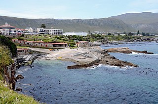
Hermanus, is a town on the southern coast of the Western Cape province of South Africa. It is known for Southern Right whale watching during the southern winter to spring seasons, and is a popular retirement location.

The Tsitsikamma National Park is a protected area on the Garden Route, Western Cape and Eastern Cape, South Africa. It is a coastal reserve well known for its indigenous forests, dramatic coastline, and the Otter Trail. On 6 March 2009 it was amalgamated with the Wilderness National Park and various other areas of land to form the Garden Route National Park.

Tourism in Sydney, Australia forms an important part of the city's economy. The city received 12 million domestic visitors and 4.1 million international visitors in year ending June 2019, however the number of visitors is expected to decrease in 2020. The most famous attractions include the Sydney Opera House, and the Sydney Harbour Bridge. Other attractions include the Sydney Mardi Gras, Royal Botanical Gardens, Luna Park, the beaches and Sydney Tower.

Wales is an emerging tourist destination, with 9.39m visitors to Conwy alone in 2018 and 8,078,900 visitors to National Trust and Wales Tourist Board destinations in 2002. As of 2017 the tourism industry in Wales has been estimated to have an annual turnover of £4.8 billion.

The East Coast Trail (ECT) is a long-distance coastal footpath located in the Canadian province of Newfoundland and Labrador. It is a developed trail over 336 kilometres (209 mi) long, creation of which began in 1994. It is made up of 25 linked wilderness paths and passes through more than 30 communities. It was named one of the best adventure destinations by National Geographic in 2012 and is extended and improved yearly.
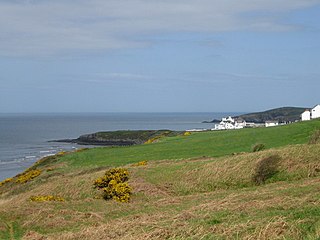
Gwbert, also known as Gwbert-on-Sea, is a cliff-top coastal village in Y Ferwig community, Ceredigion, Wales. It lies at the most southerly coastal point of Ceredigion, on the eastern shore of the Teifi estuary, from where there are views westwards over Cardigan Bay, and south-westwards to Poppit Sands and the headland of Cemaes Head, in neighbouring Pembrokeshire. It is reached by the B4548 road from the town of Cardigan, 2.8 miles (4.5 km) away.

Tourism in Brisbane is an important industry for the Queensland economy, being the third-most popular destination for international tourists after Sydney and Melbourne.

The Wild Coast is a section of the coast of the Eastern Cape, a province of South Africa. The region stretches from East London in the south to the border of KwaZulu-Natal in the north. It is the traditional home of the Mpondo people, and the birthplace of many prominent South Africans, including Nelson Mandela and Thabo Mbeki.
Kei Mouth is a resort town on the southeast coast of South Africa, situated in the Wild Coast region of the Eastern Cape Province, situated 94 kilometres from the city of East London. The town is situated on the Indian Ocean coast, on the western bank of the Great Kei River, and has one of the country's three remaining car transporting pontoon river ferries.

Cape Fatucama is a cape or large headland a short distance north east of Dili, on the north coast of East Timor. It is best known as the site of the Cristo Rei of Dili, a colossal statue of Jesus Christ.
The Double Mouth Nature Reserve, part of the greater East London Coast Nature Reserve, is a coastal reserve in the Wild Coast region of the Eastern Cape. Alongside it are the Quko River mouth and the 50-metre high Morgan Bay Cliffs.


