UMaine Deepwater Offshore Wind Test Site

Last updated

USA Maine location map.svg
Purple pog.svg
UMaine Deepwater Offshore Wind Test Site
UMaine Deepwater Offshore Wind Test Site (Maine)

The University of Maine (UMaine) Deepwater Offshore Wind Test Site, located nearly 3 miles south west of Monhegan Island, Maine is available for use by commercial and non-commercial entities in partnership with the University of Maine, or the University of Maine itself, to research and develop ocean energy devices, such as floating wind turbines or wave energy converters.

Contents

The University of Maine asserts that the test site is among the most extensively studied in the Gulf of Maine. [1]

The site was established under Maine law in 2009. The legislation formally designates the test site as the "Maine Offshore Wind Energy Research Center." [2]

Maine Aqua Ventus I, GP, LLC, is pursuing a 12 MW demonstration offshore wind pilot project in the test site, with deployment and commercial operations planned for 2020. [3]

Allowable uses

The following research and development efforts are allowable in the UMaine Deepwater Offshore Wind Test Site, per LD 1465: [2]

  1. A wind energy development project that uses a wind turbine to convert wind energy into electrical energy with no more than 2 wind energy turbines.
  2. Up to 3 meteorological towers per wind turbine.
  3. One submerged utility line with maximum capacity of 25 megawatts.
  4. Up to 2 wave energy converters, which use the motion of the ocean surface waves to generate electricity.
  5. An ocean sensor package, which refers to an instrument that would measure metocean data at the site.

There are no enhanced limitations placed on traditional commercial or recreational uses within the test site. [1]

Environmental and ecological surveys completed at the site

The University of Maine and its partners conducted a variety of ecological and environmental studies to characterize the UMaine Deepwater Offshore Wind Test Site, primarily between 2010 and 2013. Studies include baseline data on benthic invertebrates, marine mammals, birds, fish, and others. [4]

Survey results were published in 2011 in a University of Maine-published report, entitled: "Maine Offshore Wind Report." The report was funded by the U.S. Department of Energy, National Science Foundation, Rockefeller Brothers Fund, and others. [5]

NERACOOS buoy data

Hourly buoy data near the UMaine Deepwater Offshore Wind Test Site is available viewing and download from the Northeastern Regional Association of Coastal Ocean Observing Systems (NERACOOS) buoy E01. Available real-time weather and ocean data includes winds, waves, visibility, air temperature, and water temperature at the UMaine Deepwater Offshore Wind Test Site. [6]

This University of Maine graphic shows the location and proximity of the UMaine Deepwater Offshore Wind Test Site with respect to Monhegan Island. UMaine Deepwater Offshore Wind Test Site map.png
This University of Maine graphic shows the location and proximity of the UMaine Deepwater Offshore Wind Test Site with respect to Monhegan Island.

Site selection

The UMaine Deepwater Offshore Wind Test Site was designated to the University of Maine by the 124th Legislature of the State of Maine in 2009. As a result of recommendations from Governor John E. Baldacci's Ocean Energy Task Force, the Maine Department of Conservation identified three locations off the coast of Maine as Wind Energy Test Areas. [7] The sites were chosen following a public outreach process led by the Maine State Planning Office in cooperation with the Maine State Planning Office, Department of Environmental Protection, Department of Marine Resources, and the University of Maine. [8] In December 2009, the Maine Department of Conservation designated the location off of Monhegan Island based on its distance from the mainland shore and greater water depths. [9]

Site Selection Methodology

In September 2009, the Maine Department of Conservation released a document regarding the Maine Offshore Energy Demonstration Area Siting Initiative, which worked to establish several areas within Maine state waters that would be technically appropriate for an offshore wind demonstration area. The document stated that demonstration areas would be identified as a "three pronged approach," that would consider: geographical information system "showstoppers," human use and activities, and environmental considerations. [10]

Further, the document states: "Through a combination of anthropogenic, environmental, and geophysical analyses, the State of Maine hopes to site these ocean energy testing and demonstration projects in areas with the fewest conflicts, or at the very least, minimize what conflicts there will be. Adaptive Management will play a critical role in the duration of a project, or may affect how the project operates, once it is built." [11]

In October 2009, the Maine Department of Conservation and Maine State Planning Office released a document that detailed site selection methodology for the Maine Offshore Energy Demonstration Area Siting Initiative.

The document outlines two phases. The first phrase focused on technical identification, public scoping sessions, and state consultation with state agencies. The second phase focused on map analysis (of ecological concerns, geology, obstructions, infrastructure, human uses of the marine environment, and viewshed) followed by a ranking process that gathered written and oral comments from a variety of sources, including fishermen, state agencies, and other interested parties. [12]

Matthew Nixon of the Maine State Planning Office provided a culminating presentation at a "Developer's Summit," sponsored by the University of Maine in February 2011, describing the technical identification process and more than 40 public scoping sessions held in 2009. [13]

Proposed projects

Maine Aqua Ventus I, GP, LLC, is pursuing a 12 MW demonstration project in the test site. The project would feature two 6 MW wind turbines mounted on a University of Maine-developed VolturnUS floating concrete hull.

Sections of the VolturnUS will be fabricated in Hampden, Maine, and Searsport, Maine, and towed to the test site. [3] An AC cable will join the turbines, and a subsea power cable will connect the test site to a point onshore. The project has a planned 20-year duration, as indicated in the project's Power Purchase Agreement draft term sheet with the Maine Public Utilities Commission. [14]

Project participants include Emera, Inc., Cianbro Corporation, DCNS, and the University of Maine. Deployment and commercial operation of the two units is currently planned for 2019. [3]

Reception by Monhegan Island

Monhegan Island is located 12 nautical miles off the mainland. The population was 75 at the 2000 census. Monhegan Plantation created and authorized the Monhegan Energy Task Force to, "represent Monhegan in communications and negotiations with Maine Aqua Ventus regarding all aspects of the proposed offshore wind project, including the planning construction, operation, and decommissioning phases." [15]

As part of their proposed contract with the Maine Public Utilities Commission through a Power Purchase Agreement, Maine Aqua Ventus has an obligation [16] to provide local benefit to Monhegan through a subsea cable interconnection with Central Maine Power or an alternative negotiated benefit. As of November 1, 2016, the Monhegan Energy Task Force contracted with law firm Eaton Peabody to negotiate the community benefits agreement with Maine Aqua Ventus. [17]

The test site and proposed project has created ongoing discussion on the Island, with residents considering potential impacts to their community. [18]

Community response

In early July 2016, the Monhegan Energy Task Force conducted a survey to gauge community interest and sentiment towards Maine Aqua Ventus and the proposed offshore wind demonstration project. The survey broke results down between all respondents (registered voter, property owner, year-round resident, or seasonal worker) and exclusively Monhegan registered voters. The survey found that respondents were more supportive of the project (43.7%) versus opposed (40.2%) with a small percentage of undecided (16%). This support was found to be stronger among Monhegan Registered Voters. [19]

The same survey asked if Monhegan Plantation should cease to engage with Maine Aqua Ventus overall. The Monhegan Energy Task Force reported that nearly 80% of Registered Voters should engage with Maine Aqua Ventus and pursue a community benefit agreement. [20]

In late July 2016, Monhegan Plantation held a special town meeting to see if the plantation to pursue development of a community benefits agreement with Maine Aqua Ventus. This vote passed with 31 to 1 registered voters in favor. [17] [21] [22]

A group called "Protect Monhegan," formed in November 2016, led by Monhegan resident Travis Dow, to express opposition to the Maine Aqua Ventus project. [23]

On February 8, 2017, Maine State Senator Dana Dow (R-Damariscotta) issued a statement suggesting he would introduce a bill on behalf of "Protect Monhegan," to prohibit a wind energy test area within 10 miles of Monhegan Island's lobster conservation area. [24] [25] Formal bill language was not issued with the Senator's statement, made through the State's Republican party website.

On February 7, 2017, during a briefing of the State's joint legislative committee on Energy, Utilities, and Technology (EUT Committee), Dr. Habib Dagher of the University of Maine asserted that moving the test site would "kill the project." [26]

The EUT committee voted Ought Not to Pass Pursuant To Joint Rule 310, May 23, 2017. [27]

See also

Related Research Articles

<span class="mw-page-title-main">Wind power in the United States</span>

Wind power is a branch of the energy industry that has expanded quickly in the United States over the last several years. From January through December 2021, 379.8 terawatt-hours were generated by wind power, or 9.23% of all generated electrical energy in the United States. The average wind turbine generates enough electricity in 46 minutes to power the average American home for one month. In 2019, wind power surpassed hydroelectric power as the largest renewable energy source generated in the U.S.

<span class="mw-page-title-main">Wind power in California</span> Electricity from large wind farms

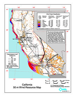
Wind power in California had initiative and early development during Governor Jerry Brown's first two terms in the late 1970s and early 1980s. The state's wind power capacity has grown by nearly 350% since 2001, when it was less than 1,700 MW. In 2016, wind energy supplied about 6.9% of California's total electricity needs, or enough to power more than 1.3 million households. Most of California's wind generation is found in the Tehachapi area of Kern County, California, with some large projects in Solano, Contra Costa and Riverside counties as well. California is among the states with the largest amount of installed wind power capacity. In recent years, California has lagged behind other states when it comes to the installation of wind power. It was ranked 4th overall for wind power electrical generation at the end of 2016 behind Texas, Iowa, and Oklahoma. As of 2019, California had 5,973 megawatts (MW) of wind power generating capacity installed.

Floating wind turbine Type of wind turbine

A floating wind turbine is an offshore wind turbine mounted on a floating structure that allows the turbine to generate electricity in water depths where fixed-foundation turbines are not feasible. Floating wind farms have the potential to significantly increase the sea area available for offshore wind farms, especially in countries with limited shallow waters, such as Japan, France and US West coast. Locating wind farms further offshore can also reduce visual pollution, provide better accommodation for fishing and shipping lanes, and reach stronger and more consistent winds.

There are a number of wind power projects in the state of Maine, totaling more than 900 megawatts (MW) in capacity. In 2020 they were responsible for 24% of in-state electricity production. In 2019, Maine had more wind capacity than the other five New England states combined, at 923 MW.

New York ranked 11th in the United States at the end of 2013 for installed wind power capacity, with 1,722 MW installed. In 2016, wind power provided 2.94% of in state energy production. This increased to 3.66% in 2019.

Ørsted U.S. Offshore Wind is an offshore wind energy development group that is affiliated with Ørsted, a Danish firm. It is joint headquartered in Boston, Massachusetts and Providence, Rhode Island. As of 2019, it was involved in some of the largest offshore wind farm projects in the United States.

Alpha Ventus Offshore Wind Farm

Alpha Ventus Offshore Wind Park is Germany's first offshore wind farm. It is situated in the North Sea 45 kilometres (28 mi) north of the island of Borkum.

Wind power in Massachusetts Electricity from wind in one U.S. state

The U.S. state of Massachusetts has vast wind energy resources offshore, as well as significant resources onshore. The 2016 update to the states's Clean Energy and Climate Plan had a goal of reducing 1990 baseline greenhouse gas emissions levels by 25% by 2020. Current goals include installing 3,500 megawatts (MW) of offshore wind power in the state by 2035. However, as of Q4 2021 the state had only 120 MW of wind powered electricity generating capacity, responsible for generating 0.9% of in-state electricity production. The state has awarded contracts to two offshore projects, the 800 MW Vineyard Wind project and 804 MW Mayflower Wind project. Construction began on the Vineyard Wind 1 project on November 18, 2021, after a long fight for approval.

Wind power in New Jersey is in the early stages of development. As of 2022, New Jersey has just six wind turbines, but the state has plans to develop several major offshore wind projects on the continental shelf of the Atlantic Ocean off the southern Jersey Shore. Legislation has been enacted to support the industry through economic incentives and to permit wind turbines on existing piers.

Wind power in Delaware Electricity from wind in one U.S. state

The potential of on-shore wind power in Delaware is minimal, having a potential of generating at most 22 GWh/year. Delaware's principal wind potential is from offshore wind. A 2012 assessment estimates that 15,038 MW of offshore wind turbines could generate 60,654 GWh/year. Delaware generated 11,522 GWh from all generating sources in 2011.

Block Island Wind Farm

Block Island Wind Farm is the first commercial offshore wind farm in the United States, located 3.8 miles (6.1 km) from Block Island, Rhode Island in the Atlantic Ocean. The five-turbine, 30 MW project was developed by Deepwater Wind. Construction began in 2015 and in late summer 2016 five Alstom Haliade 150-6-MW turbines were erected. Operations were launched in December 2016. It is the largest project using wind power in Rhode Island.

Wind power in Virginia Electricity from wind in one U.S. state

Wind power in Virginia is in the early stages of development. In March 2015, Virginia became the first state in the United States to receive a wind energy research lease to build and operate offshore wind turbines in federal waters. As of 2019, Virginia had no utility scale wind farms.

Wind power in Maryland Electricity from wind in one U.S. state

Wind power in Maryland, which has land-based and offshore resources, is in the early stages of development. As of 2016, Maryland has 191 megawatts (MW) of wind powered electricity generating capacity, responsible for 1.4% of in-state generated electricity. Two offshore wind farm projects that will supply wind-generated power to the state are underway.

The DeepCwind Consortium is a national consortium of universities, nonprofits, utilities, and industry leaders. The mission of the consortium is to establish the State of Maine as a national leader in floating offshore wind technology. Much of the consortium's work and resulting research has been funded by the U.S. Department of Energy, the National Science Foundations, and others.

UMaine Advanced Structures and Composites Center

The Advanced Structures and Composites Center is an independent research unit at the University of Maine that provides research, education, and economic development encompassing material sciences, manufacturing and engineering of composites and structures.

VolturnUS

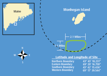
The VolturnUS is a floating concrete structure that supports a wind turbine, designed by University of Maine Advanced Structures and Composites Center and deployed by DeepCwind Consortium in 2013. The VolturnUS can support wind turbines in water depths of 150 ft (46 m) or more. The DeepCwind Consortium and its partners deployed a 1:8 scale VolturnUS in 2013. Efforts are now underway by Maine Aqua Ventus 1, GP, LLC, to deploy to full-scale VolturnUS structures off the coast of Monhegan Island, Maine, in the UMaine Deepwater Offshore Wind Test Site. This demonstration project, known as New England Aqua Ventus I, is planned to deploy two 6 MW wind turbines by 2020.

Skipjack is a 120 MW capacity off shore wind farm, proposed by Ørsted US Offshore Wind to be built on the Outer Continental Shelf Offshore Delaware, approximately 16.9 nautical miles-19.5 miles (31.4 km) from the coast opposite Fenwick Island. It is projected that the project, which will provide power to Maryland, will be commissioned in 2022. It is one of two offshore wind farm projects providing wind power to Maryland, the other being Marwind.

South Fork Wind Farm is a utility-scale offshore wind farm currently being constructed on the Outer Continental Shelf Offshore Rhode Island (RI) which will provide energy to New York state.

The Coastal Virginia Offshore Wind (CVOW) is an offshore wind energy project located about 43 km off the coast of Virginia Beach, Virginia, U.S. The initial phase, a two-turbine, 12-MW pilot project constructed in 2020, is the second utility scale offshore wind farm operating in the United States. Dominion Energy and Ørsted US Offshore Wind collaborated on the project, which is estimated to have cost $300 million and is expected to generate enough electricity to power up to 3,000 homes. It is the first utility scale wind farm serving Virginia and the first built in U.S. federal waters, in a wind lease area that covers about 2,135 acres.

References

  1. 1 2 "UMaine Deepwater Offshore Wind Test Site". University of Maine. University of Maine. Retrieved February 21, 2017.
  2. 1 2 SP0545 LD 1465. "An Act To Facilitate Testing and Demonstration of Renewable Ocean Energy Technology" (PDF). 124th Maine State Legislature. Retrieved February 21, 2017.
  3. 1 2 3 "Offshore Wind". Advanced Structures and Composites Center. University of Maine. Retrieved February 21, 2017.
  4. "Baseline Physical and Ecological Studies Completed to Date". UMaine Deepwater Offshore Wind Test Site at Monhegan Island. University of Maine.
  5. "Maine Offshore Wind Report". Advanced Structures and Composites Center. University of Maine. Retrieved February 21, 2017.
  6. "NERACOOS | weather | ocean | marine forecast | waves | buoy | marine weather | water temperature | wind". www.neracoos.org. Retrieved February 22, 2017.
  7. Final Report of the Ocean Energy Task Force to Governor John E. Baldacci (PDF). State of Maine. 2009.
  8. "Designation of Offshore Wind Energy Test Areas" (PDF). University of Maine. State of Maine Department of Conservation. Retrieved February 21, 2017.
  9. "Designation of Offshore Wind Energy Test Areas" (PDF). University of Maine. State of Maine Department of Conservation. Retrieved February 21, 2017.
  10. Siting Offshore Energy in Maine (PDF). Maine Department of Conservation. 2009.
  11. Siting Offshore Energy in Maine (PDF). Maine Department of Conservation. 2009.
  12. Maine Offshore Energy Demonstration Area Siting Initiative - Site Selection Methodology (PDF). Maine Department of Conservation. 2009.
  13. Nixon, Matthew. "The Ocean Energy Demonstration Siting Initiative" (PDF). University of Maine. Maine State Planning Office. Retrieved February 21, 2017.
  14. "Maine Aqua Ventus I Proposed Term Sheet" (PDF). Maine Aqua Ventus. Retrieved February 21, 2017.
  15. "About Monhegan Energy Task Force". Monhegan Energy Info. Retrieved February 21, 2017.
  16. "Maine Aqua Ventus I Proposed Term Sheet" (PDF). Maine Aqua Ventus. Retrieved February 21, 2017.
  17. 1 2 "Community Benefits Agreement Advisory Committee (CBAC) Formation and Progress to Date". Monhegan Energy Info. Monhegan Energy Task Force. Retrieved February 21, 2017.
  18. Trotter, Bill (October 28, 2010). "Monhegan prepares for wind power". Bangor Daily News. Retrieved February 21, 2017.
  19. "Results of a Survey of the Monhegan Community by the Monhegan Energy Task Force - July 2016" (PDF). Monhegan Energy Task Force. Retrieved February 21, 2017.
  20. "Results of a Survey of the Monhegan Community by the Monhegan Energy Task Force - July 2016" (PDF). Monhegan Energy Task Force. Retrieved February 21, 2017.
  21. "Monthly Minutes". Monhegan Plantation.
  22. Balano, III, James (January 16, 2017). "In Praise of Maine Aqua Ventus". The Free Press. Retrieved February 21, 2017.
  23. Turkel, Tux (November 1, 2016). "Small group of Monhegan residents renews fight against offshore turbines". Portland Press Herald.
  24. "Maine lawmaker proposes ban on wind turbines near Monhegan". Portland Press Herald. February 8, 2017. Retrieved February 21, 2017.
  25. Patti (February 9, 2017). "Maine floater faces state fight". ReNews. Retrieved February 21, 2017.
  26. McCarthy, James (February 20, 2017). "Bill to protect Monhegan's iconic scenery would effectively 'kill' offshore wind pilot project". MaineBiz. Retrieved February 21, 2017.
  27. "LD 1262, SP 425, Text and Status, 128th Legislature, First Regular Session". www.mainelegislature.org. Retrieved September 18, 2017.