Haaren is a town and former municipality in the southern Netherlands, in the province of North Brabant.

Lith is a village in the province North Brabant in the Netherlands. Before 2011, there was also a municipality; since 2011 Lith is a part of Oss.

Ravenstein is a city and a former municipality in the south of the Netherlands, in the province of North Brabant. The former municipality covered an area of 42.68 km². In 2003 it was incorporated into the city of Oss.
Berkel-Enschot is a Dutch village, located in the municipality of Tilburg in the North Brabant province which borders Belgium.

Heeze is a town in the Dutch province of North Brabant. It is located in the municipality of Heeze-Leende, about 9 km southeast of Eindhoven.

Vierlingsbeek is a village in the former municipality of Boxmeer in North Brabant province of the Netherlands. Until it was included in Boxmeer in 1998, it was a municipality of its own. Since 2022 it has been part of the new municipality of Land van Cuijk.

Dommelen is a village in the southern Netherlands. It is located in the municipality of Valkenswaard, North Brabant. Dommelen derives its name from the little brook Dommel that runs through it. Having its clear water close at hand, Dommelen is mostly known for its beer brewery from which the brand name Dommelsch is derived. Its other main attraction is an old watermill.

Sambeek is a village in the southern Netherlands. It is located in the former municipality of Boxmeer, North Brabant. Since 2022 it has been part of the new municipality of Land van Cuijk.

Dodewaard is a village in the Dutch province of Gelderland. It is a part of the municipality of Neder-Betuwe, and lies about 7 km south of Wageningen.
Helvoirt is a village and part of the municipality of Vught, Netherlands.

Escharen is a village in the Dutch province of North Brabant. It is located in the former municipality of Grave. Since 2022 it has been part of the new municipality of Land van Cuijk.

Gassel is a village in the Dutch province of North Brabant. It is located in the former municipality of Grave. Since 2022 it has been part of the new municipality of Land van Cuijk.
Haps is a village in the Dutch province of North Brabant. It is located in the former municipality of Cuijk, about 5 kilometres (3.1 mi) south of the town of Cuijk. Since 2022 it has been part of the new municipality of Land van Cuijk.

Halsteren is a town in the Dutch province of North Brabant. It is located in the municipality of Bergen op Zoom, about 1 km north of that city. Halsteren has an old church from the 14th century and a new church, built in 1919. A little village called Polder was located between Halsteren and Tholen in the Middle Ages.

Moergestel is a village in the Dutch province of North Brabant. It is located in the municipality of Oisterwijk, about 7 km East of Tilburg.

Nistelrode is a village in the Dutch province of North Brabant. It is located in the municipality of Bernheze, about 8 km south of Oss.

Sprang is a village in the Dutch province of North Brabant. It is located in the municipality of Waalwijk, about 12 km north of Tilburg.

Velp is a village in the Dutch province of North Brabant. It is located in the former municipality of Grave, about 2 km southwest of the city. Until 1794, it was part of the Land van Ravenstein, a Catholic enclave of Palatinate-Neuburg within the Dutch Republic.

Vrijhoeve-Capelle is a village in the Dutch province of North Brabant. It is located in the municipality of Waalwijk, about 10 km north of Tilburg.
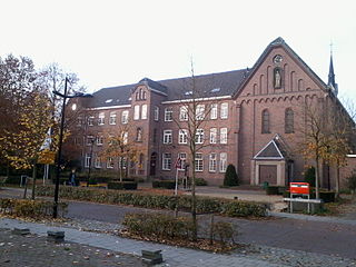
Biezenmortel is a village in the municipality Tilburg in the Dutch province North Brabant. The village had 1,465 inhabitants and 470 households in January 2020. Biezenmortel has a primary school called Franciscus and a community center called De Vorselaer. Centrally located in the village, there is a former Capuchin monastery called Beukenhof, that now serves as a group accommodation. The Sint Josephkerk, which was located inside the monastery, closed down in 2019.