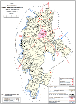
Hardoi is a city and municipal board in Hardoi district in the Indian state of Uttar Pradesh. It is the administrative headquarters of Hardoi district. It is also known as Prahalad Nagari. Hardoi is about 100 km from the state capital Lucknow and about 385 km from New Delhi. Hardoi is a temple town.
Hardoi district is a district situated in the center of Uttar Pradesh, India. The district headquarters is in the city of Hardoi. Hardoi is the third largest district of Uttar Pradesh. It falls under Lucknow division in the historical region of Awadh State.
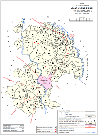
Pihani is a town and nagar palika parishad in Hardoi district of Uttar Pradesh, India. Historically, the city was a centre of sword production, leading to at least one British writer calling it "the Damascus of Oudh". Today, important industries in Pihani include jaggery and woven carpets. As of 2011, the town's population is 36,014, in 5,626 households. Pihani also serves as the headquarters of a community development block in Shahabad tehsil.
Pali is a town and nagar panchayat in Sawayajpur tehsil of Hardoi district, Uttar Pradesh, India. It is on the right bank of the Garra river, 20 miles northwest of Hardoi, Pali historically served as the seat of a pargana and was a regional political headquarters under the Nawabs of Awadh. The town's name is possibly connected to the Pal dynasty that once ruled the nearby city of Kannauj. As of 2011, the population of Pali is 18,708 in 2,949 households.

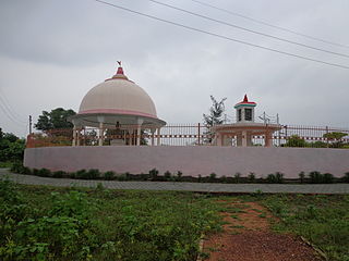
Shahabad is a town nearby Hardoi city and a municipal board in Hardoi district in the Indian state of Uttar Pradesh. At one point of time it was counted among the few biggest cities of Oudh, but declined rapidly in later period and now reduced to a town. It is the site of the Tomb of Diler Khan, a governor in the time of Shah Jahahan and Aurangzeb.There are also so many historical Mosques and Temples in Shahabad some are like Sankata Devi Temple,Khera bibi zai Mosque.

Balamau is a village in Kachhauna block of Hardoi district, Uttar Pradesh, India. It is located about a mile from the left bank of the Sai river, 25 miles from Hardoi and 4 miles southwest of the namesake Balamau station, which is actually in Kachhauna. Balamau was historically the largest settlement in the area, serving as the seat of a pargana since the reign of Akbar. As of 2011, its population is 4,749, in 1,022 households.

Todarpur, also spelled Tondarpur, is a village and corresponding community development block in Shahabad tehsil of Hardoi district, Uttar Pradesh, India. The village has several schools and one clinic. It hosts neither a haat nor a mandi. The staple crops here are wheat and rice. As of 2011, its population is 3,846, in 603 households.

Bharkhani is a village and corresponding community development block in Hardoi district of Uttar Pradesh, India. It has several schools, one clinic, and a public library, and there is a regular market as well as a weekly haat. A fair called Banshi Baba is held here on Chaitra Badi 30. The main staple crops here are wheat and rice. As of 2011, the population of Bharkhani is 5,681, in 888 households.
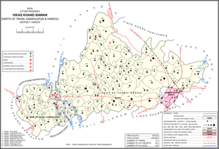
Bawan is a large village and corresponding community development block in Hardoi district of Uttar Pradesh, India. It is located 10 km west of Hardoi, on the south side of the road to Bazpur-Naktaura and the Sai Ghat. Bawan was historically the seat of a pargana since at least the time of the Mughal Emperor Akbar, and it is also the site of a mela held in honour of Darshan Debi on the first Sunday of Bhadon, at a site called the Suraj Kund. The main staple crops here are wheat, rice, and gram. Markets are held on Mondays and Thursdays. As of 2011, the population of Bawan is 13,524, in 2,230 households.

Khasaura is a large village in Harpalpur block of Hardoi district, Uttar Pradesh, India. It lies on the left bank of the Ramganga river, to the north of the road connecting Hardoi and Sandi with Farrukhabad. The village hosts a large market twice per week, on Wednesdays and Sundays. It deals mainly in vegetables.
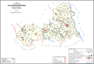
Hariyawan is a village and corresponding community development block in Hardoi district of Uttar Pradesh, India. It hosts a market on Wednesdays and Sundays. The main staple foods here are wheat and rice. As of 2011, its population is 2,997, in 508 households.
Kurseli is a large village in Hariyawan block of Hardoi district, Uttar Pradesh, India. It is located north of the city of Hardoi, to the west of the main road to Pihani. Kurseli hosts a market on Mondays and Thursdays, and the main staple foods are wheat and rice. It has several schools and one clinic, along with five practitioners of traditional medicine. The village lands extend a long way to the south, and include a chain of jhils that ultimately drain into the Sai river. As of 2011, the population of Kurseli is 10,404, in 1,936 households.

Tadiyawan, also spelled Tandiyawan, is a village and corresponding community development block in Hardoi district of Uttar Pradesh, India. Located 14 km from the city of Hardoi, it hosts a regular market and hosts a Deviji festival on Chaitra Sudi 8 dedicated to worship of the goddess Devi. The village has two primary schools but no healthcare facilities. As of 2011, the population of Tadiyawan is 5,998, in 1,079 households.
Pura Bahadur is a village in Tadiyawan block of Hardoi district, Uttar Pradesh, India. Located a few kilometres from the city of Hardoi, the village is connected to state highways and hosts a market on Wednesdays and Sundays. Pura Bahadur has two primary schools and a sub post office. There are no hospitals for humans, although there is a veterinary facility. The main staple foods are wheat and rice. As of 2011, the population of Pura Bahadur is 5,594, in 964 households.
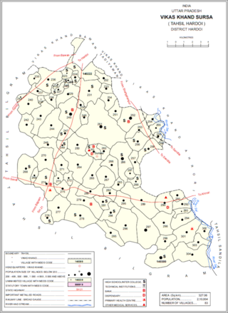
Sursa is a village and corresponding community development block in Hardoi district of Uttar Pradesh, India. Located 14 or 15 km from the city of Hardoi, the village hosts a market on Mondays and Thursdays. The village has two primary schools and one clinic. As of 2011, the population of Sursa is 2,157, in 373 households.
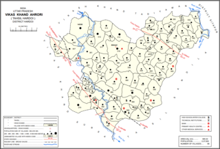
Ahrori, also spelled Ahirori, is a village and corresponding community development block in Hardoi district of Uttar Pradesh, India. Located 24 km from the city of Hardoi, it hosts a regular market and hosts a Babaji festival on Asadha Sudi 15 dedicated to worship of the goddess Devi. The village has two primary schools and one clinic, as well as a public library and a sub post office. As of 2011, the population of Ahrori is 8,382, in 1,329 households.
Kalyanmal is a village in Kothwan block of Hardoi district, Uttar Pradesh, India. Historically the seat of a pargana, Kalyanmal is located 11 km from the city of Beniganj, on the north side of the road leading to Atrauli and Bhatpurwaghat. Also close by is the road running from Sandila to Gundlamau in Sitapur district. Every Sunday during the month of Bhadon, a fair is held at Hattia Haran, a tank south of Kalyanmal where the god Rama is said to have bathed. Kalyanmal also hosts a small fair to Panchabgir Mahadeo during the month of Aghan. As of 2011, the population of Kalyanmal is 8,295, in 1,532 households.
Gaju is a village in Kachhauna block of Hardoi district, Uttar Pradesh, India. Located on the road from Balamau station to Beniganj and Sitapur, Gaju has a railway station on the Sitapur-Balamau branch line and hosts a market on Mondays and Thursdays. As of 2011, its population is 8,912, in 1,592 households.

Bharawan is a village and corresponding community development block in Sandila tehsil of Hardoi district, Uttar Pradesh, India. Located 23 km from Sandila, it hosts a market on Mondays and Thursdays and has four primary schools and one healthcare facility. The main staple foods are wheat and juwar. As of 2011, the population of Bharawan is 10,443, in 1,649 households.

Hardoi is a village in Maharajganj block of Rae Bareli district, Uttar Pradesh, India. Located on the road from Maharajganj to Bachhrawan, Hardoi historically served as the seat of a pargana and has a now-ruined fort built in the early 1400s under the Jaunpur Sultanate. As of 2011, its population is 2,308, in 415 households.