Related Research Articles

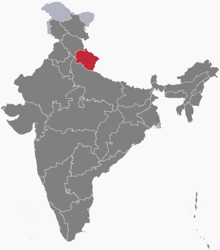
Uttarakhand, formerly known as Uttaranchal, is a state in northern India. The state is bordered by Himachal Pradesh to the northwest, Tibet to the north, Nepal to the east, Uttar Pradesh to the south and southeast, with a small part touching Haryana in the west. Uttarakhand has a total area of 53,483 km2 (20,650 sq mi), equal to 1.6% of the total area of India. Dehradun serves as the state capital, with Nainital being the judicial capital. The state is divided into two divisions, Garhwal and Kumaon, with a total of 13 districts. The forest cover in the state is 45.4% of the state's geographical area. The cultivable area is 16% of the total geographical area. The two major rivers of the state, the Ganges and its tributary Yamuna, originate from the Gangotri and Yamunotri glaciers respectively.

Pauri is a town and a municipal board in Pauri Garhwal district in the Indian state of Uttarakhand. Pauri is the seat of the Divisional Commissioner of the Garhwal Division.
Gairsain is a town in Chamoli district of the Indian state of Uttarakhand near state's summer capital Bhararisain. A town and Nagar Panchayat, Gairsain is situated at the eastern edge of the vast Dudhatoli mountain range, and is located in Chamoli district almost at the centre of the state, at a distance of approximately 250 kilometres from Dehradun. It is easily accessible from both the Garhwal and the Kumaon divisions, and in a way, acts as the bridge between the two regions. It is being considered as the future Permanent capital of Uttarakhand.
Pauri Garhwal is a district in the Indian state of Uttarakhand. Its headquarters is in the town of Pauri. It is sometimes referred to simply as Garhwal district, though it should not be confused with the larger Garhwal region of which it is only a part of.

Lansdowne is a cantonment town in Pauri Garhwal is a district in the Indian state of Uttarakhand.

Kotdwar is a city, municipal corporation in Pauri Garhwal district of Uttarakhand, India. It is just 101 km from Pauri, the district headquarter. It is the eighth-largest city in Uttarakhand. Its old name was "Kootdwar", which means the gateway of the high hill koot as Chitra koot, since it is located on the bank of river Khoh. It is situated in the southwestern part of the state and is one of the main entrance points in the state of Uttarakhand.

Srinagar is a city and municipal corporation in Pauri Garhwal district in the Indian state of Uttarakhand. It is located about 33 km from Pauri town, the administrative headquarters of Pauri Garhwal district, Uttarakhand, India.
Ramganga is a tributary of the river Ganges, originating in Uttarakhand state, India.
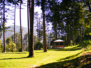
Dhanaulti is a quiet hill station at an elevation of 2286 meters above sea level, it offers panoramic views of the lofty Himalayas.

Satpuli is a town on the Meerut-Pauri highway, located approximately 50 kilometers from Kotdwar and 50 kilometers from Pauri, in Pauri Garhwal district of Uttarakhand.

Uttarakhand has a total geographic area of 53,483 km2, of which 86% is mountainous and 65% is covered by forest. Most of the northern parts of the state are part of Greater Himalaya ranges, covered by the high Himalayan peaks and glaciers, while the lower foothills were densely forested till denuded by the British log merchants and later, after independence, by forest contractors. Recent efforts in reforestation, however, have been successful in restoring the situation to some extent. The unique Himalayan ecosystem plays host to many animals, plants and rare herbs. Two of India's great rivers, the Ganges and the Yamuna take birth in the glaciers of Uttarakhand, and are fed by myriad lakes, glacial melts and streams.

Garhwal kingdom was an independent Himalayan kingdom in the current north-western Himalayan state of Uttarakhand, India, founded in 823 CE by Kanak Pal the progenitor of the Panwar dynasty that ruled over the kingdom uninterrupted until 1803 CE.
Thalisain is a town and tehsil of Pauri Garhwal district in the North Indian state of Uttarakhand. At an elevation of 1690 metres from sea level, it is situated on a gentle slope above the right bank of Nayaar (East) river. It is in the southwestern foothills of Dudhatoli Range and at a distance of 83 kilometers from Pauri town and 95 kilometers from Gairsain, the future capital of Uttarakhand.
Veer Chandra Singh Garhwali Uttarakhand University of Horticulture & Forestry, formerly Uttarakhand University of Horticulture and Forestry, is a state agricultural university located in North Indian state of Uttarakhand. The University has two campuses, one is in Bharsar town of Pauri Garhwal district and other is in Ranichauri town of Tehri Garhwal district.
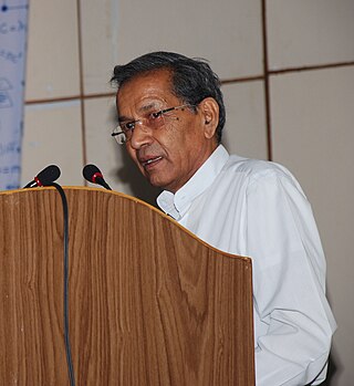
Aditya Narayan Purohit is an Indian scientist and professor who has mainly worked on ecophysiology of tree species and physiology of high altitude medicinal plants. He was the Vice-Chancellor of Hemwati Nandan Bahuguna Garhwal University and director of the university's High Altitude Plant Physiology Research Center. He was also the Director of Govind Ballabh Pant Institute of Himalayan Environment and Development from 1990 to 1995.

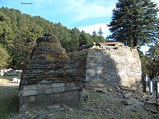
Bindeshwar Mahadev Temple, also known as Binsar Devta or simply Binsar, is an ancient Hindu rock temple dedicated to Lord Shiva, worshipped as Bindeshwar, a popular deity in this region. At an altitude of 2480 meters above mean sea level, it is situated in Bisaona village, which falls in the Chauthan region of Thalisain Block in the Pauri Garhwal District of the Indian state of Uttarakhand. This temple is set amidst dense forests of birch, deodar and rhododendron. The original temple structure held great archaeological significance, but it was demolished by politicians in order to create a new structure. The central chamber of the temple features the idols of Ganesha, Shiva-Parvati and Mahishasuramardini. A fair is organized there on Vaikuntha Chaturdashi every year.
Gujrugarhi is a place of historical importance located in Patti Gujdu of Nainidanda region in Pauri Garhwal district, Uttarakhand. The whole complex of temple and historical caves is situated on a hilltop in Deeba range at an average altitude of 2400 metres (7880 ft). The co-ordinates are 29°46'52.77"N 79° 5'18.68"E.

Diba Danda is a peak in the Patti Khatli region of Pauri Garhwal district, Uttarakhand, India. It is 2,670 metres (8,760 ft) high and is a part of the Diba Range, which forms the southern boundary of the Nayar Valley.
The following outline is provided as an overview of and topical guide to Uttarakhand:

Dudhatoli is a middle Himalayan mountain range/forest running approximately 25 km in a north–south direction, starting near Thalisain tehsil of Pauri Garhwal district in Uttarakhand, with Gairsain in Chamoli district being its western limit and Syoli-Khand region in Pauri its northernmost spur.
References
- ↑ Devy, G. N.; Davis, Geoffrey V.; Chakravarty, K. K. (12 August 2015). Knowing Differently: The Challenge of the Indigenous. Routledge. ISBN 978-1-317-32569-7.
- ↑ Journal of Himalayan Studies & Regional Development. Garhwal University, Institute of Himalayan Studies & Regional Development. 1986.
29°55′35″N79°07′16″E / 29.92639°N 79.12111°E
| | This article related to a location in the Indian state of Uttarakhand is a stub. You can help Wikipedia by expanding it. |