Related Research Articles

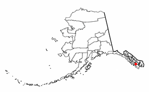
Kodiak Island Borough is a borough in the U.S. state of Alaska. At the 2020 census, the population was 13,101, down from 13,592 in 2010. The borough seat is Kodiak.
Naukati Bay is a census-designated place (CDP) in the Prince of Wales-Hyder Census Area of the Unorganized Borough of the U.S. state of Alaska. The population was 113 at the 2010 census, down from 135 in 2000.

The Alexander Archipelago is a 300-mile (480 km) long archipelago in North America lying off the southeastern coast of Alaska. It contains about 1,100 islands, the tops of submerged coastal mountains that rise steeply from the Pacific Ocean. Deep channels and fjords separate the islands and cut them off from the mainland. The islands shelter the northern part of the Inside Passage as it winds its way among them.

Shelikof Strait is a strait on the southwestern coast of the U.S. state of Alaska between the Alaska mainland to the west and Kodiak and Afognak islands to the east.
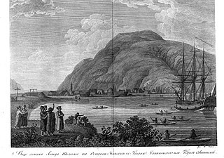
Three Saints Bay is a 9-mile (14-kilometer)-long inlet on the southeast side of Kodiak Island, Alaska, north of Sitkalidak Strait. It is 60 mi (97 km) southwest of Kodiak. The Three Saints Bay Site is an archaeological site, the location of the first Russian settlement in Alaska, Three Saints Harbor. The settlement was founded in 1784 by Grigory Shelikhov. The main settlement was moved in 1792 to Pavlovskaya Gavan, now known as the city of Kodiak. The Three Saints Bay Site was declared a National Historic Landmark by the United States in 1978.
Lützow-Holm Bay is a large bay, about 220 kilometres (120 nmi) wide, indenting the coast of Queen Maud Land in Antarctica between Riiser-Larsen Peninsula and the coastal angle immediately east of the Flatvaer Islands. It was discovered by Captain Hjalmar Riiser-Larsen in two airplane flights from his expedition vessel, the Norvegia, on February 21 and 23, 1931. The name honours Commander Finn Lützow-Holm of the Royal Norwegian Navy Air Service, a pilot for Captain Riiser-Larsen on the Aagaard in 1935.
Derbin Island is located in the Krenitzin Islands, a subgroup of the Fox Islands in the eastern Aleutian Islands, Alaska, United States. Derbin is a small island and is situated near the southwestern shore of Tigalda Island. It is measuring 840 metres (0.52 mi) long and 204 metres (0.127 mi) wide. It was named in 1935 by the United States Coast and Geodetic Survey because of its proximity to Derbin Strait, the channel between Avatanak and Tigalda islands. Derbin Strait, in turn, is derived from "Derbenskoy," the Russian name published by Father Veniaminov (1840).
Sitkalidak Island is an island in the western Gulf of Alaska in the Kodiak Island Borough of the state of Alaska, United States. It lies just off the southeast shore of Kodiak Island, across the Sitkalidak Strait from the city of Old Harbor. The island has a land area of 300 square kilometers (120 sq mi) and no resident population.
The Spiridon Peninsula is a mountainous peninsula on the northwest side of Kodiak Island, Alaska on the Shelikof Strait situated between Uganik Bay and Uyak Bay. Major promontories are Miners Point, Cape Ugat and Cape Kuliuk. Cape Ugat is the closest point on Kodiak Island to mainland Alaska.

USCGC Confidence (WMEC-619) is a United States Coast Guard medium endurance cutter.

Raspberry Island is an island of the Kodiak Archipelago located in the Gulf of Alaska in the U.S. state of Alaska. It is located two miles northwest of Whale Island, and just across the mile-wide Raspberry Strait from the southwestern end of Afognak. The island is separated from Kodiak Island by the Kupreanof Strait, with the Shelikof Strait to the northwest. Raspberry Island is 18 miles (29 km) long with a width that varies from 3 miles (4.8 km) to 8 miles (12.9 km). The highest point on the island is 3,300 ft.

The Seal Islands are a group of 12/+ islands in the Bering Sea, trending northeast 7 miles (11 km), close to the shores of Bristol Bay, Alaska, 33 miles (53 km) southwest of Port Heiden, Alaska Airfield; Bristol Bay Low.
Gilbert Strait is a strait between Trinity Island and Tower Island in the Palmer Archipelago. The strait was named by a British expedition 1828–31, under Foster, for Davies Gilbert, President of the Royal Society from 1827–30, and of the committee which formulated the objectives of the expedition. The strait was mapped by the Swedish Antarctic Expedition (SAE) of 1901–04, under Otto Nordenskjöld.

Cordova Bay is a bay in the Alexander Archipelago of southeast Alaska. It opens onto Dixon Entrance to the south, between Cape Muzon on Dall Island and Point Marsh. The name Puerto Cordova y Cordova was given by the Spanish explorer Lieutenant Don Jacinto Caamaño in 1792, in honor of Admiral Luis de Córdova y Córdova. The name was published by George Vancouver in 1798.
The Flatvaer Islands, also known as the Ongul Islands, are a group of small islands lying at the east side of the entrance of Lützow-Holm Bay, 4 km from the coastline of Antarctica. They were mapped by Norwegian cartographers from air photos taken by the Lars Christensen Expedition (LCE), 1936–37. Many of the islands and their features were subsequently named by members of the Japanese Antarctic Research Expedition (JARE); unless otherwise noted, features noted in this article were named by JARE.
Uganik is a community in the Kodiak Island Borough of the U.S. state of Alaska. Other variations of the name that have been reported are Oohanick in 1805, Ooganok in the 1880 Census, and Uganak in the 1890 Census.
American Bay is a waterway in the U.S. state of Alaska. It is located on the east side of Dall Island, facing Long Island across Kaigani Strait.
Karluk Lake, is a lake on Kodiak Island in Alaska, United States. It has no nearby settlements, being located in wilderness. Its outflow is the Karluk River.

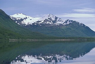
Mount Stepo is a 3,828-foot-elevation (1,167-meter) mountain summit in Alaska.
References
- ↑ Survey, U. S. Coast and Geodetic (1910). Alaska Coast Pilot Notes from Yakutat Bay to Cook Inlet and Shelikof Strait. U.S. Government Printing Office.
- ↑ "Uganik Bay". Geographic Names Information System . United States Geological Survey, United States Department of the Interior.
- ↑ Fishery Bulletin of the. U.S. Government Printing Office. 1958.
- ↑ Orth, Donald J. Dictionary of Alaska Place Names. Washington, DC
- ↑ "Topographic map showing location of Uganik". The National Map . United States Geological Survey (via MSR Maps). July 1, 1979.
- ↑ "Village Islands". Geographic Names Information System . United States Geological Survey, United States Department of the Interior.
- ↑ "Green Island". Geographic Names Information System . United States Geological Survey, United States Department of the Interior.
| International | |
|---|---|
| National | |
57°48′18″N153°30′46″W / 57.80500°N 153.51278°W
| | This article about a location in the Kodiak Island Borough, Alaska is a stub. You can help Wikipedia by expanding it. |