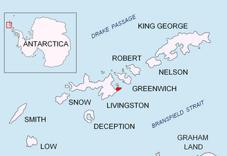
Amadok Point is a point on the south coast of Livingston Island, Antarctica which projects 400 m into the Bransfield Strait. The point was named after the Thracian King Amadokos, 415-384 BC. It is snow-free in the summer.

Melta Point is a rocky point on the coast of Hero Bay, Livingston Island, formed by an offshoot of Teres Ridge. Adjacent ice-free area 116 hectares. The point is named after the ancient Melta, ancestor of the present town of Lovech in Northern Bulgaria. This is one of the Bulgarian names bestowed on hitherto nameless geographical features by the Tangra 2004/05 Expedition.

Rila Point is a low, ice-free point on the south coast of Moon Bay, projecting 330 m west-northwestwards from Burgas Peninsula on Livingston Island in the South Shetland Islands, Antarctica, and forming the east side of the entrance to Bruix Cove. The point is named after Rila Mountain, Bulgaria.

Aytos Point is a point on the coast of Bransfield Strait, Livingston Island, Antarctica formed by an offshoot of Christoff Cliff. The point was named after the Bulgarian town of Aytos.

Kaspichan Point is a point on the southeast side of the entrance to Kramolin Cove on the southwest coast of Greenwich Island, Antarctica. Situated next west of Hebrizelm Hill, 1.4 km northwest of Triangle Point, 2 km south-southwest of Tile Ridge, and 2 km southeast of Yovkov Point. Shape enhanced by recent glacier retreat northwest of the point. Bulgarian topographic survey Tangra 2004/05. Named after the town of Kaspichan in northeastern Bulgaria.

Lavrenov Point is a point on the north coast of Robert Island, South Shetland Islands forming the east side of the entrance to Yundola Cove. Situated 2.7 km west of Newell Point and 2.6 km southeast of Catharina Point. Bulgarian early mapping in 2008. Named after the Bulgarian painter Tsanko Lavrenov (1896–1978).

Garmen Point is a point on the northwest coast of Smith Island, South Shetland Islands situated 13.65 km north-northeast of Cape James, 6.12 km south-southwest of Markeli Point and 19.65 km southwest of Cape Smith. Formed by an offshoot of Mount Foster. Bulgarian early mapping in 2008. Named after the settlement of Garmen in southwestern Bulgaria.

Markeli Point is a point on the northwest coast of Smith Island in the South Shetland Islands, Antarctica, projecting 1.2 km west-southwestwards into Drake Passage. Situated on the north side of the entrance to Cabut Cove 14.5 km southwest of Cape Smith, 2 km south-southwest of Gregory Point and 19.8 km north-northeast of Cape James. Bulgarian early mapping in 2009. Named after the medieval fortress of Markeli in southeastern Bulgaria.

Delyan Point is a point on the northwest coast of Smith Island, South Shetland Islands forming the northeast side of the entrance to Vedena Cove. Situated 4 km west-southwest of Cape Smith, 10.66 km northeast of Markeli Point and 1.4 km northwest of Matochina Peak. Bulgarian early mapping in 2009. Named after Peter Delyan – Czar Peter II of Bulgaria, 1040-1041 AD.

Kardzhali Point is the rocky point forming the south side of the entrance to Ograzhden Cove on the northwest coast of Ray Promontory of Byers Peninsula, Livingston Island in the South Shetland Islands, Antarctica. It is situated 680 m south of Essex Point, 1.23 km east-northeast of Isbul Point and 1.98 km east-northeast of Start Point.

Zavala Island is an ice-free island in the Dunbar group off the northwest coast of Varna Peninsula on Livingston Island in the South Shetland Islands, Antarctica. It is extending 700 by 250 m, with surface area 14 hectares. The area was visited by early 19th century sealers.

Yasen Point is the sharp, rocky point on the south coast of Livingston Island in the South Shetland Islands, Antarctica, forming the west side of the entrance to Mateev Cove. Situated on the east side of the small ice-free promontory ending in Hannah Point to the west.

Brusen Point is the narrow rocky point projecting 200 m in north-northwest direction and forming the north extremity of Greenwich Island in the South Shetland Islands, Antarctica.

Shipot Point is the ice-free point on the northwest coast of Robert Island in the South Shetland Islands projecting 630 m northwards, and together with Osenovlag Island and Svetulka Island forming the southwest side of Clothier Harbour. The area was visited by early 19th century sealers.

Varbak Point is the ice-covered point on the southwest side of the entrance to Pakusha Cove on the southeast coast of Smith Island in the South Shetland Islands, Antarctica. The point is named after the settlement of Varbak in Northeastern Bulgaria.

Medovene Point is the ice-covered point on the northeast side of the entrance to Zapalnya Cove on the southeast coast of Smith Island in the South Shetland Islands, Antarctica. The point is named after the settlement of Medovene in Northeastern Bulgaria.

Razdel Point is the ice-covered point on the southwest side of the entrance to Zapalnya Cove and northeast side of the entrance to Nikolov Cove on the southeast coast of Smith Island in the South Shetland Islands, Antarctica. The point is named after the settlements of Razdel in Northeastern and Southeastern Bulgaria.

Velikan Point is the ice-covered point on the southwest side of the entrance to Nikolov Cove on the southeast coast of Smith Island in the South Shetland Islands, Antarctica. The point is named after the settlement of Velikan in Southern Bulgaria.

Skalina Point is the ice-covered point on the southwest side of the entrance to Yarebitsa Cove on the southeast coast of Smith Island in the South Shetland Islands, Antarctica. It is named after the settlement of Skalina in Southern Bulgaria.


