Smirnenski Point

Last updated
Location of Robert Island in the South Shetland Islands. Robert-Island-location-map.png
Location of Robert Island in the South Shetland Islands.
Topographic map of Livingston Island, Greenwich, Robert, Snow and Smith Islands. Livingston-Island-Map-2010.jpg
Topographic map of Livingston Island, Greenwich, Robert, Snow and Smith Islands.

Smirnenski Point (Bulgarian : нос Смирненски, ‘Nos Smirnenski’ \'nos 'smir-nen-ski\) is a narrow, ice-free point on the east coast of Robert Island projecting 1.1 km into Nelson Strait in the South Shetland Islands, Antarctica, and forming the northwest side of the entrance to Garnya Cove.

Bulgarian language South Slavic language

Bulgarian, is an Indo-European language and a member of the Southern branch of the Slavic language family.

Robert Island island of the South Shetland Islands in the Southern Ocean

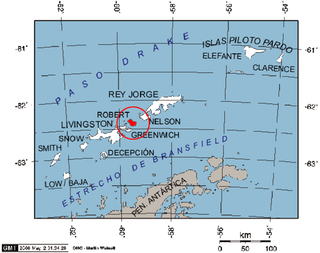
Robert Island or Mitchells Island or Polotsk Island or Roberts Island is an island 11 miles (18 km) long and 8 miles (13 km) wide, situated between Nelson Island and Greenwich Island in the South Shetland Islands, Antarctica. Robert Island is located at 62°24′S59°30′W. Surface area 132 km2 (51 sq mi). The name "Robert Island" dates back to around 1821 and is now established in international usage.

Nelson Strait (South Shetland Islands)

Nelson Strait is the 9 km long and 9.8 km wide strait lying between Robert Island and Nelson Island in the South Shetland Islands, Antarctica. The strait was explored by early 19th century sealers and first charted by Nathaniel Palmer in 1821. While it had a variety of different names in the past, the present name — probably taken from the adjacent Nelson Island — has become well established in international usage.

It is situated 1.2 km northwest of Perelik Point, 4.4 km north-northwest of Batuliya Point, 1.42 km east of Treklyano Island, 4.7 km east of Ugarchin Point and 8.11 km southeast of Newell Point. Bulgarian early mapping in 2009.

Perelik Point

Perelik Point is a point on the north side of the entrance to Kozloduy Cove and the southeast side of the entrance to Garnya Cove on the east coast of Robert Island in the South Shetland Islands, Antarctica.

Batuliya Point

Batuliya Point is an ice-free tipped point forming the east extremity of Robert Island and the south side of the entrance to Tsepina Cove in the South Shetland Islands, Antarctica.

Treklyano Island island of the South Shetland Islands in the Southern Ocean

Treklyano Island is an island off the northeast coast of Robert Island, South Shetland Islands Extending 330 by 250 m, with a low rocky formation projecting 300 m (330 yd) northeastwards, the island emerged as a distinct geographical entity following the retreat of Robert Island's ice cap in the late 20th century. Named after the settlement of Treklyano in western Bulgaria.

The feature is named after the Bulgarian poet Hristo Smirnenski (1898–1923).

Hristo Smirnenski Bulgarian writer

Hristo Smirnenski, born Hristo Izmirliev, was a Bulgarian poet and prose writer who joined the Bulgarian Communist Party and whose works championed socialist ideals in a light-hearted and humane style. He died at the age of 25, leaving a well regarded body of work produced over a mature career of only three years.

Coordinates: 62°22′07″S59°22′45″W / 62.36861°S 59.37917°W / -62.36861; -59.37917

Geographic coordinate system Coordinate system

A geographic coordinate system is a coordinate system that enables every location on Earth to be specified by a set of numbers, letters or symbols. The coordinates are often chosen such that one of the numbers represents a vertical position and two or three of the numbers represent a horizontal position; alternatively, a geographic position may be expressed in a combined three-dimensional Cartesian vector. A common choice of coordinates is latitude, longitude and elevation. To specify a location on a plane requires a map projection.

Maps

International Standard Book Number Unique numeric book identifier

The International Standard Book Number (ISBN) is a numeric commercial book identifier which is intended to be unique. Publishers purchase ISBNs from an affiliate of the International ISBN Agency.

Related Research Articles

Murgash Glacier

Murgash Glacier is the 3.4 km long and 3.2 km wide glacier on Greenwich Island in the South Shetland Islands, Antarctica situated southeast of Yakoruda Glacier, south of Teteven Glacier, southwest of Traub Glacier and west-northwest of Bravo Glacier. It is bounded by Lloyd Hill on the northwest, Tile Ridge on the east and Hebrizelm Hill on the southeast, and drains southwards into Kramolin Cove in McFarlane Strait between Yovkov Point and Kaspichan Point.

Pavlikeni Point

Pavlikeni Point projects 600 m from the north coast of Greenwich Island in the South Shetland Islands, Antarctica and is snow-free in summer. It is named after the Bulgarian town of Pavlikeni.

Rila Point

Rila Point is a low, ice-free point on the south coast of Moon Bay, projecting 330 m west-northwestwards from Burgas Peninsula on Livingston Island in the South Shetland Islands, Antarctica, and forming the east side of the entrance to Bruix Cove. The point is named after Rila Mountain, Bulgaria.

Yovkov Point

Yovkov Point is a point on the southwest coast of Greenwich Island, Antarctica projecting 150 m southwards into McFarlane Strait, forming the northwest side of the entrance to Kramolin Cove. Formed as a result of Murgash Glacier's retreat in the late 20th and early 21st century. The feature is named after the famous Bulgarian writer Yordan Yovkov (1880–1937).

Kaspichan Point

Kaspichan Point is a point on the southeast side of the entrance to Kramolin Cove on the southwest coast of Greenwich Island, Antarctica. Situated next west of Hebrizelm Hill, 1.4 km northwest of Triangle Point, 2 km south-southwest of Tile Ridge, and 2 km southeast of Yovkov Point. Shape enhanced by recent glacier retreat northwest of the point. Bulgarian topographic survey Tangra 2004/05. Named after the town of Kaspichan in northeastern Bulgaria.

Aprilov Point

Aprilov Point is a point on the north coast of Greenwich Island, Antarctica situated 6.9 km east of Duff Point, 2.1 km east-southeast of Kabile Island, 2.2 km east-northeast of Crutch Peaks, 1.8 km south of Ongley Island, 5.5 km west of Agüedo Point, and 2.3 km north-northwest of Sevtopolis Peak. Forming the east side of the entrance to Haskovo Cove and the west side of the entrance to Skaptopara Cove.

Beron Point

Beron Point is a point on the southwest coast of Robert Island, Antarctica situated 4.5 km southeast of Negra Point, 1.7 km west of Bajo Nunatak, 1.8 km west-northwest of Zahari Point, and 3.7 km northwest of Edwards Point, as well as 5 km northeast of Ash Point on Greenwich Island. Its shape has been enhanced by a recent glacier retreat north-northwest of the point. It was named after the prominent Bulgarian scientist and educator Dr. Petar Beron (1795–1871).

Zahari Point

Zahari Point is an ice-free point on the southwest coast of Robert Island in the South Shetland Islands, Antarctica forming the northwest side of the entrance to Micalvi Cove. Ice-free surface area 21 hectares. The feature is named after the Bulgarian writer and historiographer Zahari Stoyanov (1850–1889).

Ficheto Point

Ficheto Point is an ice-free point on the northeast coast of Varna Peninsula, Livingston Island, Antarctica forming the southeast side of the entrance to Dragon Cove. Channel Rock is lying in the adjacent northwestern part of McFarlane Strait, 1.3 km (0.81 mi) northeast of Ficheto Point and 920 m (1,010 yd) south-southwest of Meade Islands. The area was visited by 19th century sealers.

Makresh Rocks

Makresh Rocks are a group of rocks situated 1.8 km (1.12 mi) northeast of Treklyano Island off the northeast coast of Robert Island, South Shetland Islands. Extending 600 m (656 yd) in west-southwest to east-northeast direction, and 270 m (295 yd) in northwest-southeast direction. The solitary Salient Rock62°21′24″S59°20′59″W is lying 1.73 km (1.07 mi) east of the midpoint of Makresh Rocks and 2 km (1.24 mi) northeast of Smirnenski Point.

Ugarchin Point headland of Robert Island in the Southern Ocean

Ugarchin Point is a point on the northeast coast of Robert Island in the South Shetland Islands, Antarctica projecting 300 m into Nelson Strait. Named after the town of Ugarchin in northern Bulgaria.

Pordim Islands

Pordim Islands are two adjacent islands situated 870 m (950 yd) east-northeast of Heywood Island and 2.1 km (1.3 mi) northwest of Catharina Point on Robert Island, South Shetland Islands. Extending 960 m (1,050 yd) in east-southeast to west-northwest direction. The larger islet has a surface area of 10 hectares. Bulgarian early early mapping in 2009. Named after the town of Pordim in northern Bulgaria.

Gostun Point

Gostun Point is the ice-free point on the north coast of Snow Island in the South Shetland Islands, Antarctica situated 2.4 km west-northwest of Karposh Point, and 2.45 km east-southeast of Cape Timblón.

Somovit Point

Somovit Point is a point on the east coast of Robert Island in the South Shetland Islands, Antarctica projecting 500 m into Bransfield Strait between Kruni Cove and Tsepina Cove.

Mount Reina Sofía mountain in Livingston Island, South Shetland Islands, Antarctica

Mount Reina Sofía is the mostly ice-free peak rising to 275 m on Hurd Peninsula, Livingston Island in the South Shetland Islands, Antarctica and surmounting Johnsons Glacier to the east and northeast, and the Spanish Antarctic base Juan Carlos Primero to the north-northwest.

Priboy Rocks

Priboy Rocks is the group of rocks off the east coast of Robert Island in the South Shetland Islands, Antarctica, extending 1.65 km (1.03 mi) in east-west direction and 1.2 km (0.75 mi) in north-south direction.

Brusen Point

Brusen Point is the narrow rocky point projecting 200 m in north-northwest direction and forming the north extremity of Greenwich Island in the South Shetland Islands, Antarctica.

Garnya Cove

Garnya Cove is a 1.2 km (0.75 mi)-wide cove on the east coast of Robert Island in the South Shetland Islands, Antarctica. It is entered southeast of Smirnenski Point and northwest of Perelik Point.

References

Scientific Committee on Antarctic Research organization

The Scientific Committee on Antarctic Research (SCAR) is an interdisciplinary body of the International Council for Science (ICSU).

Composite Gazetteer of Antarctica The authoritative international gazetteer containing all the Antarctic toponyms

The Composite Gazetteer of Antarctica (CGA) of the Scientific Committee on Antarctic Research (SCAR) is the authoritative international gazetteer containing all the Antarctic toponyms published in national gazetteers, plus basic information about those names and the relevant geographical features. The Gazetteer includes also parts of the International Hydrographic Organization (IHO) General Bathymetric Chart of the Oceans (GEBCO) gazetteer for under-sea features situated south of 60° south latitude.

Antarctic Place-names Commission

The Antarctic Place-names Commission was established by the Bulgarian Antarctic Institute in 1994, and since 2001 has been a body affiliated with the Ministry of Foreign Affairs of Bulgaria.


This article includes information from the Antarctic Place-names Commission of Bulgaria which is used with permission.