The Lower Peninsula of Michigan – also known as Lower Michigan – is the larger, southern and less elevated of the two major landmasses that make up the U.S. state of Michigan; the other being the Upper Peninsula, which is separated by the Straits of Mackinac. It is surrounded by water on all sides except its southern border, which it shares with Indiana and Ohio.

Lake and Peninsula Borough is a borough in the state of Alaska. As of the 2020 census, the population was 1,476, down from 1,631 in 2010. The borough seat of King Salmon is located in neighboring Bristol Bay Borough, although is not the seat of that borough. The most populous community in the borough is the census-designated place of Port Alsworth. With an average of 0.017 inhabitants per square kilometre, the Lake and Peninsula Borough is the least densely populated organized county-equivalent in the United States; only the unorganized Yukon-Koyukuk Census Area has a lower density.

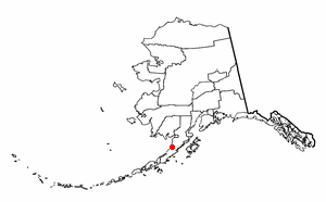
Pilot Point is a city in Lake and Peninsula Borough, Alaska, United States, on the Alaska Peninsula. As of the 2020 census, the population of the city was 70, up from 68 in 2010.
Ugashik is a census-designated place (CDP) in Lake and Peninsula Borough, Alaska, United States. The population was 4 at the 2020 census, down from 12 in 2010.

This is a list of the extreme points of North America: the points that are highest and lowest, and farther north, south, east or west than any other location on the continent. Some of these points are debatable, given the varying definitions of North America.
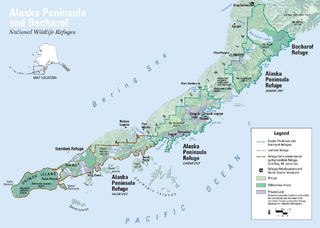
The Alaska Peninsula is a peninsula extending about 497 mi (800 km) to the southwest from the mainland of Alaska and ending in the Aleutian Islands. The peninsula separates the Pacific Ocean from Bristol Bay, an arm of the Bering Sea.
This is a list of the extreme points of The Americas, the points that are farther north, south, east or west than any other location on the continent. The continent's southernmost point is often said to be Cape Horn, which is the southernmost point of the Chilean islands. The Americas cross 134° of longitude east to west and 124° of latitude north to south.
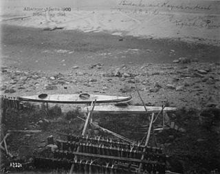
The Ugashik River is a stream, 43 miles (69 km) long, on the Alaska Peninsula of the U.S. state of Alaska. It flows from headwaters near Lower Ugashik Lake and empties into Ugashik Bay, an estuary of the Bering Sea's Bristol Bay.
Smoky Point is a point of land in the U.S. state of Alaska, located at 57°36′44″N157°41′24″W, where Ugashik Bay joins the much larger Bristol Bay. The most easily distinguishable landmark is the United States Coast Guard lighthouse which is visible to mariners on the eastern shore of Bristol Bay and all of Ugashik Bay. Located 10 to 12 miles from Cape Grey, the bluff at Smoky Point has long been considered the northern entrance point to Ugashik River.
Ugashik Bay is a bay of the Bering Sea in the U.S. state of Alaska. It is an elongated, comma-shaped estuary formed where the Ugashik River empties into Bristol Bay, on the western coast of the Alaska Peninsula.
Cape Greig is a geographical feature of the Alaska Peninsula in the U.S. state of Alaska, where a 290-foot ridge juts into the Bering Sea. It is located on the Bristol Bay coast eight miles north of Smoky Point and 32 miles south of Goose Point.
Dago CreekIPA:[/kuixaːäq/] (Sugpiaq: Kuigaa'aq) is a stream, 50 miles (80 km) long, on the Alaska Peninsula in the U.S. state of Alaska. Beginning in a small lake 16 miles (26 km) southeast of Egegik, it meanders southwest across the flats to enter Ugashik Bay 3 miles (5 km) southeast of Smoky Point.

Southwest Alaska is a region of the U.S. state of Alaska. The area is not exactly defined by any governmental administrative region(s); nor does it always have a clear geographic boundary.
The King Salmon River is a 35-mile (56 km) tributary of the Ugashik River in the U.S. state of Alaska. Beginning at Mother Goose Lake in the Aleutian Range, it flows northwest to meet the larger river near the upper reaches of Ugashik Bay. The lake and the upper course of the King Salmon lie within the Alaska Peninsula National Wildlife Refuge. The river's gravel bottom and braided channels are ideal for the many king salmon that spawn in its waters, but they limit navigation to small skiff.
The Dog Salmon River is a 70-mile (110 km) tributary of the Ugashik River in the U.S. state of Alaska. Beginning on the flanks of Mount Kialagvik, it flows northwest through the Alaska Peninsula National Wildlife Refuge to meet the larger river 4 miles (6 km) southwest of Ugashik, at the head of Ugashik Bay, an arm of Bristol Bay.
The King Salmon River is a 45-mile (72 km) tributary of the Nushagak River in southwest Alaska, United States. It flows eastward from headwaters 60°17′06″N158°28′33″W at a small unnamed lake in the Taylor Mountains to its confluence with the larger river about 220 miles (354 km) north of Nushagak Bay.

Michigan consists of two peninsulas surrounded primarily by four of the Great Lakes and a variety of nearby islands. The Upper Peninsula is bounded on the southwest by Wisconsin, and the Lower Peninsula is bounded on the south by Indiana and Ohio. Both land masses are also separated from the Canadian province of Ontario by waterways of the Great Lakes, and from each other by the Straits of Mackinac. Because its land is largely surrounded by the Great Lakes, which flow into the Saint Lawrence River, Michigan is the only U.S. state whose streams and rivers are almost entirely within the Great Lakes-St. Lawrence watershed.
Ugashik Bay Airport is a public use airport located 11 nautical miles south-southwest of the central business district of Pilot Point, near Ugashik Bay in the Lake and Peninsula Borough of the U.S. state of Alaska. It is owned by the Bureau of Land Management.
Ugashik Airport is a state-owned public-use airport located one nautical mile (2 km) north of the central business district of Ugashik, in the Lake and Peninsula Borough of the U.S. state of Alaska. It is included in the National Plan of Integrated Airport Systems for 2011–2015, which categorized it as a general aviation airport.
Lakes named Summit Lake in Alaska include:

