
Târnăveni is a city in Mureș County, central Romania. It lies on the Târnava Mică River in central Transylvania. The city administers three villages: Bobohalma (Bábahalma), Botorca (Őrhegy), and Cuștelnic (Csüdőtelke); the last was part of Gănești Commune until 2002.

Sucidava was a Dacian and Daco-Roman city situated in Corabia, Romania, on the north bank of the Danube. It developed from the 270s AD and especially after the construction of Constantine's Bridge the northern side of which it protected.

The Fortress of Deva is a fortress located in the city of Deva, Hunedoara County, Romania, on top of a volcanic hill.

Located in present-day Romania, Limes Porolissensis was the frontier of the Roman empire in Dacia Porolissensis, the northernmost of the three Dacian provinces. It was a defensive line dating from the 2nd century AD after the Conquest of Dacia up to the retreat of the Roman army from the region. The Limes was a complex network of over 200 observation towers, fortlets, palisades and ditches, and forts disposed in an arched line following the highland chain of the Meseș Mountains over 200 km from the Apuseni Mountains to Bistrița Mountains, and required as many as 16,000 soldiers to man and defend.
Cetatea Pătulului is a Roman-Byzantine fortification, identified by some with the Roman name FLAVIANA, situated 2 km northwest of Cochirleni, Rasova commune, Romania.
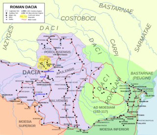
Limes Transalutanus is the modern name given to a fortified frontier system of the Roman Empire, built on the western edge of Teleorman's forests as part of the Dacian Limes in the Roman province of Dacia, modern-day Romania.
Amutria was a Dacian town close to the Danube and included in the Roman road network, after the conquest of Dacia.
Capidava was originally an important Geto-Dacian centre on the right bank of the Danube. After the Roman conquest, it became a civil and military centre in the province of Moesia Inferior and part of the defensive frontier system of the Moesian Limes along the Danube.

Sacidava was an ancient Getic settlement on the Danube, between Durostorum and Axiopolis, located near the modern village of Izvoarele, in Romania.

Sacidava was a fort in the Roman province of Moesia near the Getic settlement and later Roman city of Sacidava, Moesia that developed around the fort. It is located at Musait between the villages of Rasova and Dunareni, on a high hill on the right bank of the Danube. It is included in the Tabula Peutingeriana as Sagadava and the Notitia Dignitatum as Sacidava.

Carsium was a fort in the Roman province of Moesia in the 1st century AD whose remains are still visible. It was part of the defensive frontier system of the Limes Moesiae along the Danube.
The castra of Hinova was a Late Roman fort built north of the Lower Danube in the 3rd or 4th century AD. The fort was destroyed for the first time between 378 - 379 AD. In the beginning of 5th century the fort was destroyed by Huns and finally abandoned by Romans.

The castra of Orheiu Bistriței was a fort in the Roman province of Dacia. It was built in the 2nd century AD. Archaeological research also identified the nearby vicus. The castra and the nearby settlement were both abandoned in the 3rd century AD. The ruins of the fort are located in Orheiu Bistriței.
Castra of Reci was a fort in the Roman province of Dacia.
The castra of Bucium was a fort in the Roman province of Dacia in the 2nd and 3rd centuries AD. Its ruins are located in Bucium.

Apulum was a legionary fortress in the Roman province of Dacia from the 2nd to 4th centuries AD, located in today's Alba Iulia, Romania.

Piatra Roșie, which means Red Rock, was a Dacian hill fort two days march to the west from Costești-Cetățuie fortress, at Luncani in Boșorod commune, Hunedoara County. It was built in two phases. In the first phase a long rectangular main citadel was built at the height of land with watch towers on each end and two outlying watch towers. Later the larger area inside the watch towers was enclosed with walls. It appears that the hilltop was flattened in the process in order to produce a usable space.

Castra of Răcarii de Jos is an ancient Roman fort near the town of Răcari, near Brădești, Dolj county, Romania. The fort is on the left terrace of the River Jiu and about 70 m SW of the railway station. It probably guarded a military port on the Jiu River.

Rupea Fortress is a medieval fortress built by Transylvanian Saxons in the Kingdom of Hungary and first mentioned by a 1324 document. It is situated on a 120 m high basalt cliff, to the west of the Transylvanian town of Rupea in Romania. The fortress is located on DN13, 70 km from Brașov, on the road to Sighișoara. Following a period of restoration from 2010 to 2013, the fortress had over 10,000 monthly visitors by 2014.

The Medieval Seat Fortress of Suceava is a fortified castle in the middle-sized town of Suceava, the county seat town of Suceava County, situated in the historical regions of Bukovina and Moldavia, northeastern Romania.


