Related Research Articles
A caldera is a large cauldron-like hollow that forms shortly after the emptying of a magma chamber in a volcanic eruption. An eruption that ejects large volumes of magma over a short period of time can cause significant detriment to the structural integrity of such a chamber, greatly diminishing its capacity to support its own roof, and any substrate or rock resting above. The ground surface then collapses into the emptied or partially emptied magma chamber, leaving a large depression at the surface. Although sometimes described as a crater, the feature is actually a type of sinkhole, as it is formed through subsidence and collapse rather than an explosion or impact. Compared to the thousands of volcanic eruptions that occur over the course of a century, the formation of a caldera is a rare event, occurring only a few times within a given window of 100 years. Only eight caldera-forming collapses are known to have occurred between 1911 and 2018, with a caldera collapse at Kīlauea, Hawaii in 2018. Volcanoes that have formed a caldera are sometimes described as "caldera volcanoes".

Lake Toba is a large natural lake in North Sumatra, Indonesia, occupying the caldera of the Toba supervolcano. The lake is located in the middle of the northern part of the island of Sumatra, with a surface elevation of about 900 metres (2,953 ft), the lake stretches from 2.88°N 98.52°E to 2.35°N 99.1°E. The lake is about 100 kilometres long, 30 kilometres (19 mi) wide, and up to 505 metres (1,657 ft) deep. It is the largest lake in Indonesia and the largest volcanic lake in the world. Toba Caldera is one of twenty geoparks in Indonesia, and was recognised in July 2020 as one of the UNESCO Global Geoparks.
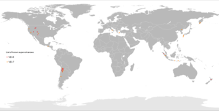
A supervolcano is a volcano that has had an eruption with a volcanic explosivity index (VEI) of 8, the largest recorded value on the index. This means the volume of deposits for such an eruption is greater than 1,000 cubic kilometers.
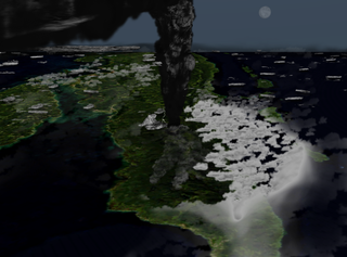
The Toba eruption was a supervolcanic eruption that occurred about 74,000 years ago during the Late Pleistocene at the site of present-day Lake Toba in Sumatra, Indonesia. It was the last in a series of at least four caldera-forming eruptions at this location, with the earlier known caldera having formed around 1.2 million years ago. This last eruption had an estimated VEI of 8, making it the largest-known explosive volcanic eruption in the Quaternary, and one of the largest known explosive eruptions in the Earth's history.

The Ring of Fire is a tectonic belt of volcanoes and earthquakes.
Toba may refer to:

The Yellowstone Caldera, sometimes referred to as the Yellowstone Supervolcano, is a volcanic caldera and supervolcano in Yellowstone National Park in the Western United States. The caldera and most of the park are located in the northwest corner of the state of Wyoming. The caldera measures 43 by 28 miles, and postcaldera lavas spill out a significant distance beyond the caldera proper.
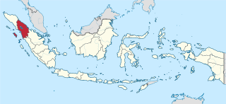
North Sumatra, also called North Sumatra Province, is a province of Indonesia located in the northern part of the island of Sumatra, just south of Aceh. Its capital and largest city is Medan on the east coast of the island. It is bordered by Aceh on the northwest and Riau and West Sumatra on the southeast, by coastlines located on the Indian Ocean to the west, and by the Strait of Malacca to the east.

Samosir, or Samosir Island, is a large volcanic island in Lake Toba, located in North Sumatra Province on the island of Sumatra in Indonesia. Administratively, Samosir Island is governed as six of the nine districts within Samosir Regency. The lake and island were formed after the eruption of the Toba supervolcano some 75,000 years ago.

A lake island is any landmass within a lake. It is a type of inland island. Lake islands may form a lake archipelago.

Humbang Hasundutan Regency is a landlocked regency in North Sumatra province of Indonesia. In the east of the regency, Baktiraja District stretches along a short part of the southern shore of Lake Toba in North Sumatra. The regency covers an area of 2,502.71 km2, and it had a population of 171,650 at the 2010 census and 197,751 at the 2020 census; the official estimate as at mid 2023 was 204,700. Its seat is the town of Dolok Sanggul. To the north is Samosir Regency and Pakpak Bharat Regency, to the east is North Tapanuli Regency, and to the west and south is Central Tapanuli Regency, and beyond the latter the Indian Ocean.

Samosir Regency is an inland regency in North Sumatra. It was created on 18 December 2003 by splitting away the western districts of the former Toba Samosir Regency. The regency covers a land area of 1,444.25 square kilometres, including the whole of Samosir Island in the inland sea of Lake Toba. It had a population of 119,653 at the 2010 census and 136,441 at the 2020 Census; the official estimate for mid 2023 was 141,333 - comprising 70,648 males and 70,685 females. Its administrative seat is the town of Pangururan on the west coast of Samosir Island.

Simalungun Regency is a regency in North Sumatra Province of Indonesia. Its seat was formerly at Pematangsiantar, but this city was under Law No.15 of 10 March 1986 was separated from the Regency and made into an independent city (kota), although it remains geographically surrounded by the regency, whose new administrative seat is at Raya, while the regency's two most populous districts are Bandar and Siantar. The regency now covers an area of 4,372.5 square kilometres, and at the 2010 census it had a population of 817,720; at the 2020 Census this had risen to 990,246, of whom 497,314 were males and 492,932 were females; the official estimate as at mid 2023 was 1,035,920 - comprising 521,262 males and 514,658 females.
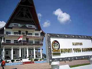
Toba Regency is a landlocked regency in North Sumatra. Its seat is Balige. The regency covers an area of 2,021.8 square kilometres; it had a population of 173,129 at the 2010 census and 206,199 at the 2020 Census; the official estimate as at mid 2023 was 213,850. Although landlocked, the regency includes the eastern shore of the vast inland Lake Toba.

Parapat is a small town and port in North Sumatra province on the edge of Lake Toba, on the Uluan Peninsula where it forms the closest point to Samosir Island. It is the primary transit point by ferry for visitors going across the lake to Samosir Island. Administratively it is part of Simalungun Regency.

Toba Batak people are the largest ethnic group of the Batak peoples of North Sumatra, Indonesia. The general term ‘Batak’ is sometimes used to refer to the Batak Toba people, for one thing because the Toba people are the largest sub-group of the Batak ethnicity, for another because they tend to self-identify as merely Batak instead of ‘Toba’ or ‘Batak Toba’, contrary to the habit of the Karo, Mandailing, Simalungun, Pakpak communities who commonly self-identify with their respective sub-groups.

A volcanic crater lake is a lake in a crater that was formed by explosive activity or a collapse during a volcanic eruption.
A recursive island or lake, also known as a nested island or lake, is an island or a lake that lies within a lake or an island. For the purposes of defining recursion, small continental land masses such as Madagascar and New Zealand count as islands, while large continental land masses do not. Islands found within lakes in these countries are often recursive islands because the lake itself is located on an island.
References
- ↑ "Super Volcano Lake Toba". www.solcomhouse.com. Archived from the original on 2007-03-07.