Umba River (Russia)

Last updated
Umba
Russian: Умба
Umba.jpg
Location
Country Russia
Region Murmansk Oblast
Physical characteristics
Source 
 - location Lake Umbozero
 - elevation149 m (489 ft)
Mouth  
 - location Kandalaksha Gulf
 - elevation0 m (0 ft)
Length123 km (76 mi)
Discharge 
 - locationPayalka, 3.7 km from the mouth
 - average78.2 m3/s (2,760 cu ft/s)
Basin features
Basin size6,470 km2 (2,500 sq mi)
Tributaries 
 - left Vyala, Muna
 - right Kana

Umba (Russian : Умба) is a 123 km long river on the Kola Peninsula, Murmansk Oblast, Russia.

Russian language East Slavic language

Russian is an East Slavic language, which is official in the Russian Federation, Belarus, Kazakhstan and Kyrgyzstan, as well as being widely used throughout Eastern Europe, the Baltic states, the Caucasus and Central Asia. It was the de facto language of the Soviet Union until its dissolution on 25 December 1991. Although, nowadays, nearly three decades after the breakup of the Soviet Union, Russian is used in official capacity or in public life in all the post-Soviet nation-states, as well as in Israel and Mongolia, the rise of state-specific varieties of this language tends to be strongly denied in Russia, in line with the Russian World ideology.

Kola Peninsula peninsula in the northwest of Russia

The Kola Peninsula is a peninsula in the far northwest of Russia. Constituting the bulk of the territory of Murmansk Oblast, it lies almost completely inside the Arctic Circle and is bordered by the Barents Sea in the north and the White Sea in the east and southeast. The city of Murmansk is the most populous human settlement on the peninsula, with a population of over 300,000 as of the 2010 Census.

Murmansk Oblast First-level administrative division of Russia

Murmansk Oblast is a federal subject of Russia, located in the northwestern part of the country. Its administrative center is the city of Murmansk. As of the 2010 Census, its population was 795,409.

Contents

Geography

The river's source is Lake Umbozero, 100 km northeast of Kandalaksha, located between the mountains of the Khibiny Massif and the Lovozero Tundras on the Kola Peninsula. From there it flows south, through a landscape of forests and hills. The river alternates between rapids and more quiet sections, and it flows through several lakes, the largest of which is Lake Kanozero.

Umbozero Lake is located in Murmansk Oblast of Russia, between the Khibiny on the west and Lovozero Tundras on the east. Area is 422 km², average depth is 15 m, maximum is 115. The lake freezes from the end of October. Its largest island is Sarvanovsky. Three kinds of fish are found in the lake.

Kandalaksha Town in Murmansk Oblast, Russia

Kandalaksha is a town in Kandalakshsky District of Murmansk Oblast, Russia, located at the head of Kandalaksha Gulf on the White Sea, north of the Arctic Circle. Population: 35,654 (2010 Census); 40,564 ; 54,080 (1989 Census).

Lake Kanozero lake in Russia

Kanozero is a lake on the Umba River in Murmansk Oblast in Russia.

The river exits from Lake Kanozero through two separate outlet channels, about five kilometers apart. The outlets are called the Kitsa and the Rodvinga, and the latter again divides forming yet another channel called the Nizma. The Kitsa and Rodvinga rejoins in Lake Ponchozero, below which the river is again called the Umba, and it is rejoined by the Nizma a few kilometers further downstream.

Lake Ponchozero lake

Ponchozero is a lake on the Umba River in Murmansk Oblast, Russia. It is 10 km long and 3 km wide.

The river empties into the Kandalaksha Gulf at the urban-type settlement of Umba.

Kandalaksha Gulf bay

The Kandalaksha Gulf, Finnish: Kantalahti) is located in the Republic of Karelia, and Murmansk Oblast in northwestern Russia. Forming the north-western corner of the White Sea, it is one of four large bays and gulfs of this sea, the others being the Onega Bay (south-west), the Dvina Bay (south), and the Mezen Bay.

Urban-type settlement is an official designation for a semi-urban settlement, used in several Eastern European countries. The term was historically used in Bulgaria, Poland, and the Soviet Union, and remains in use today in 10 of the post-Soviet states.

Umba, Russia Urban-type settlement in Murmansk Oblast, Russia

Umba is an urban locality in Tersky District of Murmansk Oblast, Russia, located on the Kola Peninsula at the point where the Umba River flows into the Kandalaksha Gulf. Population: 5,532 (2010 Census); 6,497 (2002 Census); 8,309 (1989 Census).

Its biggest tributary is the Vyala, which comes from Lake Vyalozero and joins the Umba 15 km before the outlet to the sea.

Vyala River river in Russia

Vyala is a 35 km long river in the southwestern part on the Kola Peninsula, Murmansk Oblast, Russia. The Vyala is a tributary to the Umba River. It flows westwards from Lake Vyalozero through a sparsely populated landscape of forests and bogs. It joins the Umba River 15 km north of the Umba's outlet into the White Sea.

Lake Vyalozero lake in Russia

Lake Vyalozero is a large freshwater lake on the Kola Peninsula, Murmansk Oblast, Russia. It has an area of 98.6 km². Vyala River flows from the lake.

Fishing

Umba Podinza rapids.jpg

The Umba is known as a very good river for salmon fishing. Along with the Varzuga River, it was the first river on the Kola Peninsula to be made available for fishing tourism for foreign customers in the early 1990s, and infrastructure such as fishing lodges has been built along the river to accommodate this.

Salmon Family of fish related to trout

Salmon is the common name for several species of ray-finned fish in the family Salmonidae. Other fish in the same family include trout, char, grayling and whitefish. Salmon are native to tributaries of the North Atlantic and Pacific Ocean. Many species of salmon have been introduced into non-native environments such as the Great Lakes of North America and Patagonia in South America. Salmon are intensively farmed in many parts of the world.

Varzuga River river in Russia

Varzuga River is a river in the south of the Kola Peninsula in Murmansk Oblast, Russia. It is 254 km in length. The area of its basin is 9,840 km². The Varzuga River flows into the White Sea. It freezes up in October and stays under the ice until May.

However, in recent years the number of salmon has dropped, as a result of poaching by the local population, caused by an unemployment rate of a staggering 90% in the municipal centre of Umba, and made worse by the fact that drivable roads go along the banks of the entire length of the river, making it easily accessible.

Other

The Umba is also used for timber floating.

Semi-precious stones found in the Umba river are used for high quality, very rare jewelry.

Related Research Articles

White Sea A southern inlet of the Barents Sea in northwest Russia

The White Sea is a southern inlet of the Barents Sea located on the northwest coast of Russia. It is surrounded by Karelia to the west, the Kola Peninsula to the north, and the Kanin Peninsula to the northeast. The whole of the White Sea is under Russian sovereignty and considered to be part of the internal waters of Russia. Administratively, it is divided between Arkhangelsk and Murmansk Oblasts and the Republic of Karelia.

Yokanga River river in Russia

Yokanga River is a river in the north of the Kola Peninsula in Murmansk Oblast, Russia. It is 203 km in length. The area of its basin is 6,020 km². The Yokanga River originates in Lake Alozero and flows into the Barents Sea. Its biggest tributary is the Sukhaya River. The river's indigenous Sami inhabitants have traditionally spoken the Ter Sami language. However, in the 1930s the largest Ter Sami village, Yokanga, was declared "perspectiveless" by the Soviet authorities and its inhabitants were forced to move to the Gremikha military base.

R21 highway (Russia) road in Russia

The R21 highway, also known as the Kola Motorway, is a major highway in Russia, running from Saint Petersburg to Murmansk. The highway is part of the E105 European route. The highway is the main transportation route by road in the Republic of Karelia and the Murmansk Oblast. Its length is 1592 kilometers.

Tuloma River river in Russia

The Tuloma River is a river in Murmansk Oblast in Russia. With a drainage basin of 21,500 square kilometres (8,300 sq mi) and an average discharge at 255 m³/s, the Tuloma is one of the biggest rivers in northern Fennoscandia.

Kana River river in Russia

for the stream in Israel, see Nahal Qana

Muna River river in Russia

Muna is a 45 km long river in the southwestern part on the Kola Peninsula, Murmansk Oblast, Russia. The Muna is a tributary to the Umba River. Its source is Lake Munozero, about 30 km east of Lake Kanozero. From there it flows towards the west, following a winding course through a sparsely populated, hilly landscape dominated by forests and bogs. A substantial tributary, the Inga River, flows into the Muna from the north. The Munas outlet is at the eastern bank of Lake Kanozero, about 8 km southeast of where the main Umba River falls into the same lake.

Lake Lupche is a small lake on the Kola Peninsula, Murmansk Oblast, Russia near Kandalaksha. It has an elevation of 23.1 m. Lupche-Savino River flows from the lake.

Kovda River river in Russia

Kovda River is a river in the south of the Kola Peninsula in Murmansk Oblast and Republic of Karelia, Russia. It is 233 kilometres (145 mi) long, with a drainage basin of 26,100 square kilometres (10,100 sq mi). The Kovda River originates in the Lake Topozero and flows through the lakes Lake Pyaozero and Lake Kovdozero into the Kandalaksha Gulf.

Vuosnayoki River river in Russia

Vuosnayoki River is a river in the south of the Kola Peninsula in Murmansk Oblast, Russia. It is 66 kilometers (41 mi) in length. The river flows into the Lake Nivajärvi.

Lupche-Savino River river in Russia

Lupche-Savino River is a river in the south of the Kola Peninsula in Murmansk Oblast, Russia. It is 15 km in length. The Lupche-Savino River originates in the Lake Bolshoye Savino and flows into the Lupcha Bay of Kandalaksha Gulf.

Kolvitsa River river in Russia

Kolvitsa River is a river in the south of the Kola Peninsula in Murmansk Oblast, Russia. It is 12 km in length. The Kolvitsa River originates from the Lake Kolvitskoye and flows into the Kolvitskaya Bay, Kandalaksha Gulf, White Sea near the village of Kolvitsa.

Tersky District, Murmansk Oblast District in Murmansk Oblast, Russia

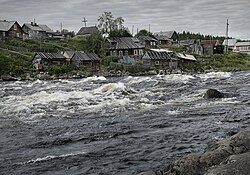
Tersky District is an administrative district (raion), one of the six in Murmansk Oblast, Russia. Municipally, it is incorporated as Tersky Municipal District. It is located in the south of the Kola Peninsula and borders the White Sea in the south. The area of the district is 19,300 square kilometers (7,500 sq mi). Its administrative center is the urban locality of Umba. District's population: 6,288 (2010 Census); 7,434 (2002 Census); 9,752 (1989 Census). The population of Umba accounts for 88.0% of the district's total population.

Murmansk Governorate was an administrative division of the early Russian SFSR which existed in 1921–1927. The governorate was established on the territory of former Alexandrovsky Uyezd of Arkhangelsk Governorate by the All-Russian Central Executive Committee (VTsIK) Decree issued on June 13, 1921. The administrative center was in Murmansk.

References

Coordinates: 66°40′N34°18′E / 66.667°N 34.300°E / 66.667; 34.300