
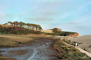
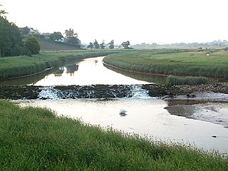
The River Axe is a 22-mile (35 km) long river in the counties of Dorset, Somerset and Devon, in the south-west of England. It rises in Dorset and flows south to Lyme Bay which it enters through the Axe Estuary in Devon. It is a shallow, non-navigable river, although its mouth at Seaton has some boating activity. The name Axe derives from a Common Brittonic word meaning "abounding in fish", and is cognate with pysg, the Welsh word for fish.

Mid Devon is a local government district in Devon, England. Its council is based in Tiverton.
The River Otter is a river that rises in the Blackdown Hills just inside the county of Somerset, England near Otterford, then flows south through East Devon. It enters the English Channel at the western end of Lyme Bay, part of the Jurassic Coast, a UNESCO World Heritage Site. The Permian and Triassic sandstone aquifer in the Otter Valley is one of Devon's largest groundwater sources, supplying drinking water to 200,000 people.

East Portlemouth is a small Devon village situated at the southern end of the Kingsbridge Estuary, on the south Devon Coast. The population of this parish taken at the 2011 census was 162. The village is sited on a hill giving views to the north to Kingsbridge and on a clear day as far as Dartmoor. There is a small ferry that runs to Salcombe in the opposite side of the estuary, and a beach that is popular with holidaymakers.
The River Okement is a tributary of the River Torridge in Devon, England. It used to be known as the River Ock.

The River Creedy is a small river in Devon, England. It gives its name to the local town or ton of Crediton, which is on its west bank, and to several local historic estates, namely Creedy Hilion, Creedy Peitevin and Creedy Park, in the parish of Sandford, also to the Benefice of North Creedy. Just below the town, the river merges with the River Yeo and it ends where it meets the River Exe at Cowley Bridge. The river is overlooked by Fordy Wood Copse, a 0.64 hectares woodland owned and managed by the Woodland Trust.

The River Lew can refer to either of two short rivers that lie close to each other in Devon, England.
The River Bovey rises on the eastern side of Dartmoor in Devon, England, and is the largest tributary to the River Teign. The river has two main source streams, both rising within a mile of each other, either side of the B3212 road between Moretonhampstead and Postbridge, before joining at Jurston.

The East Webburn is a stream in the Dartmoor moors in Devon in south-west England. It rises on the western side of the moors flowing off the west side of Hameldown ridge. Its source is less than 1 kilometre south west of Grimspound Bronze Age settlement. It flows south past Widecombe-in-the-Moor and joins the West Webburn River. These combined streams then join the River Dart close to the village of Holne.

The River Lemon is a 9.9 miles river in the county of Devon in southwest England. It is a tributary of the River Teign, starting on Dartmoor by Haytor, and ending in Newton Abbot. It rises on the south-east side of Dartmoor near Haytor, joins with the River Sig and the Langworthy Brook at Sigford, then passes the village of Bickington. Lower down, it is joined by the Kestor Brook and it then flows through the woods in Bradley Valley, past the manor house of Bradley, and through the town of Newton Abbot where it flows through a 440-yard-long tunnel below the town centre. Just below the town, the river joins the River Teign at 50.517°N 3.607°W, near the head of its estuary.

The West Webburn is a stream on Dartmoor in Devon in south-west England. It rises on the eastern side of the moors flowing off the east side of Hameldown Ridge. Its source is extremely close to the Grimspound Bronze Age settlement, and it was probably the main source of water for the settlement. It flows south, going past Widecombe-in-the-Moor, and joins the East Webburn River at Lizwell Meet in Oakmoor Wood. These combined streams then join the River Dart at Buckland Bridge in Holne Chase.
Exbourne is a village and civil parish in the English county of Devon. The Anglo-Saxon origin of the name is gæces burn - Cuckoo Stream. It occupies a hillside location between the River Okement and the Hole Brook, about 5 miles north of Okehampton in West Devon, and height above sea level ranges between 280 Ft. and 484 Ft. It lies in a primarily agricultural location and the local parish council represents both Exbourne and nearby Jacobstowe. The population of the ward which represents Exbourne and all surrounding villages was 1,695 at the 2011 census.
The River Clyst is a river of Devon, England. The name derives from Old English, and translates as Clean-stream. The river lends its name to several settlements on its route, Clyst Honiton, Clyst St Lawrence, Clyst St George, and Broadclyst. The William part of Clyst William derives from the Old English of aewelm, which means river source.

Combeinteignhead or Combe-in-Teignhead is a village in Teignbridge, South Devon, England. It lies within the civil parish of Haccombe with Combe, between Newton Abbot and Shaldon, about half a mile (1 km) inland from the estuary of the River Teign.

The River Sid, situated in East Devon, is often claimed to be the shortest complete river in England. It flows for 6.5 miles (10.5 km) southwards from a source in Crowpits Covert at a height of 206 metres above sea level. The source is at the head of a goyle or small ravine.

The O Brook is a short tributary of the West Dart River on Dartmoor in Devon, England. It lies near the village of Hexworthy, and the lower part of the stream forms the boundary between the parishes of Holne and Dartmoor Forest. An earlier form of the name was Ocbroke, and it may mean "Oak Brook", although oaks are rare in the area.

The River Ottery is a small river in northeast Cornwall, United Kingdom. The river is about twenty miles (32 km) long from its source southeast of Otterham to its confluence with the River Tamar at Nether Bridge, two miles (3.2 km) northeast of Launceston.

The St Austell River properly known as the River Vinnick, but historically called The White River, is a 12 kilometres (7.5 mi) long river located in south Cornwall, England, United Kingdom. 50.337°N 4.793°W. The river has also been known as the "red river" due to tin streaming and mining activity upstream.
Stoke Fleming is a village and civil parish in the South Hams district of Devon, England. It lies on the A379 road about one and a half miles south of the town of Dartmouth, at the north end of Start Bay and within the South Devon Area of Outstanding Natural Beauty. In 2001 the parish had a population of 1,012, compared to 708 in 1901, reducing again to 803 at the 2011 census The parish is a major part of the Skerries electoral ward. The ward's total population at the same census was 1,927. Stoke Fleming has a pub called The Green Dragon, a primary school, library and a football club.

Washbourne is a hamlet in the South Hams in Devon, England, 4 miles (6 km) south of Totnes. It consists of three settlements, Higher Washbourne, Middle Washbourne and Lower Washbourne. Higher and Middle Washbourne are in the civil parish of Halwell and Moreleigh. Lower Washbourne is divided between the civil parishes of Ashprington and Cornworthy.
