Related Research Articles
Bull Canyon Provincial Park is a provincial park in British Columbia, Canada, protecting Bull Canyon on the Chilcotin River, which is 7 km (4 mi) below the confluence of the Chilko River with the Chilcotin. The canyon and park are located just west of the community of Alexis Creek. Bull Canyon is part of a large volcanic plateau called the Chilcotin Group.
Blackcomb Glacier Provincial Park is a provincial park in British Columbia, Canada, located just east of and above the resort town of Whistler and adjacent to Garibaldi Provincial Park. The park was established in 1990 on land formerly protected by Garibaldi Park.
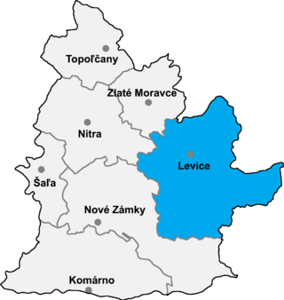
Kukučínov is a village and municipality in the Levice District in the Nitra Region of Slovakia.
Jibia,, is a town and Local Government Area (LGA) in Katsina State, northern Nigeria. The population of the LGA was approximately 125,000 as of 2003, and the area is 1037 km2.
Marlbank is a small community located in Tweed, Ontario, Canada, a few kilometers west of Highway 41.
Iqbal Nagar, is a town of the Punjab province of Pakistan. It is located at 32° 5' 30N 73° 47' 25E It is located in the Chichawatni Tehsil, which is an administrative subdivision of the District of Sahiwal. It is near Mian Channun city. There is a higher secondary school for both boys and girls separate, a post office and banks.
Kech is a town and union council in Dera Ismail Khan District of Khyber-Pakhtunkhwa. It is located at 32°5'30N 70°52'55E and has an altitude of 188 metres.
Lar is a town and union council in Dera Ismail Khan District of Khyber-Pakhtunkhwa. It is located at 32°5'30N 71°4'15E and has an altitude of 184 metres.
Meridiela is a small town and commune in the Cercle of Bougouni in the Sikasso Region of south-western Mali. In 1998 the commune had a population of 9,037.
Szary Kierz is a settlement in the administrative district of Gmina Czersk, within Chojnice County, Pomeranian Voivodeship, in northern Poland. It lies approximately 9 kilometres (6 mi) east of Czersk, 38 km (24 mi) east of Chojnice, and 71 km (44 mi) south-west of the regional capital Gdańsk.
Otalżyno is a village in the administrative district of Gmina Przodkowo, within Kartuzy County, Pomeranian Voivodeship, in northern Poland. It lies approximately 8 kilometres (5 mi) north-west of Przodkowo, 12 km (7 mi) north of Kartuzy, and 29 km (18 mi) west of the regional capital Gdańsk.
Pleśnik is a village in the administrative district of Gmina Bisztynek, within Bartoszyce County, Warmian-Masurian Voivodeship, in northern Poland. It lies approximately 12 kilometres (7 mi) east of Bisztynek, 25 km (16 mi) south-east of Bartoszyce, and 51 km (32 mi) north-east of the regional capital Olsztyn.
Góry is a settlement in the administrative district of Gmina Kętrzyn, within Kętrzyn County, Warmian-Masurian Voivodeship, in northern Poland. It lies approximately 4 kilometres (2 mi) east of Kętrzyn and 71 km (44 mi) north-east of the regional capital Olsztyn.
Wąsosz is a village in the administrative district of Gmina Złocieniec, within Drawsko County, West Pomeranian Voivodeship, in north-western Poland. It lies approximately 6 kilometres (4 mi) south-east of Złocieniec, 20 km (12 mi) east of Drawsko Pomorskie, and 101 km (63 mi) east of the regional capital Szczecin.
Đại Hóa is a commune (xã) and village in Tân Yên District, Bắc Giang Province, in northeastern Vietnam.

Samodiva Glacier is the 3.7 km long and 1.8 km wide glacier in the east part of Chavdar Peninsula in Graham Land on the Antarctic Peninsula. Situated east of Tumba Ice Cap and west of Pirin Glacier. Draining north-northeastwards east of Mount Pénaud to enter Curtiss Bay west of Seaplane Point.
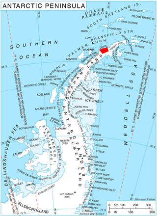
Pirin Glacier is the 5.7 km long and 6 km wide glacier situated next east of Chavdar Peninsula on Davis Coast on the Antarctic Peninsula. Situated west of Wright Ice Piedmont, north of Gregory Glacier and east of Samodiva Glacier. Draining north-northwestwards from Boulton Peak to enter Curtiss Bay east of Seaplane Point.
The Telen River is a river in East Kalimantan, Borneo island, Indonesia, about 110 kilometers north of the provincial capital Samarinda. It is a tributary of the Mahakam River.
Pitkasääremaa is a small islet in the Baltic Sea belonging to the country of Estonia.
References
- ↑ "Umuahala Google Map". Satellitecitymaps. Retrieved April 30, 2017.
5°26′00″N7°05′30″E / 5.43333°N 7.09167°E
| | This Abia state, Nigeria location article is a stub. You can help Wikipedia by expanding it. |