Related Research Articles

Anambra State is a Nigerian state, located in the southeastern region of the country. The state was created on 27 August 1991. Anambra state is bounded by Delta State to the west, Imo State and Rivers State to the south, Enugu State to the east and Kogi State to the north. The State's Capital is Awka, while the State’s Largest City is Onitsha which is regarded as one of the largest metropolis area in Africa. Nnewi is the second largest commercial and industrial city in Anambra State, and also a known automobile hub within Nigeria and Africa.

Aba is a city in southeastern Nigeria and the commercial centre of Abia State. Upon the creation of Abia State in 1991, the old Aba township was divided into two local government areas, being Aba South and Aba North, while the suburban neighborhood of what was then known as Obioma Ngwa L.G.A. was divided into three L.G.A.s for administrative convenience. Aba South is the main city centre of Aba and Abia State at large, being located on the Aba River. Aba is made up of many villages such as Aba-Ukwu, Eziukwu-Aba, Obuda-Aba, Umuokpoji-Aba and other villages that have been merged for administrative convenience. Aba was established by the Ngwa clan of the Igbo people in Nigeria as a market town. Later, a military post was placed there by the British colonial administration in 1901. It lies along the west bank of the Aba River and is at the intersection of roads leading to Port Harcourt, Owerri, Umuahia, Ikot Ekpene, and Ikot-Abasi. The city became a collection point for agricultural products following construction of a British-made railway running through it to Port Harcourt. Aba is a major urban settlement and commercial centre in its region, which is surrounded by small villages and towns. The indigenous people of Aba are the Ngwa. Aba is well known for its craftsmen and is the most populous city in southeastern Nigeria. As of 2016, Aba had an estimated population of 2,534,265, making it the biggest city in South Eastern Nigeria.

Ebonyi State is a state in the South-East geopolitical zone of Nigeria, bordered to the north and northeast by Benue State, Enugu State to the west, Cross River State to the east and southeast, and Abia State to the southwest. Named for the Abonyi (Aboine) River—a large part of which is in the state's south—Ebonyi State was formed from parts of Abia and Enugu state in 1996 and has its capital in Abakaliki.

Abakaliki is the capital city of Ebonyi State in southeastern Nigeria, located 64 kilometres (40 mi) southeast of Enugu. The inhabitants are primarily members of the Igbo nation. It was the headquarters of the Ogoja province before the creation of the Southeastern State in 1967.
Asaba is the capital of Delta State, Nigeria. A rapidly growing city, it is located at the western bank of the Niger River, in the Oshimili South Local Government Area. Asaba had a population of 149,603 as at the 2006 census, and a fast growing metropolitan population of over half a million people.

Enugu State is a state in the South-East geopolitical zone of Nigeria, bordered to the north by the states of Benue and Kogi, Ebonyi State to the east and southeast, Abia State to the south, and Anambra State to the west. The state takes its name from its capital and largest city, Enugu. The city acquired township status in 1917 and was called Enugwu-Ngwo. Due to the rapid expansion towards areas owned by other indigenous communities, it was renamed Enugu in 1928.

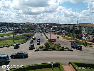
Awka is the capital city of Anambra State, Nigeria. The city was declared capital on 21 August 1991, after the creation of Anambra and Enugu state, which moved the capital from Enugu to Awka. The city has an estimated population of 301,657 as of the 2006 Nigerian census. The both LGAs of Awka South and North had a estimated population of 430,200 in 2022. The city is located at 199.1 kilometres (123.7 mi), by road, directly north of Port Harcourt in the centre of the densely-populated Igbo heartland in South-East Nigeria.
Aguata is a Local Government Area in Anambra State in Nigeria, with its headquarters in Aguata, a major part of which falls into Aguluezechukwu, while the smallest part falls within the commercial town of Ekwulobia. There has been an age-long contention on this issue between the locals of Aguluezechukwu and Ekwulobia, with both towns claiming the status of the headquarters on account of ownership claim to the 'Aguata land'. This state of affairs caused the Government of Anambra State to officially declare that the headquarters of Aguata Local Government Area should be Aguata in a bid to settle the conflict.

Malakal is a city in South Sudan, serving as the capital of Upper Nile State in the Greater Upper Nile region of South Sudan, along the White Nile River. It also serves as the headquarter of Malakal County and it used to be the headquarter of Upper Nile Region from the 1970s to the late 1990s.

Orlu is the second-largest city in South East, Imo State, Nigeria, with a population of 420,600. It has a long history as the headquarters for the Organisation of African Unity (OAU) and humanitarian relief agencies during the Nigeria-Biafra Civil War. The city houses the Nigerian headquarters of the British Cheshire Home. It is the second most developed city after Owerri in Imo state.

Igbo-Ukwu is a town in the Nigerian state of Anambra in the south-central part of the country. The town comprises three quarters namely Obiuno, Ngo, and Ihite with several villages within each quarter and thirty-six (36) administrative wards. It is also bordered by Ora-eri, Ichida, Azigbo, Ezinifite, Amichi, Isuofia, Ikenga and some other towns.
Awka'Awka South Local Government Area (LGA) is made up of nine towns, namely, Amawbia, Awka, Ezinato, Isiagu, Mbaukwu, Nibo, Nise, Okpuno and Umuawulu. There are three major streets that span this area, which are the Zik Avenue, Works Road and Arthur Eze Avenue. In the past, the people of Awka South LGA were well known for blacksmithing. Today they are respected among the Igbo people of Nigeria for their technical and business skills.
Ayamelum is a local government area (LGA) in Anambra state, in the southeastern part of Nigeria with headquarters in Anaku. The towns that make up the local government are Anaku, Umueje, Omasi, Igbakwu, Umumbo, Omor, Umuerum, and Ifite Ogwari. Ayamelum’s area is situated at the border between Enugu state and Anambra state. The communities in the area are notable for food production.
Onitsha South is a Local Government Area in Anambrs North Senatorial zone of Anambra State, Nigeria. The headquarters is in Fegge, Onitsha. Onitsha South is predominantly commercial with popular markets such as Ochanja market which attracts thousands of buyers and sellers of variety of commodities. The revenue of Onitsha South Local Government Area is generated mostly from commercial activities.
Achina is a town in Aguata local Government area of Anambra State, Nigeria. It is made up of three villages, Ebele; Umueleke and Umueziyi. Achina has common boundaries with Akpo, Umuchu, Onneh, Ogboji, and Enugwu-Umuonyia.
Ozubulu is a larger town in Anambra State, Nigeria. It is the headquarters of the Ekwusigo Local Government Area.
Ekwulobia is an Igbo-speaking town in southeastern Nigeria. It is one of the largest cities in Anambra State after Awka, Onitsha, and Nnewi and their respective conurbations. It is the headquarters of the present Aguata local government and the headquarters of the old Aguata Local Government that comprised the present Aguata local government and Orumba North and South local governments.
Ebenebe is a town in the Awka North Local Government Area of Anambra State, Nigeria. The town has an estimated population of 45,897 according to the 2006 Nigerian Census. Ebenebe is made up of eight villages, each of which contain hamlets.

Otulu is a town in Oru West local government area of Imo State, Nigeria. It is located along the Owerri-Onitsha Federal Highway in Imo State. Approaching from Owerri to Onitsha one will get to Awo-Omanma, Amiri and then Otulu after which one has Mgbidi; while from Onitsha to Owerri one has Otulu after Mgbidi.

Awo-Omamma, in the Northeast of Niger Delta basin is an oil-rich indigenous Igbo town on the banks of Njaba River. It is a potential tourism hub in the region due to its species of wildlife in Umuezukwe and green vegetation.
References
- 1 2 Google (25 September 2016). "Umuchu" (Map). Google Maps . Google. Retrieved 25 September 2016.
- ↑ Working Papers in Phonetics. University of California. 1974. p. 53.
- ↑ Jambula Tree: A Selection of Works from the Caine Prize for African Writing. New Internationalist Publications. 2008. p. 226. ISBN 978-1-904456-73-5.
- ↑ Sinha, R. K. (1989). The Paradise Lost: A Study of Modern English Novels Relating to Colonial Experience. Amar Prakashan. p. 138. ISBN 978-81-85061-80-1.
- ↑ "Umuchu weather and climate ☀️ Best time to visit 🌡️ Temperature". www.besttravelmonths.com. Retrieved 2023-08-12.