
A rock shelter is a shallow cave-like opening at the base of a bluff or cliff. In contrast to solutional caves (karst), which are often many miles long, rock shelters are almost always modest in size and extent.

Tourism in Albania has been a key element to the country's economic activity and is constantly developing. It is characterized by its rich archaeological and cultural heritage dating back to the classical period when Illyrians and Ancient Greeks inhabited the region. Over the course of history, the territory of Albania was occupied and populated by Romans, Byzantines, Venetians and Ottomans. Notably the country features unspoiled beaches, mountainous landscapes, traditional cuisine, archaeological artifacts, unique traditions, low prices and the wild atmosphere of the countryside.

Pachmarhi is a hill station in Narmadapuram district of Madhya Pradesh state of central India. It has been the location of a cantonment since British Raj.
Baripada is a city and a municipality in Mayurbhanj district in the state of Odisha, India. Located along the east bank of the Budhabalanga river, Baripada is the cultural centre of north Odisha. In recent years, it has emerged as an educational hub with the opening of numerous professional colleges.

Pirenópolis is a town located in the Brazilian state of Goiás. It is known for its waterfalls and Portuguese colonial architecture, and a popular festival involving mounted horses called Festa do Divino Espírito Santo which takes place 45 days after Easter.

Benue State is one of the North Central states in Nigeria with a population of about 4,253,641 in 2006 census. The state was created in 1976 among the 7 states created at that time.The state derives its name from the Benue River which is the second largest river in Nigeria. The state borders Nasarawa State to the North; Taraba State to the East; Kogi State to the West; Enugu State to the South-West; Ebonyi and Cross-Rivers States to the South; and has an international border with Cameroon to the South-East. It is inhabited predominantly by the Tiv, Idoma and Igede. Minority ethnic groups in Benue are Etulo, Igbo, Jukunpeoples etc. Its capital is Makurdi. Benue is a rich agricultural region; popularly grown crops include: oranges, mangoes, sweet potatoes, cassava, soya bean, guinea corn, flax, yams, sesame, rice, groundnuts, and Palm Tree.

Guatapé is a town and municipality in the Department of Antioquia, Colombia. It is a part of the subregion of Eastern Antioquia and is located 79 kilometres (49 mi) from Medellín, the capital of the department. Guatapé is bordered on the north by Alejandría, San Rafael to the east, and Granada and El Peñol to the south. This town is the gathering place for Las Vegas, referring to the small farms of the area.
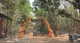
Kanger Ghati National Park was declared a national park in 1982 by the Government of India. Near Jagdalpur in the Bastar region of Chhattisgarh, it is one of India's densest national parks, and is known for its biodiversity, landscape, waterfalls, and subterranean geomorphologic limestone caves, and as the home of the Bastar hill myna, the state bird of Chhattisgarh.
Shahan Dasht, locally known as Shoon Dasht, is a village in Bala Larijan Rural District, Larijan District, Amol County, Mazandaran Province, Iran.
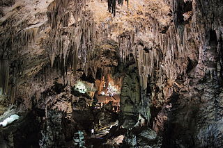
The Caves of Nerja are a series of caverns close to the town of Nerja in the Province of Málaga, Spain. Stretching for almost 5 kilometres (3.1 mi), the caverns are one of Spain's major tourist attractions. Concerts are regularly held in one of the chambers, which forms a natural amphitheatre.

Andhra Pradesh is a state in India. Andhra Pradesh Tourism Development Corporation (APTDC) is a state government agency which promotes tourism in Andhra Pradesh, describing the state as the Koh-i-Noor of India. Andhra Pradesh has a variety of tourist attractions including beaches, hills, caves, wildlife, forests and temples.
Umunze is the headquarters of Orumba south local government area in Anambra state of Nigeria. Its geographic coordinates are 5° 58′ 0″ north, 7° 13′ 0″ east.
Samasingha is a gram panchayat in the district of Jharsuguda in the state of Odisha in India. The block office and police station of Samasingha is Kolabira, site of the Kolabira fort. It is divided into fourteen wards. The MLA constituency is Jharsuguda and the MP constituency is Bargarh. The village is situated on the bank of the Bheden river, a tributary of the Mahanadi. Two small seasonal streams flow through the village, the larger is named Badbahal and the smaller Nalia. Bhugarapali, Junadihi, Belmunda, Jalapara/Jaladihi and Kumharmal are villages are in the neighbourhood of Samasingha. Other nearby places include Jharsuguda, Sambalpur, Kuchinda, Bamra and Bagdihi. The nearest place of tourist attraction is Gudguda. It is on the route between Sambalpur and Ranchi.

Yana is a tourist destination located in forests of Malenadu region of Uttara Kannada district of Karnataka state in India. Yana is one of the wettest villages in the world. It is the cleanest village in Karnataka, and the second cleanest village in India. The two unique rock outcrops near the village are a tourist attraction and easily approachable by a small trek through 0.5 kilometres (0.31 mi) of thick forests from the nearest road head.
Eluoma is a town in Amawu, Isuikwuato, Abia State of Nigeria. It is the largest town in Isuikwuato, having more than 10 distinct villages. It also occupies the largest geographical space in the whole of Isuikwuato, and has the most varied vegetation, relief and drainage. It shares boundaries with Amiyi Amaokwo, Amiyi Obilohia, Otampa, Umuasua, Umuobiala, Nnunya and Umuahia. It is a few kilometres from Abia State University, Uturu, Abia State and about 20 kilometres from Umuahia, the capital of Abia State, in the South Eastern part of Nigeria. Eluoma people are Igbos by ethnicity and belong to what was formally called Igbo Union from which the "Central Igbo" was derived.

Rajasthan is one of the most popular tourist destinations in India, for both domestic and international tourists. Rajasthan attracts tourists for its historical forts, palaces, art and culture with its slogan "Padharo mhare desh", now its changed. Every third foreign tourist visiting India travels to Rajasthan as it is part of the Golden Triangle for tourists visiting India.
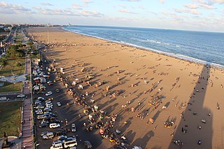
Tamil Nadu has the largest tourism industry in India with a percentage share of 21.31% and 21.86% of domestic and foreign tourist visits in the country. According to the 2020 Ministry of Tourism report, the number of domestic arrivals was at 494.8 million making the state the second most popular tourist destination in the country, and foreign arrivals numbered 6.86 million, the highest in the country, making it the most popular state for tourism in the country.
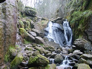
Burn O'Vat is a pothole located close to Loch Kinord near the village of Dinnet in Aberdeenshire, Scotland.
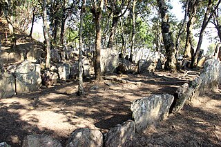
Mizoram is a state in the northeast of India. Mizoram is considered by many as a beautiful place due to its dramatic landscape and pleasant climate. There have been many attempts to increase revenue through tourism but many potential tourists find the lack of amenities to be a hurdle. However, the State continues to promote itself and many projects have been initiated. The tourism ministry continues to maintain or upgrade its tourist lodges throughout the state. Foreign tourists are required to obtain an 'inner line permit' under the special permit before visiting. The permit can be obtained from Indian missions abroad for a limited number of days or direct from Mizoram Government authorities within India. The state is rich in bird diversity, which has the potentiality to make it a major birding destination. For Mrs Hume's pheasant, Mizoram is a stronghold. There is also a rare record of the wild water buffalo from the state. There are several past records of the Sumatran rhinoceros from Mizoram, then Lushai Hills. The small population of wild elephants can be seen in Ngengpui and Dampa Sanctuaries. Some of the interesting sites are Mizo Poets' Square also known as Mizo Hlakungpui Mual in Mizo, the Great Megaliths locally known as 'Kawtchhuah Ropui'.
Ezira is an Igbo speaking town in south eastern Nigeria in the Orumba South local government area, Anambra state, Ezira is also known as Eziha which means "showing others the light" in the indigenous language. It has four satellite villages Obuotu, Ubaha, Imoohia and Okii, of which Obuotu is the head of the villages.


