Una-Una

Last updated

Una-Una (Indonesian: Pulau Una-Una) is an Indonesian island, part of the Togian Islands in the Gulf of Tomini. [1]

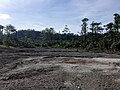
Una-Una is a small volcanic island created by the Colo volcano. Its vegetation primarily consists of coconut trees. Most of the island was devastated by pyroclastic flows following an eruption of the volcano in 1983. Currently its population is approximately 200 inhabitants and is concentrated in the island's 3 villages: Unauna, Kololio and Tampobatu. The island is part of the Central Sulawesi province.

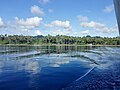
Una Una is surrounded by thriving reefs home to big schools of fish. It has been known as a location for scubadiving since the 1990s.

Related Research Articles

Flores Island of the Lesser Sunda Islands in Indonesia

Flores is one of the Lesser Sunda Islands, a group of islands in the eastern half of Indonesia. Including the Komodo Islands off its west coast, the land area is 15,530.58 km2, and the population was 1,878,875 in the 2020 Census ; the official estimate as at mid 2021 was 1,897,550. The largest towns are Maumere and Ende. The name Flores is the Portuguese word for "Flowers".

Krakatoa Volcanic caldera in the Sunda Strait

Krakatoa, also transcribed Krakatau, is a caldera in the Sunda Strait between the islands of Java and Sumatra in the Indonesian province of Lampung. The caldera is part of a volcanic island group comprising four islands. Two, Lang and Verlaten, are remnants of a previous volcanic edifice destroyed in eruptions long before the famous 1883 eruption; another, Rakata, is the remnant of a much larger island destroyed in the 1883 eruption.

<span class="mw-page-title-main">Coconut</span> Species of plant in the palm family

The coconut tree is a member of the palm tree family (Arecaceae) and the only living species of the genus Cocos. The term "coconut" can refer to the whole coconut palm, the seed, or the fruit, which botanically is a drupe, not a nut. The name comes from the old Portuguese word coco, meaning "head" or "skull", after the three indentations on the coconut shell that resemble facial features. They are ubiquitous in coastal tropical regions and are a cultural icon of the tropics.

<span class="mw-page-title-main">Java</span> Island in Indonesia, Southeast Asia

Java is one of the Greater Sunda Islands in Indonesia. It is bordered by the Indian Ocean to the south and the Java Sea to the north. With a population of 148.76 million people, Java is the world's most populous island, constituting approximately 55% of the Indonesian population.

Ring of Fire Region around the rim of the Pacific Ocean where many volcanic eruptions and earthquakes occur

The Ring of Fire is a region around much of the rim of the Pacific Ocean where many volcanic eruptions and earthquakes occur. The Ring of Fire is a horseshoe-shaped belt about 40,000 km (25,000 mi) long and up to about 500 km (310 mi) wide.

Ambon Island Island of Indonesia

Ambon Island is part of the Maluku Islands of Indonesia. The island has an area of 743.37 km2 (287.02 sq mi) and is mountainous, well watered, and fertile. Ambon Island consists of two territories: the city of Ambon to the south and various districts (kecamatan) of the Central Maluku Regency to the north. The main city and seaport is Ambon, which is also the capital of Maluku province, while those districts of Maluku Tengah Regency situated on Ambon Island had a 2020 Census population of 128,069. Ambon has an airport and is home to the Pattimura University and Open University, state universities, and a few private universities, which include Darussalam University and Universitas Kristen Indonesia Maluku (UKIM).

<span class="mw-page-title-main">Lake Maninjau</span> Body of water

Lake Maninjau is a caldera lake in West Sumatra, Indonesia. It is located 36 kilometres (22 mi) to the west of Bukittinggi, at 0°19′S100°12′E.

Palue Island in Indonesia

Palu'e Island is located north of Flores Island in the Flores Sea. It is part of Lesser Sunda Islands. Palu'e island is under the administrative region of Sikka regency of East Nusa Tenggara province, Indonesia.

Narcondam Island

Narcondam, India's easternmost island, is a small volcanic island located in the northern Andaman Sea. The island's peak rises to 710 m above mean sea level, and it is formed of andesite. It is part of the Andaman Islands, the main body of which lie approximately 74 km (46 mi) to the west.The island is part of the Indian union territory of Andaman and Nicobar Islands. The island is small, covering an area of approximately 6.8 square kilometres. It was classified as a dormant volcano by the Geological Survey of India.

<span class="mw-page-title-main">Alamagan</span>

Alamagan is an island in the Northern Mariana Islands in the Pacific Ocean, 30 nautical miles (56 km) north of Guguan, 250 nautical miles (463 km) north of Saipan, and 60 nautical miles (111 km) south of Pagan. It is currently uninhabited.

<span class="mw-page-title-main">Weh Island</span> Island in Aceh, Indonesia

Weh Island, often known as Sabang after the city of which the island is administrated, is a small active volcanic island to the northwest of Sumatra, 45 minutes by fast regular ship or 2 hours by ferry from mainland, Banda Aceh. It was originally connected to the Sumatran mainland and became separated by sea after the volcano's last eruption in the Pleistocene era. The island is situated in the Andaman Sea.

Mount Muria Dormant volcano on the northern coast of Java

Mount Muria or Gunung Muria is a dormant volcano on the north coast of Java, Indonesia. It is located in the center of the Muria peninsula, which juts northward into the Java Sea on the north coast of Central Java, Indonesia east of Semarang, the capital of the province. Mount Muria is 1602 meters high but once was maybe twice that height. Mount Muria was once an island, separated from Java by the Muria Strait. This strait closed around 1657.

Mount Colo Stratovolcano in Indonesia

Colo is a stratovolcano in Indonesia. It forms the small island of Una-Una at the middle of the Gulf of Tomini, the northern part of Sulawesi. The volcano is broad and has a low profile with only 507 metres (1,663 ft) above the sea level. It contains a 2 kilometres (1.2 mi) wide caldera with a small volcanic cone inside. Only three eruptions have been recorded in the history with two of them causing damage.

Blue-crowned lorikeet Species of bird

The blue-crowned lorikeet, also known as the blue-crowned lory, blue-crested lory, Solomon lory or Samoan lory, is a parrot found throughout the Lau Islands (Fiji), Tonga, Samoa, Niue and adjacent islands, including: ʻAlofi, Fotuhaʻa, Fulago, Futuna, Haʻafeva, Niuafoʻou, Moce, Niue, Ofu, Olosega, Samoa, Savaiʻi, Tafahi, Taʻu, Tofua, Tonga, Tungua, ʻUiha, ʻUpolu, Varoa, Vavaʻu, and Voleva. It is a 19 cm green lorikeet with a red throat, blue crown, and belly patch shading from red at the top to purple at the bottom.

Schouten Islands (Papua New Guinea)

The Schouten Islands are a group of six small volcanic islands in the province of East Sepik in Papua New Guinea, north of the island of New Guinea. The group is also called Eastern Schouten Islands or Le Maire Islands to separate it from unrelated Schouten Islands in Indonesia. The combined land area is approximately 50 km2 (19 sq mi).

São José da Coroa Grande is a city in Pernambuco with 21,586 inhabitants. It is southernmost city of the state on the coast section.

<span class="mw-page-title-main">Tojo Una-Una Regency</span> Regency in Central Sulawesi, Indonesia

Tojo Una-Una Regency is a regency of Central Sulawesi, Indonesia. The administrative centre is at Ampana town, on the Sulawesi 'mainland'. While the Regency includes a considerable area on the eastern peninsula of Sulawesi, it also includes the Togian Islands in the Gulf of Tomini. The total area covers 5,721.51 km2 and the population was 134,945 at the 2010 Census and 163,829 at the 2020 Census; the official estimate as at mid 2021 was 166,339.

Rondo Island is Indonesia's northernmost territory, located in the Andaman Sea, with a 0.650 km2 area 35m above sea level. The island is one of the outlying islands of Indonesia in the Aceh province of the Sumatra region. It is administratively part of Ujung Bau village in the Sukakarya District of Sabang City, whose administration center is on Weh Island, south of Rondo. Rondo is 50 km offshore from Indonesia's Sumatra mainland. This otherwise uninhabited island, accessible only by boat, has an Indonesian military outpost with a heliport and blue-roofed barracks, an adjacent lighthouse complex with a red-roofed lighthouse keeper's house and a white skeletal lighthouse topped with a viewing gallery and lantern.

<span class="mw-page-title-main">Colo-colo (condiment)</span> Indonesian hot and spicy condiment

Colo-colo is an acidic condiment commonly found in Maluku archipelago, Indonesia. It is believed to have originated in Ambon city, and accordingly is often described as Ambon's sambal. Colo-colo is similar to Manado's dabu-dabu, as they both use many chopped red chili peppers, bird's eye chili, shallots, red and green tomatoes, and a pinch of salt and sugar, mixed with fresh calamansi juice or locally known as lemon cui or jeruk kesturi.. The main difference is that colo-colo recipe often includes additional ingredients, such as chopped lemon basil, kenari nut, and tahi minyak or ampas minyak, or caramelized rarobang. As a result, colo-colo is darker and more oily than dabu-dabu.

References

  1. "Global Volcanism Program | Colo". volcano.si.edu. Retrieved 2015-09-27.

Coordinates: 0°10′12″S121°36′30″E / 0.1700°S 121.6083°E / -0.1700; 121.6083