
Grand Canyon National Park, located in northwestern Arizona, is the 15th site in the United States to have been named as a national park. The park's central feature is the Grand Canyon, a gorge of the Colorado River, which is often considered one of the Wonders of the World. The park, which covers 1,217,262 acres of unincorporated area in Coconino and Mohave counties, received more than 4.7 million recreational visitors in 2022, which is the second highest count of all American national parks after Great Smoky Mountains National Park. The Grand Canyon was designated a World Heritage Site by UNESCO in 1979. The park celebrated its 100th anniversary on February 26, 2019.

The Grand Canyon of the Yellowstone is the first large canyon on the Yellowstone River downstream from Yellowstone Falls in Yellowstone National Park in Wyoming. The canyon is approximately 24 miles (39 km) long, between 800 and 1,200 ft deep and from 0.25 to 0.75 mi wide.

Colorado National Monument is a National Park Service unit near the city of Grand Junction, Colorado. Sheer-walled canyons cut deep into sandstone and granite–gneiss–schist rock formations. This is an area of desert land high on the Colorado Plateau, with pinyon and juniper forests on the plateau. The park hosts a wide range of wildlife, including red-tailed hawks, golden eagles, ravens, jays, desert bighorn sheep, and coyotes. Activities include hiking, horseback riding, road bicycling, and scenic drives; a visitor center on the west side contains a natural history museum and gift shop. There are scenic views from trails, Rim Rock Drive, which winds along the plateau, and the campground. Nearby are the Book Cliffs and the largest flat-topped mountain in the world, the Grand Mesa.

Bandelier National Monument is a 33,677-acre (13,629 ha) United States National Monument near Los Alamos in Sandoval and Los Alamos counties, New Mexico. The monument preserves the homes and territory of the Ancestral Puebloans of a later era in the Southwest. Most of the pueblo structures date to two eras, dating between 1150 and 1600 AD.

Moro Rock is a granite dome rock formation in Sequoia National Park, California, United States. It is located in the center of the park, at the head of Moro Creek, between Giant Forest and Crescent Meadow. A stairway, designed by the National Park Service and built in 1931, is cut into and poured onto the rock, so that visitors can hike to the top. The view from the rock encompasses much of the Park, including the Great Western Divide. Use of this trail is discouraged during thunderstorms and when it is snowing.

Yellowstone Falls consist of two major waterfalls on the Yellowstone River, within Yellowstone National Park, Wyoming, United States. As the Yellowstone river flows north from Yellowstone Lake, it leaves the Hayden Valley and plunges first over Upper Falls of the Yellowstone River and then a quarter mile downstream over Lower Falls of the Yellowstone River, at which point it then enters the Grand Canyon of the Yellowstone, which is up to 1,000 feet deep.

Mount Washburn, elevation 10,219 feet (3,115 m), is a prominent mountain peak in the Washburn Range in Yellowstone National Park, Wyoming, United States. The peak was named in 1870 to honor Henry D. Washburn, leader of the Washburn–Langford–Doane Expedition. The Washburn Range is one of two mountains ranges completely within the boundaries of Yellowstone.

Wapama Falls is the larger of two waterfalls located on the northern wall of Hetch Hetchy Valley below Hetch Hetchy Dome, in Yosemite National Park. It flows almost year-round and during peak flow has been known to inundate the trail bridge crossing its base, making the falls impossible to pass. The falls consist of two primary drops angled roughly 60 degrees to each other, and a broad cascade at its base.

The Cook–Folsom–Peterson Expedition of 1869 was the first organized expedition to explore the region that became Yellowstone National Park. The privately financed expedition was carried out by David E. Folsom, Charles W. Cook and William Peterson of Diamond City, Montana, a gold camp in the Confederate Gulch area of the Big Belt Mountains east of Helena, Montana. The journals kept by Cook and Folsom, as well as their personal accounts to friends were of significant inspirational value to spur the organization of the Washburn-Langford-Doane Expedition which visited Yellowstone in 1870.
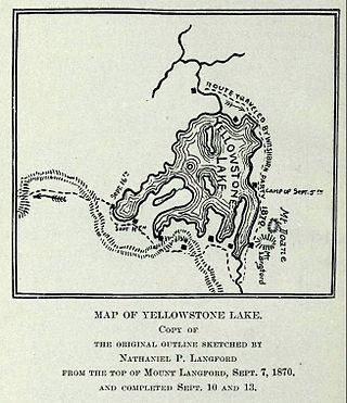
The Washburn Expedition of 1870 explored the region of northwestern Wyoming that two years later became Yellowstone National Park. Led by Henry D. Washburn and Nathaniel P. Langford, and with a U.S. Army escort headed by Lt. Gustavus C. Doane, the expedition followed the general course of the Cook–Folsom–Peterson Expedition made the previous year.

Darwin Falls is a waterfall located on the western edge of Death Valley National Park near the settlement of Panamint Springs, California. Although there exists a similarly named Darwin Falls Wilderness adjacent to the falls, the falls themselves are located in and administered by Death Valley National Park and the National Park Service. There are several falls, but they are mainly divided into the upper and lower, with a small grotto in between. At a combined 80 feet (24 m), it is the highest waterfall in the park. The canyon is walled by dramatic plutonic rock.

Eldorado Canyon State Park is part of the Colorado State Park system. It was established in 1978 and is located in Boulder County near the city of Boulder. The park consists of two areas, the Inner Canyon and Crescent Meadows. The park encompasses 885 acres (3.6 km2) with a variety of recreation opportunities available. Eldorado Canyon is home to one of the world's most accessible and comprehensive rock climbing areas. This state park is open during daylight hours only, visitors are expected to leave before dusk.

Angels Landing, known previously as the Temple of Aeolus, is a 1,488-foot (454 m) tall rock formation in Zion National Park in southwestern Utah, United States. A renowned trail cut into solid rock in 1926 leads to the top of Angels Landing and provides panoramic views of Zion Canyon.

The Grand Loop Road is a historic district which encompasses the primary road system in Yellowstone National Park. Much of the 140-mile (230 km) system was originally planned by Captain Hiram M. Chittenden of the US Army Corps of Engineers in the early days of the park, when it was under military administration. The Grand Loop Road provides access to the major features of the park, including the Upper, Midway and Lower geyser basins, Mammoth Hot Springs, Tower Fall, the Grand Canyon of the Yellowstone and Yellowstone Lake.

The Gardner River is a tributary of the Yellowstone River, approximately 25 miles (40 km) long, in northwestern Wyoming and south central Montana in the United States. The entire river is located within Yellowstone National Park. It rises on the slope of Joseph Peak, Gallatin Range in the northwestern part of the park, and winds southeast through Gardner's Hole, a broad subalpine basin which is a popular trout fishing location. The Gardner falls within the Native Trout Conservation Area and anglers are allowed to take an unlimited number of brown and rainbow trout. Mountain whitefish and Yellowstone cutthroat trout must be released. Angling on the Gardner is governed by Yellowstone National Park fishing regulations. After merging with Panther Creek, Indian Creek and Obsidian Creek, it then turns north and flows through a steep canyon where it cuts through a basaltic flow from approximately 500,000 years ago known as Sheepeater Cliffs. Below Sheepeater, Glen Creek out of Golden Gate Canyon and Lava Creek out of Lava Creek Canyon join the Gardner near Mammoth Hot Springs. The river crosses the 45th parallel in Gardner Canyon and is also home to a popular hot spring known as The Boiling River. The river continues north through Gardner Canyon and empties into the Yellowstone near Gardiner, Montana.

The following articles relate to the history, geography, geology, flora, fauna, structures and recreation in Yellowstone National Park.

Grebe Lake is a 156 acres (0.63 km2) backcountry lake in Yellowstone National Park most noted for its population of Arctic grayling. Grebe Lake comprises the headwaters of the Gibbon River. Grebe Lake is located approximately 3.1 miles (5.0 km) north of the Norris-Canyon section of the Grand Loop Road. The trail to the lake passes through mostly level Lodgepole Pine forest and open meadows. The lake was named by J.P. Iddings, a geologist with the Arnold Hague geologic surveys. There are four backcountry campsites located on the lake.

Trout Lake, formerly known as Fish Lake and Soda Butte Lake, is a 12 acres (0.049 km2) popular backcountry lake for hikers and anglers in Yellowstone National Park. The lake is located approximately .33 miles (0.53 km) north of the Northeast Entrance Road near the confluence of Pebble Creek and Soda Butte Creek. The lake sits in a depression on a high bench above the Soda Butte Creek Canyon. A steep trail through a Douglas fir forest leads to the lake. The trailhead is located at: 44°53′57″N110°7′21″W.

Golden Gate Canyon is in the northwestern region of Yellowstone National Park in the U.S. state of Wyoming. Glen Creek flows north through the canyon en route to the Gardner River descending from 7,400 feet (2,300 m) at Kingman Pass to just under 6,000 feet (1,800 m) in less than 3 miles (4.8 km). The northern portion of the Grand Loop Road traverses the canyon, connecting Mammoth Hot Springs with park features to the south.

The Chittenden Memorial Bridge is a 120 feet (37 m) concrete and steel arch bridge across the Yellowstone River just upstream from the Upper Yellowstone Falls in Yellowstone National Park. First constructed in 1903 as a Melan arch bridge by park engineer Captain Hiram M. Chittenden of the US Army Corps of Engineers, the bridge was known as Chittenden Bridge from 1912 until 1963, when it was replaced with the current structure. This bridge provides road access from the Grand Loop Road to the secondary road on the south rim of the Grand Canyon of the Yellowstone that allows visitors to see the upper and lower Yellowstone Falls from the south rim.
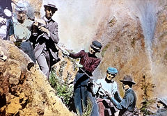 Visitors descending Uncle Tom's Trail
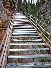 Uncle Tom's Trail, 2010

