Artist Point

Last updated
Artist Point [1]
Lookout Point
ViewFromArtistPointYNP.jpg
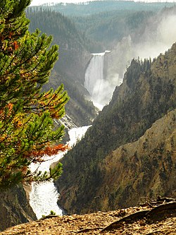
View from Artist Point
GrandCanyonoftheYellowstoneMap.JPG
Coordinates: 44°43′16″N110°28′46″W / 44.72111°N 110.47944°W / 44.72111; -110.47944
Location Yellowstone National Park, Park County, Wyoming, United States
Elevation2,329 m (7,641 ft)

Artist Point is an overlook point on the edge of a cliff [2] on the south rim of the Grand Canyon of the Yellowstone in Yellowstone National Park, Wyoming. The point is located east-northeast of Yellowstone Falls on the Yellowstone River. Artist Point was originally named in 1883 by Frank Jay Haynes who improperly believed that the point was the place at which painter Thomas Moran sketched his 1872 depictions of the falls. Later work determined that the sketches were made from the north rim, but the name Artist Point stuck. [3]

Notes

  1. "Artist Point". Geographic Names Information System . United States Geological Survey, United States Department of the Interior.
  2. Very steep or vertical slope (bluff, crag, head, headland, nose, palisades, precipice, promontory, rim, rimrock) "Feature Class Definitions". Geographic Names Information System. Retrieved 2012-08-18.
  3. Whittlesey, Lee H. (2006). Yellowstone Place Names. Gardiner, MT: Wonderland Publishing Company. p. 40. ISBN   1-59971-716-6.

Related Research Articles

<span class="mw-page-title-main">Yellowstone Falls</span> 2 waterfalls in Yellowstone National Park, Wyoming

Yellowstone Falls consist of two major waterfalls on the Yellowstone River, within Yellowstone National Park, Wyoming, United States. As the Yellowstone river flows north from Yellowstone Lake, it leaves the Hayden Valley and plunges first over Upper Falls of the Yellowstone River and then a quarter mile downstream over Lower Falls of the Yellowstone River, at which point it then enters the Grand Canyon of the Yellowstone, which is up to 1,000 feet deep.

<span class="mw-page-title-main">Union Falls</span> Waterfall in WY, US

Union Falls is a fan-type waterfall on Mountain Ash Creek, a tributary of the Fall River in the Cascade Corner (southwest) of Yellowstone National Park, in Wyoming, United States. With a height of 250 feet (76 m), it is the second tallest waterfall in Yellowstone, exceeded only by the lower Yellowstone Falls. The falls was named by members of the Arnold Hague Geological Surveys sometime between 1884 and 1886. Geologist J.P. Iddings claims the name derives from the fact that a tributary of Mountain Ash Creek joins at the very brink of the falls, thus Union Falls. Access to the falls is via the Mountain Ash Creek trail and the Grassy Lake Road.

<span class="mw-page-title-main">Lewis Falls</span> Waterfall in Yellowstone National Park, United States

The Lewis Falls are located on the Lewis River in Yellowstone National Park, Wyoming, United States. The falls drop approximately 30 feet (9.1 m) and are easily seen from the road, halfway between the south entrance to the park and Grant Village. The falls are on the Lewis River, just south of Lewis Lake.

<span class="mw-page-title-main">Mystic Falls</span> Waterfall in Teton County, Wyoming, United States

Mystic Falls is a 70-foot (21 m) cascade type waterfall on the Little Firehole River, a tributary of the Firehole River. Originally named Little Firehole Falls by members of the 1872 Hayden Geologic Survey, the name was changed to Mystic Falls by members of the Arnold Hague Geological Survey in 1885 for unknown reasons. Mystic Falls is reached via the 1.2 miles (1.9 km) Mystic Falls Trail which starts at Biscuit Basin in the Upper Geyser Basin.

<span class="mw-page-title-main">Bunsen Peak</span>

Bunsen Peak el. 8,564 feet (2,610 m) is a prominent peak due south of Mammoth Hot Springs in Yellowstone National Park, Wyoming. The peak lies on the east flank of Kingman Pass on the Mammoth to Norris section of the Grand Loop Road. The peak was first ascended by Ferdinand V. Hayden and Captain John W. Barlow in 1871, Bunsen Peak was not named until 1872 during the second Hayden Geologic Survey. E. S. Topping named the peak Observation Mountain in 1872 as well, but that name did not stick. The Bunsen Peak Trail with its trailhead just south of Mammoth is a steep 2.1 miles (3.4 km) to the summit. Bunsen Peak was named for the German chemist Robert Bunsen, the inventor of the Bunsen Burner and responsible for early work on volcanic geyser theories.

<span class="mw-page-title-main">First Peoples Mountain</span> Mountain in the state of Wyoming

First Peoples Mountain el. 10,551 feet (3,216 m) is a mountain peak in the Absaroka Range in Yellowstone National Park. The peak was formerly named for Lieutenant Gustavus Cheyney Doane, a U.S. Army cavalry officer who escorted the Washburn-Langford-Doane Expedition into Yellowstone in 1870. During that expedition, Doane and Nathaniel P. Langford ascended several peaks east of Yellowstone Lake. The name was changed to First Peoples Mountain in 2022.

<span class="mw-page-title-main">Colter Peak</span> Mountain in the state of Wyoming

Colter Peak el. 10,640 feet (3,240 m) is a mountain peak in the Absaroka Range in the southeastern section of Yellowstone National Park. The peak is named for mountain man John Colter, reputedly the first white man to visit the Yellowstone region. Colter Peak was first ascended in 1870 by Lt. Gustavus Cheyney Doane and Nathaniel P. Langford during the Washburn–Langford–Doane Expedition. Henry D. Washburn, the expedition leader named the peak for Langford and Doane. For unknown reasons, geologist Ferdinand V. Hayden moved those names to peaks farther north in 1871 during the Hayden Geological Survey of 1871. In 1888, Philetus Norris the second park superintendent, named the peak Mount Forum for unknown reasons. In 1885, geologist Arnold Hague gave the peak its official name: Colter Peak.

<span class="mw-page-title-main">Mount Langford</span> Mountain in Wyoming, United States

Mount Langford el. 10,623 feet (3,238 m) is a mountain peak in the Absaroka Range in Yellowstone National Park. The peak is named for Nathaniel P. Langford, the first superintendent of Yellowstone and a leader of the Washburn–Langford–Doane Expedition to Yellowstone in 1870. The expedition and Langford's subsequent promotion in Scribner's helped in the creation of the park in 1872.

<span class="mw-page-title-main">Bechler River</span> River

The Bechler River is a remote major river flowing southwest entirely within the confines of Yellowstone National Park to its confluence with the Fall River in the southwest section of the park. The river was named by Frank Bradley, a member of the 1872 Hayden Geological Survey for cartographer and explorer Gustavus R. Bechler, the chief surveyor and mapmaker on the survey. Henry Gannett also a member of the survey claimed that Bechler discovered the river, but trapper Osborne Russell explored the area in 1830.

<span class="mw-page-title-main">Fall River (Wyoming, Idaho)</span> River in Idaho, United States

Fall River rises on the Madison and Pitchstone Plateaus in the southwest corner of Yellowstone National Park, Wyoming and flows approximately 64 miles (103 km) to its confluence with the Henrys Fork of the Snake River near Ashton, Idaho. Historically, the river was referred to as the Middle Fork of the Snake River or as Fall River or the Falls River by trappers and prospectors as early as the 1830s. It was officially named the Falls River by the 1872 Hayden Geological Survey, but was always called Fall River by the locals and so the U.S. Board on Geographic Names changed the official name to Fall River in 1997 at the request of Idaho authorities. The river is home to numerous waterfalls and cascades in its upper reaches.

<span class="mw-page-title-main">Moose Falls</span> Waterfall in Teton County, Wyoming

Moose Falls is a plunge type waterfall on Crawfish Creek in Yellowstone National Park. The waterfall was named in 1885 by members of the Arnold Hague Geologic Survey for the plentiful moose found in the southern sections of the park. The falls are just 75 yards (69 m) west of south entrance road via an easy trail that begins 1.2 miles (1.9 km) north of the south entrance station.

<span class="mw-page-title-main">Bechler Falls</span> Waterfall in Teton County, Wyoming

Bechler Falls ht. 15 feet (4.6 m) is a waterfall on the Bechler River in Yellowstone National Park. Bechler Falls is the last waterfall on the Bechler River and is approximately 1 mile (1.6 km) from the confluence with the Fall River. It can be reached via the Bechler River trail approximately 3.5 miles (5.6 km) from the Cave Falls trailhead at the south boundary of the park. The falls were named in 1921 by explorers E. C. Gregg and C.H. Birdseye.

<span class="mw-page-title-main">Iris Falls</span> Waterfall in Teton County, Wyoming

Iris Falls is a waterfall on the Bechler River in Yellowstone National Park. Iris Falls is located just upstream from Colonnade Falls and is accessible via the Bechler River Trail. The falls were named in 1885 by members of the Arnold Hague Geological Survey for Iris, the mythological Greek goddess of the rainbow.

<span class="mw-page-title-main">Plateaus of Yellowstone National Park</span>

There are nine named plateaus in Yellowstone National Park. These plateaus are part of the much larger Yellowstone Plateau and dominate areas in the park south and west of the Gallatin and Absaroka mountain ranges. Four of the plateaus are from rhyolite lava flows that occurred between 110,000 and 70,000 years ago.

The following articles relate to the history, geography, geology, flora, fauna, structures and recreation in Grand Teton National Park.

<span class="mw-page-title-main">Inspiration Point (Yellowstone)</span>

Inspiration Point is a promontory cliff on the north rim of the Grand Canyon of the Yellowstone east of Yellowstone Falls on the Yellowstone River in Yellowstone National Park. The point was originally named Promontory Point in 1878 by W. H. Holmes but later given the name of Inspiration Point by G.L. Henderson, a park concessionaire in 1887. The point is a natural observation point over the rim of the Grand Canyon of the Yellowstone.

<span class="mw-page-title-main">Overhanging Cliff</span>

Overhanging Cliff is a cliff of vertical basalt that overhangs the Grand Loop Road just north of Tower Fall on the north rim of the Grand Canyon of the Yellowstone in Yellowstone National Park. The point was most likely named by a member of the Cook–Folsom–Peterson Expedition, David Folsum in 1869. It is the only place in the US in which the Contour lines cross

<span class="mw-page-title-main">Silver Cord Cascade</span> Waterfall in Wyoming, Yellowstone National Park

Silver Cord Cascade is a horsetail type waterfall on Surface Creek, a tributary of the Yellowstone River in Yellowstone National Park. Surface Creek flows out of Ribbon Lake off the South rim of the Grand Canyon of the Yellowstone and plunges 1,200 feet (370 m) to the Yellowstone River. It is considered the tallest waterfall in Yellowstone.

<span class="mw-page-title-main">Chittenden Memorial Bridge</span> Bridge

The Chittenden Memorial Bridge is a 120 feet (37 m) concrete and steel arch bridge across the Yellowstone River just upstream from the Upper Yellowstone Falls in Yellowstone National Park. First constructed in 1903 as a Melan arch bridge by park engineer Captain Hiram M. Chittenden of the US Army Corps of Engineers, the bridge was known as Chittenden Bridge from 1912 until 1963, when it was replaced with the current structure. This bridge provides road access from the Grand Loop Road to the secondary road on the south rim of the Grand Canyon of the Yellowstone that allows visitors to see the upper and lower Yellowstone Falls from the south rim.