
A suburb, more broadly suburban area, is an area within a metropolitan area, which may include commercial and mixed-use, that is primarily a residential area. A suburb can exist either as part of a larger city/urban area or as a separate political entity. The name describes an area which is not as densely populated as an inner city, yet more densely populated than a rural area in the countryside. In many metropolitan areas, suburbs exist as separate residential communities within commuting distance of a city Suburbs can have their own political or legal jurisdiction, especially in the United States, but this is not always the case, especially in the United Kingdom, where most suburbs are located within the administrative boundaries of cities. In most English-speaking countries, suburban areas are defined in contrast to central or inner city areas, but in Australian English and South African English, suburb has become largely synonymous with what is called a "neighborhood" in other countries, and the term encompasses inner city areas.

Zoning is a method of urban planning in which a municipality or other tier of government divides land into areas called zones, each of which has a set of regulations for new development that differs from other zones. Zones may be defined for a single use, they may combine several compatible activities by use, or in the case of form-based zoning, the differing regulations may govern the density, size and shape of allowed buildings whatever their use. The planning rules for each zone determine whether planning permission for a given development may be granted. Zoning may specify a variety of outright and conditional uses of land. It may indicate the size and dimensions of lots that land may be subdivided into, or the form and scale of buildings. These guidelines are set in order to guide urban growth and development.
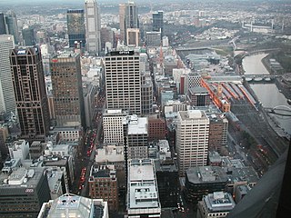
Hoddle Grid is the contemporary name given to the approximately 1-by-0.5-mile grid of streets that form the Melbourne central business district, Australia. Bounded by Flinders Street, Spring Street, La Trobe Street, and Spencer Street, it lies at an angle to the rest of the Melbourne suburban grid, and so is easily recognisable. It is named after the surveyor Robert Hoddle, who marked it out in 1837, establishing the first formal town plan. This grid of streets, laid out when there were only a few hundred settlers, became the nucleus for what is now Melbourne, a city of over five million people.

Lake Burley Griffin is an artificial lake in the centre of Canberra, the capital of Australia. It was completed in 1963 after the Molonglo River, which ran between the city centre and Parliamentary Triangle, was dammed. It is named after Walter Burley Griffin, the American architect who won the competition to design the city of Canberra.
Local government is the third level of government in Australia, administered with limited autonomy under the states and territories, and in turn beneath the federal government. Local government is not mentioned in the Constitution of Australia, and two referendums in 1974 and 1988 to alter the Constitution relating to local government were unsuccessful. Every state/territory government recognises local government in its own respective constitution. Unlike the two-tier local government system in Canada or the United States, there is only one tier of local government in each Australian state/territory, with no distinction between counties and cities.

Brisbane's recorded history dates from 1799, when Matthew Flinders explored Moreton Bay on an expedition from Port Jackson, although the region had long been occupied by the Yugara and Turrbal aboriginal tribes. The town was conceived initially as a penal colony for British convicts sent from Sydney. Its suitability for fishing, farming, timbering, and other occupations, however, caused it to be opened to free settlement in 1838. The town became a municipality in 1859 and a consolidated metropolitan area in 1924. Brisbane encountered major flooding disasters in 1893, 1974, 2011 and 2022. Significant numbers of US troops were stationed in Brisbane during World War II. The city hosted the 1982 Commonwealth Games, World Expo 88, and the 2014 G20 Brisbane summit.

The Mansions is a heritage-listed row of six terrace houses at 40 George Street, Brisbane City, City of Brisbane, Queensland, Australia. It was designed by G.H.M. Addison and built in 1889 by RE Burton. It was added to the Queensland Heritage Register on 21 August 1992.

Waterfront Place is an office building in the Brisbane central business district in Queensland, Australia. It is located at 1 Eagle Street, beside the Brisbane River. It was constructed by renowned Queensland builder and developer F. A. Pidgeon and Son who led the projects development in a joint venture with Folkestone Limited. Construction was completed in 1989. The building stands 162 metres (531 ft) tall.
The South East Queensland Regional Plan 2009-2031 is a statutory plan designed to guide regional growth and development in South East Queensland, Australia. It was established under the Integrated Planning Act 1997, which has now been replaced by The Sustainable Planning Act 2009.

Direct Factory Outlet (DFO) is a brand of factory outlet shopping centres in Australia. They are large-floor warehouse buildings containing partitioned stores where retail outlets sell excess or previous seasons' stocks at reduced prices. Vicinity Centres have full or partial ownership of seven of the eight stores.

Hawthorne is a suburb of the City of Brisbane, Queensland, Australia. In the 2016 census, Hawthorne had a population of 4,989 people.

Gumdale is an outer suburb of the City of Brisbane, Queensland, Australia. In the 2016 census, Gumdale had a population of 2,118 people.

Yeerongpilly is a southern suburb in the City of Brisbane, Queensland, Australia. In the 2016 census, Yeerongpilly had a population of 1,934 people.

Lands administrative divisions of Australia are the cadastral divisions of Australia for the purposes of identification of land to ensure security of land ownership. Most states term these divisions as counties, parishes, hundreds, and other terms. The eastern states of Queensland, New South Wales, Victoria, and Tasmania were divided into counties and parishes in the 19th century, although the Tasmanian counties were renamed land districts in the 20th century. Parts of South Australia (south-east) and Western Australia (south-west) were similarly divided into counties, and there were also five counties in a small part of the Northern Territory. However South Australia has subdivisions of hundreds instead of parishes, along with the Northern Territory, which was part of South Australia when the hundreds were proclaimed. There were also formerly hundreds in Tasmania. There have been at least 600 counties, 544 hundreds and at least 15,692 parishes in Australia, but there are none of these units for most of the sparsely inhabited central and western parts of the country.

Public housing in Australia is provided by departments of state governments. Australian public housing operates within the framework of the Commonwealth-State Housing Agreement, by which funding for public housing is provided by both federal and state governments. According to the 2006 census, Australia's public housing stock consisted of some 304,000 dwellings out of a total housing stock of more than 7.1 million dwellings, or 4.2% of all housing stock.
Urban planning in Australia has a significant role to play in ensuring the future sustainability of Australian cities. Australia is one of the most highly urbanised societies in the world. Continued population growth in Australian cities is placing increasing pressure on infrastructure, such as public transport and roadways, energy, air and water systems within the urban environment.

Toowoomba Wellcamp Airport is an airport in Wellcamp, 8.4 nautical miles west from the CBD of Toowoomba, Queensland, Australia. It was known as Brisbane West Wellcamp Airport until November 2017.
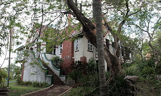
Kurrowah is a heritage-listed mansion at 218 Gladstone Road, Dutton Park, City of Brisbane, Queensland, Australia. It was designed by Lange Leopold Powell and built from 1915 to 1916. It was added to the Queensland Heritage Register on 13 June 2014.

McWhinneys Brick Cottage is a heritage-listed cottage at 47-55 Birley Street, Spring Hill, City of Brisbane, Queensland, Australia. It was built in the 1860s for Thomas McWhinney. It was added to the Queensland Heritage Register on 23 February 2001.

STH BNK by Beulah is a dual skyscraper development proposed for Melbourne developed by Beulah and designed by architectural firms UNStudio and Cox Architecture. The site currently hosts a BMW dealership.