Undulation of the geoid

Last updated

Undulation of the geoid is the height of the geoid relative to a given ellipsoid of reference. In maps and common use the height over the mean sea level (such as orthometric height) is used to indicate the height of elevations while the ellipsoidal height results from the GPS system.

Geoid irregular surface approximating the mean sea level

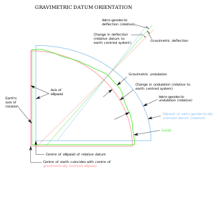
The geoid is the shape that the ocean surface would take under the influence of the gravity and rotation of Earth alone, if other influences such as winds and tides were absent. This surface is extended through the continents. According to Gauss, who first described it, it is the "mathematical figure of the Earth", a smooth but irregular surface whose shape results from the uneven distribution of mass within and on the surface of Earth. It can be known only through extensive gravitational measurements and calculations. Despite being an important concept for almost 200 years in the history of geodesy and geophysics, it has been defined to high precision only since advances in satellite geodesy in the late 20th century.

The orthometric height of a point is the distance H along a plumb line from the point to a reference height. When the reference height is a geoid model, orthometric height is for practical purposes "height above sea level".

The process of the undulation is not standardised, as different countries use different mean sea levels as reference but most commonly refers to the EGM96 geoid. Calculating the undulation factor is mathematically challenging. This is why many handheld GPS receivers have built-in undulation lookup tables [1] to determine the height above sea level.

EGM96 is a geopotential model of the Earth consisting of spherical harmonic coefficients complete to degree and order 360.

In computer science, a lookup table is an array that replaces runtime computation with a simpler array indexing operation. The savings in terms of processing time can be significant, since retrieving a value from memory is often faster than undergoing an "expensive" computation or input/output operation. The tables may be precalculated and stored in static program storage, calculated as part of a program's initialization phase (memoization), or even stored in hardware in application-specific platforms. Lookup tables are also used extensively to validate input values by matching against a list of valid items in an array and, in some programming languages, may include pointer functions to process the matching input. FPGAs also make extensive use of reconfigurable, hardware-implemented, lookup tables to provide programmable hardware functionality.

The deviation between the ellipsoidal height and the orthometric height can be calculated by

Likewise, the deviation between the ellipsoidal height and the normal height can be calculated by

Normal heights are heights above sea level, one of several types of height which are all computed slightly differently. Alternatives are: orthometric heights and dynamic heights.

Geoid undulations display uncertainties which can be estimated by using several methods, e.g. least-squares collocation (LSC), fuzzy logic, artificial neutral networks, radial basis functions (RBF), and geostatistical techniques. Geostatistical approach has been defined as the most improved technique in prediction of geoid undulation. [2]

Least squares method in statistics

The method of least squares is a standard approach in regression analysis to approximate the solution of overdetermined systems, i.e., sets of equations in which there are more equations than unknowns. "Least squares" means that the overall solution minimizes the sum of the squares of the residuals made in the results of every single equation.

Fuzzy logic is a form of many-valued logic in which the truth values of variables may be any real number between 0 and 1 inclusive. It is employed to handle the concept of partial truth, where the truth value may range between completely true and completely false. By contrast, in Boolean logic, the truth values of variables may only be the integer values 0 or 1.

Artificial neural network computational model used in machine learning, computer science and other research disciplines, which is based on a large collection of connected simple units called artificial neurons, loosely analogous to axons in a biological brain

Artificial neural networks (ANN) or connectionist systems are computing systems vaguely inspired by the biological neural networks that constitute animal brains. The neural network itself is not an algorithm, but rather a framework for many different machine learning algorithms to work together and process complex data inputs. Such systems "learn" to perform tasks by considering examples, generally without being programmed with any task-specific rules. For example, in image recognition, they might learn to identify images that contain cats by analyzing example images that have been manually labeled as "cat" or "no cat" and using the results to identify cats in other images. They do this without any prior knowledge about cats, for example, that they have fur, tails, whiskers and cat-like faces. Instead, they automatically generate identifying characteristics from the learning material that they process.

Related Research Articles

Geodesy The science of the geometric shape, orientation in space, and gravitational field of Earth

Geodesy, is the Earth science of accurately measuring and understanding Earth's geometric shape, orientation in space, and gravitational field. The field also incorporates studies of how these properties change over time and equivalent measurements for other planets. Geodynamical phenomena include crustal motion, tides, and polar motion, which can be studied by designing global and national control networks, applying space and terrestrial techniques, and relying on datums and coordinate systems.

Latitude The angle between zenith at a point and the plane of the equator

In geography, latitude is a geographic coordinate that specifies the north–south position of a point on the Earth's surface. Latitude is an angle which ranges from 0° at the Equator to 90° at the poles. Lines of constant latitude, or parallels, run east–west as circles parallel to the equator. Latitude is used together with longitude to specify the precise location of features on the surface of the Earth. On its own, the term latitude should be taken to be the geodetic latitude as defined below. Briefly, geodetic latitude at a point is the angle formed by the vector perpendicular to the ellipsoidal surface from that point, and the equatorial plane. Also defined are six auxiliary latitudes which are used in special applications.

Sea level Average level for the surface of the ocean at any given geographical position on the planetary surface

Mean sea level (MSL) is an average level of the surface of one or more of Earth's oceans from which heights such as elevation may be measured. MSL is a type of vertical datum – a standardised geodetic datum – that is used, for example, as a chart datum in cartography and marine navigation, or, in aviation, as the standard sea level at which atmospheric pressure is measured to calibrate altitude and, consequently, aircraft flight levels. A common and relatively straightforward mean sea-level standard is the midpoint between a mean low and mean high tide at a particular location.

Earth radius mean distance from the Earths center to its surface

Earth radius is the distance from a selected center of Earth to a point on its surface, which is often chosen to be sea level, or more commonly, the surface of an idealized ellipsoid representing the shape of Earth. Because Earth is not a perfect sphere, the determination of Earth's radius can have several values, depending on how it is measured; from its equatorial radius of about 6,378 kilometres to its polar radius of about 6,357 kilometres.

Physical geodesy The study of the physical properties of the Earths gravity field

Physical geodesy is the study of the physical properties of the gravity field of the Earth, the geopotential, with a view to their application in geodesy.

Geopotential is the potential of the Earth's gravity field. For convenience it is often defined as the negative of the potential energy per unit mass, so that the gravity vector is obtained as the gradient of this potential, without the negation.

World Geodetic System geodetic reference system

The World Geodetic System (WGS) is a standard for use in cartography, geodesy, and satellite navigation including GPS. This standard includes the definition of the coordinate systems fundamental and derived constants, the ellipsoidal (normal) Earth Gravitational Model (EGM), a description of the associated World Magnetic Model (WMM), and a current list of local datum transformations.

Figure of the Earth mathematical descriptions of Earths complex shape

The figure of the Earth is the size and shape of the Earth in geodesy. Its specific meaning depends on the way it is used and the precision with which the Earth's size and shape is to be defined. While the sphere is a close approximation of the true figure of the Earth and satisfactory for many purposes, geodesists have developed several models that more closely approximate the shape of the Earth so that coordinate systems can serve the precise needs of navigation, surveying, cadastre, land use, and various other concerns.

Vertical deflection

The vertical deflection at a point on the Earth is a measure of how far the gravity direction has been shifted by local anomalies such as nearby mountains. They are widely used in geodesy, for surveying networks and for geophysical purposes.

Geodetic datum reference frame used in geodesy, surveying, chartography and navigation

A geodetic datum or geodetic system is a coordinate system, and a set of reference points, used to locate places on the Earth. An approximate definition of sea level is the datum WGS 84, an ellipsoid, whereas a more accurate definition is Earth Gravitational Model 2008 (EGM2008), using at least 2,159 spherical harmonics. Other datums are defined for other areas or at other times; ED50 was defined in 1950 over Europe and differs from WGS 84 by a few hundred meters depending on where in Europe you look. Mars has no oceans and so no sea level, but at least two martian datums have been used to locate places there.

Benchmark (surveying) point with known height used in surveying when levelling

The term benchmark, or bench mark, originates from the chiseled horizontal marks that surveyors made in stone structures, into which an angle-iron could be placed to form a "bench" for a leveling rod, thus ensuring that a leveling rod could be accurately repositioned in the same place in the future. These marks were usually indicated with a chiseled arrow below the horizontal line.

Mikhail Sergeevich Molodenskii was a famous Soviet physical geodesist. He was once said to be "probably the only geodesist who would have deserved a Nobel prize"

Sea Level Datum of 1929 vertical datum in the United States

The Sea Level Datum of 1929 was the vertical datum established for vertical control surveying in the United States of America by the General Adjustment of 1929. The datum was used to measure elevation (altitude) above, and depression (depth) below, mean sea level (MSL).

North American Vertical Datum of 1988

The North American Vertical Datum of 1988 is the vertical datum for orthometric heights established for vertical control surveying in the United States of America based upon the General Adjustment of the North American Datum of 1988.

Earth ellipsoid ellipsoid of rotation that approximates the figure of the Earth

An Earth ellipsoid is a mathematical figure approximating the Earth's form, used as a reference frame for computations in geodesy, astronomy, and the geosciences. Various different ellipsoids have been used as approximations.

Vertical datum

A vertical datum or height datum is a reference surface for vertical positions, such as the elevations of Earth features including terrain, bathymetry, water level, and man-made structures. Vertical datums are either: tidal, based on sea levels; gravimetric, based on a geoid; or geodetic, based on the same ellipsoid models of the Earth used for computing horizontal datums.

<i>Normalhöhennull</i> standard reference level, the equivalent of sea level, used in Germany to measure height

Normalhöhennull or NHN is a vertical datum used in Germany.

References

  1. Wormley, Sam. "GPS Orthometric Height". www.edu-observatory.org. Archived from the original on 20 June 2016. Retrieved 15 June 2016.
  2. Chicaiza, E.G.; Leiva, C.A.; Arranz, J.J.; Buenańo, X.E. (2017-06-14). "Spatial uncertainty of a geoid undulation model in Guayaquil, Ecuador". Open Geosciences. 9 (1): 255–265. Bibcode:2017OGeo....9...21C. doi:10.1515/geo-2017-0021. ISSN   2391-5447.