
The Harz is a highland area in northern Germany. It has the highest elevations for that region, and its rugged terrain extends across parts of Lower Saxony, Saxony-Anhalt, and Thuringia. The name Harz derives from the Middle High German word Hardt or Hart, Latinized as Hercynia. The Brocken is the highest summit in the Harz with an elevation of 1,141.1 metres (3,744 ft) above sea level. The Wurmberg is the highest peak located entirely within the state of Lower Saxony.

Clausthal-Zellerfeld is a town in Lower Saxony, Germany. It is located in the southwestern part of the Harz mountains. Its population is approximately 15,000. The City is the location of the Clausthal University of Technology. The health resort is located in the Upper Harz at an altitude between 390 and 821 m above sea level.

Altenau is a town and a former municipality in the district of Goslar, in Lower Saxony, Germany. Since 1 January 2015 it is part of the town Clausthal-Zellerfeld.
The Langelsheim–Altenau (Oberharz) railway was a railway line, that ran through the Upper Harz in Central Germany. It was also called the Upper Harz Railway or Harz Railway. It was built in order to enable the Magdeburg-Halberstadt Railway Company to access the mines in the Harz mountains.

The Dennert Fir Tree is a signboard that is used throughout the Harz mountains in Germany to provide information about mining and other points of interest in the area. The signboards mark locations, traces and monuments to mining, to the Upper Harz Water Regale, a medieval water management system, or even personalities in mining history in the Upper Harz mining area. They have since become used to document other notable sites within the Harz.

The Upper Harz refers to the northwestern and higher part of the Harz mountain range in Germany. The exact boundaries of this geographical region may be defined differently depending on the context. In its traditional sense, the term Upper Harz covers the area of the seven historical mining towns (Bergstädte) - Clausthal, Zellerfeld, Andreasberg, Altenau, Lautenthal, Wildemann and Grund - in the present-day German federal state of Lower Saxony. Orographically, it comprises the Harz catchment areas of the Söse, Innerste and Grane, Oker and Abzucht mountain streams, all part of the larger Weser watershed.

The Upper Harz Ditches are hillside ditches, running roughly parallel to the contour lines, that were laid out in the Upper Harz in Germany from the 16th to the 19th centuries to supply water power to the silver mines there. They are an important component of the Upper Harz Water Regale, a historical water system that is now a cultural monument.
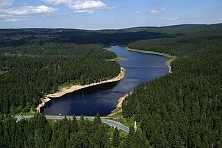
The Oderteich is an historic reservoir about seven kilometres northeast of Sankt Andreasberg in the Upper Harz in central Germany. It was built by miners from St. Andreasberg in the years 1715 to 1722 and, today, is an important component of the water supply network known as the Upper Harz Water Regale. Moreover, for 170 years, from the time it was completed to the end of the 19th century, the Oderteich had the largest dam in Germany. The dam lies at a height of 725 m above NN by the B 242 federal highway, about a kilometre west of its intersection with the B 4.
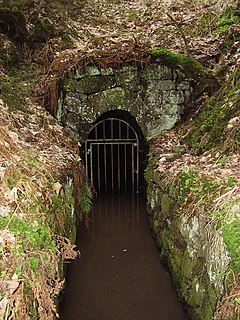
The Upper Harz Water Tunnels are part of the Upper Harz Water Regale - a network of reservoirs, ditches, tunnels and other structures in the Harz mountains of central Germany. The German term Wasserlauf refers to the underground element of the network of watercourses used in the historic silver mining industry of the Upper Harz. This network of ditches and tunnels was used to supply the mines with headrace waters for their water wheels from the 16th century onwards. In the system of the Upper Harz Water Regale there are over 35 such tunnels with a total length of about 30 km.

The Upper Harz Ponds are found mainly around the mining town of Clausthal-Zellerfeld and the nearby villages of Buntenbock and Hahnenklee in the Upper Harz mountains of central Germany. There are around 70 ponds in total, both large and small. They were built by the miners of the Upper Harz, mostly between the 16th and 18th centuries, and are important components of the cultural monument known as the Upper Harz Water Regale - a network of dams, ditches, ponds and tunnels that was built to supply much-needed water power for the mining industry in the Harz mountains. Today the Water Regale is being proposed as a UNESCO World Heritage Site. About half the dammed ponds are classified today as reservoirs, but they have now become characteristic features of the Upper Harz and are home to some extremely rare plant and animal species.

The Polsterberg Pumphouse is a pumping station above the Dyke Ditch in the Upper Harz in central Germany which is used today as a forest restaurant.
The Upper Harz Water Regale is a system of dams, reservoirs, ditches and other structures, much of which was built from the 16th to 19th centuries to divert and store the water that drove the water wheels of the mines in the Upper Harz region of Germany. The term regale, here, refers to the granting of royal privileges or rights in this case to permit the use of water for mining operations in the Harz mountains of Germany.

Mining in the Upper Harz region of central Germany was a major industry for several centuries, especially for the production of silver, lead, copper, and, latterly, zinc as well. Great wealth was accumulated from the mining of silver from the 16th to the 19th centuries, as well as from important technical inventions. The centre of the mining industry was the group of seven Upper Harz mining towns of Clausthal, Zellerfeld, Sankt Andreasberg, Wildemann, Grund, Lautenthal und Altenau.

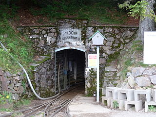
The Samson Pit or Samson Mine is an historic silver mine in Sankt Andreasberg in the Upper Harz region of central Germany.

A Kunstteich is an historic German term for a man-made lake or pond associated with the mining industry and its technology. These ponds were created by the construction of barriers, typically dams and embankments, and were used to supply hydropower and water to the mines. Water stored in the reservoir was used for a variety of purposes. It was used to turn water wheels that in turn drove the various mechanical devices used in mining in earlier centuries, such as man engines. It was also used to produce power and drain the mines, or in the processing of ore. In principle, all Kunstteiche are small dam and reservoir installations. The oldest working dams in Germany are Kunstteiche.

The Glasebach Pit is a mining museum and former pit in the Harz fluorspar mining area near Straßberg in the German state of Saxony-Anhalt. It is run by the East Harz Mining Society. The pit was founded under the name of Vertrau auf Gott.

The Huttaler Widerwaage is a small reservoir that is a part of the Upper Harz Water Regale, an old mining water management system in the Harz Mountains of Germany that is now a UNESCO World Heritage Site. The reservoir lies east of the mining town of Clausthal-Zellerfeld. It is designed to feed water from the Huttal river during times of low water to the reservoir pond of the Hirschler Teich and, during times of high water, to handle the overflow of water from it.
The Emperor William Shaft was the central hoisting and man-riding shaft of the lead and zinc mine in Clausthal-Zellerfeld in the Upper Harz in central Germany.

The Maaßener Gaipel is a pub catering for day trippers on the northeastern hillside of the Kranichsberg at a height of 420 m above NN, situated above the mining town of Lautenthal in the Harz Mountains of central Germany. The name goes back to the above-ground workings of the Maaßener Treibschacht or Maaßen Hoisting Shaft 51°51′49″N10°17′25″E, which was located immediately east of the inn. Gaipel is a common expression in the Upper Harz for a headframe and goes back to the use of a horse whim which in German is a Pferdegöpel. Whims were used to transport men and materiel up and down mineshafts, for example using man engines, and also to operate water management equipment. Maaßen is shorthand for the name of the local pit which was the Grube Zweite, Dritte, Vierte, Fünfte und Sechste Maß nach der Sachsenzeche. Maaß, also variously spelt Maaß, Maas or Mas, is a unit of length for a pit field (Grubenfeld) and in mining in the Upper Harz measured 28 Lachter or 53.8 metres. The pub was built in 1924 on the initiative of the Harz Club on the terrain of the old mine shaft. But decades before the area had already become a popular destination with walkers due to its views of the mining town and the valley of the Laute.
The Schauinsland Pit was a silver and lead mine east of Freiburg im Breisgau. From the 19th century zinc was also mined. The mine operated from the 13th century until 1954. Since 1997 Schauinsland Pit has been a show mine.


