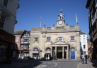
Montgomery is a town and community in the Welsh Marches, administratively in the Welsh county of Powys. It is the traditional county town of the historic county of Montgomeryshire to which it gives its name. The town centre lies about 1 mile (1.6 km) west of the English border. Montgomery Castle was started in 1223 and its parish church in 1227. Other locations in the town include The Old Bell Museum, the Offa's Dyke Path, the Robber's Grave and the town wall. The large Iron Age hill fort of Ffridd Faldwyn is sited northwest of the town and west of the Castle.

Berriew is a village, community and electoral ward in Montgomeryshire, Powys, Wales, on the Montgomeryshire Canal and the Afon Rhiw near the confluence with the River Severn at grid reference SJ185005, 79 miles (128 km) from Cardiff and 151 miles (243 km) from London. The village itself had a population of 283. and the community also includes Garthmyl Hall and Refail.

Pontrobert is an ecclesiastical parish that was formed in September 1854. It comprises the townships of Teirtref and part of Nantymeichiaid in the parish Meifod, a portion of Cynhinfa which was in the parish of Llangynyw and portions of the townships of Fachwel, Llaethbwlch and Cadwnfa which were in the parish of Llanfihangel. The total area of this parish is 5,000 acres. As a result of this arrangement, Pont Robert is now divided between the present day Community Councils of Meifod, Llangyniew and Mawddwy. Pontrobert was within the historic county of Montgomeryshire, now forming part of Powys. The name Pontrobert is derived from Robert ap Oliver of Cyhinfa, who built the original bridge over the River Vyrnwy around 1700. An alternative Welsh name for Pontrobert is Pont y ddolfeiniog.
Kerry is a village and geographically large community in Montgomeryshire, Powys, Wales.

Thomas Penson, or Thomas Penson the younger was the county surveyor of Denbighshire and Montgomeryshire. An innovative architect and designer of a number of masonry arch bridges over the River Severn and elsewhere. He was the son of Thomas Penson the older,, who had been the county surveyor for Flintshire from 1810 to 1814, but had been dismissed when the bridge at Overton-on-Dee collapsed. Thomas Penson the younger, completed its replacement. Thomas Penson the younger had two sons: Thomas Mainwaring Penson and Richard Kyrke Penson, both of whom were architects and both practised in Chester

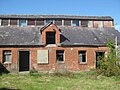
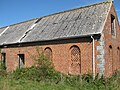
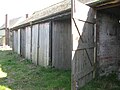
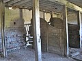
Leighton Hall is an estate located to the east of Welshpool in the historic county of Montgomeryshire, now Powys, in Wales. Leighton Hall is a listed grade I property. It is located on the opposite side of the valley of the river Severn to Powis Castle. The Leighton Hall Estate is particularly notable for the Hall which was decorated and furnished by the Craces to designs by Pugin in his Houses of Parliament style, and for the Home Farm, a model farm, which was to be in the forefront of the Victorian industrialised High Farming. Leighton Hall was also the birthplace of the much disparaged hybrid Cupressocyparis leylandii hedge tree. The Hall is now in private ownership and is not accessible to the public, although it can still be viewed from the road. The Home Farm is currently under restoration.

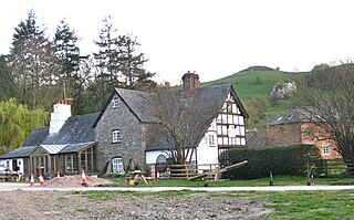
Maesmawr Hall is a historic timber-framed house, situated to the southeast of Caersws, in the historic county of Montgomeryshire, which now forms part of Powys in Wales. It is currently run as a hotel. A long avenue approaches the front of the property from the south.

Forden is a village near Welshpool in Powys, Wales, formerly in the historic county of Montgomeryshire. It forms part of the community of Forden, Leighton and Trelystan with the neighbouring settlements of Trelystan, Leighton and Kingswood.

A demonstration farm, or model farm, is a farm which is used primarily to research or demonstrate various agricultural techniques, with any economic gains being an added bonus. Demonstration farms are often owned and operated by educational institution or government ministries. It is also common to rent land from a local farmer. The leaser is allowed to perform their demonstrations, while the land owner can be paid for the land usage or may be given the resulting crops.
Llandyssil is a village in Powys, Wales, about two miles from the town of Montgomery.
Nantcribba is a township in the parish of Forden in the historic county of Montgomeryshire and now in Powys It is also the site of Nantcribba Castle which was built by the Corbett, Barons of Caus, of Caus Castle in Shropshire. To the south of the Castle site was Nantcribba Hall, which was owned by the Devereux family and the Marquises of Hereford. In the 19th century Nantcribba became part of the Leighton Hall estates.
Poundley and Walker or John Wilkes Poundley and David Walker were a land surveyors and architects’ partnership with offices at Black Hall, Kerry, Montgomeryshire and at Unity Buildings, 22 Lord Street, Liverpool. The partnership was established probably in the mid-1850s and was dissolved in June 1867. The partnership was involved with large country estate building projects, church and civic buildings and some civil engineering. They specialized in building model farms. J. W. Poundley was also the county surveyor for Montgomeryshire from 1861–1872. The architect, canal and railway engineer, T. G. Newnham appears have been associated with the partnership.
William Baker of Audlem (1705–1771) was an architect, surveyor and building contractor, working in Shropshire and the adjacent counties in the middle years of the 18th century.
Cilthriew is a Grade II listed house and former farm in Kerry, Powys, in the historic county of Montgomeryshire, now Powys. Cilthriew was used by the Papworth Trust which provided a range of high quality services for disabled and disadvantaged people. Cilthriew provided free short breaks for disabled people and their families in a farm surrounding.

Garthmyl Hall is a Grade II listed house in Berriew, in the historic county of Montgomeryshire, now Powys. The house stood close to the site of a large 17th-century large timber-framed house. Garthmyl Hall was rebuilt in 1859 by the architect James K Colling for Major-General William George Gold.

James Kellaway Colling (1816–1905) or J. K. Colling was an English architect, watercolour artist and noted book illustrator. He was a pioneer of early Chromolithographic printing and his graphic work has been compared with that of William Morris and John Ruskin
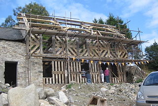
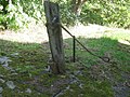
Glas Hirfryn is a farm in Cwmdu, at east side of the road through the valley of the Lleiriog on the southern side of the Berwyn Mountains. It is in the community of Llansilin, which was formerly in Denbighshire, but since 1996 has been in the Montgomeryshire part of Powys. The timber-framed farmhouse, which stands within a group of farm buildings was abandoned in the mid-20th century, at which time it was listed as Grade II. The house has now been dated by dendrochronology to about 1559 AD or shortly afterwards.
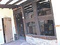
Trewern Hall or Trewern Farmhouse is a country house in Montgomeryshire, Wales, close to the Shropshire border. It is on a spur in the floodplain of the river Severn, in the Trewern community area of what is now Powys, to the north of the A458 road from Shrewsbury to Welshpool. It is a fine example of a Severn Valley Half-timbered house. The Grade II* listed hall was occupied by the Lloyd, Francis and Whittaker families. In 1985-6 and 1993-4 it was extensively restored with some remodelling by the architect M.J.Garner for Murray.Ll. Chapman.

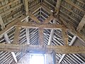
Plasau Duon or Plasauduon is a timber-framed house, formerly in the parish of Carno, but now within the area of the community council of Caersws in the historic county of Montgomeryshire, and now in Powys, Wales. It is located on a site above the left bank of the Afon Carno, on a farm road leading off the lane from the A.470 to Bwlch-y-garreg. It is a fine example of a ‘’Severn Valley’’ house and has a Grade II* listing. It is likely to have been built in the second half of the 16th. century.

Architecture of Wales is an overview of architecture in Wales from the Medieval period to the present day, excluding castles and fortifications, ecclesiastical architecture and industrial architecture. It covers the history of domestic, commercial, and administrative architecture.