
Sawtooth National Forest is a National Forest that covers 2,110,408 acres in the U.S. states of Idaho and Utah. Managed by the U.S. Forest Service in the U.S. Department of Agriculture, it was originally named the Sawtooth Forest Reserve in a proclamation issued by President Theodore Roosevelt on May 29, 1905. On August 22, 1972 a portion of the forest was designated as the Sawtooth National Recreation Area (SNRA), which includes the Sawtooth, Cecil D. Andrus–White Clouds, and Hemingway–Boulders wilderness areas. The forest is managed as four units: the SNRA and the Fairfield, Ketchum, and Minidoka Ranger Districts.

The Sawtooth National Recreation Area (SNRA) is a national recreation area in central Idaho, United States that is managed as part of Sawtooth National Forest. The recreation area, established on August 22, 1972, is managed by the U.S. Forest Service, and includes the Sawtooth, Hemingway–Boulders, and Cecil D. Andrus–White Clouds wilderness areas. Activities within the 730,864-acre (2,957.70 km2) recreation area include hiking, backpacking, White water rafting, camping, rock climbing, kayaking, mountain biking, fishing, and hunting.

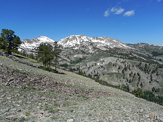
The Soldier Mountains are a mountain range in the U.S. state of Idaho, spanning northern Camas and eastern Elmore counties. The highest point in the range is Smoky Dome at 10,095 feet (3,077 m), and the range is bounded on the west and north by the South Fork Boise River. The mountains are located within Sawtooth National Forest north of Fairfield, Idaho. The Soldier Mountain Ski Area is located within the range to the east of Smoky Dome.
Smoky Dome, at 10,095 feet (3,077 m) above sea level is the highest peak in the Soldier Mountains of Idaho. Smoky Dome is located northwest of Fairfield in Camas County and Sawtooth National Forest.

The Smoky Mountains are part of the Rocky Mountains and located on the west side of the Wood River Valley near Sun Valley, Idaho, in the Western United States. The range is within Sawtooth National Forest, while part of it is within the Sawtooth National Recreation Area. The highest point in the range is Saviers Peak at 10,441 ft (3,182 m).
Lower Smoky Dome Lake is an alpine lake in Camas County, Idaho, United States, located in the Soldier Mountains in the Sawtooth National Forest. No trails lead to the lake, and it is in the Smoky Dome Lakes basin northeast of Smoky Dome, which is the highest peak in the Soldier Mountains.
Upper Smoky Dome Lake 2 is an alpine lake in Camas County, Idaho, United States, located in the Soldier Mountains in the Sawtooth National Forest. No trails lead to the lake, and it is in the Smoky Dome Lakes basin northeast of Smoky Dome, which is the highest peak in the Soldier Mountains.
West Smoky Dome Lake is an alpine lake in Camas County, Idaho, United States, located in the Soldier Mountains in the Sawtooth National Forest. No trails lead to the lake, and it is in the Smoky Dome Lakes basin northeast of Smoky Dome, which is the highest peak in the Soldier Mountains.
Boardman Creek is a stream in the Sawtooth National Forest in Camas County, Idaho in the United States. It is a tributary of the South Fork Boise River, which in turn is tributary to the Snake River and Columbia River.

Iron Mountain, at 9,694 feet (2,955 m) high is one of the peaks of the Soldier Mountains of Idaho. Iron Mountain is located at the west end of the range northwest of Fairfield in Camas County and Sawtooth National Forest.
Boardman Peak, at 9,457 feet (2,882 m) high is one of the peaks of the Soldier Mountains of Idaho. Boardman Peak is located at the center of the range southeast of Iron Mountain, northwest of Smoky Dome, and northwest of Fairfield in Camas County and Sawtooth National Forest. No trails go to the summit, but several pass near the peak, and the ascent is only class 2.
The Sawtooth Valley is a valley in the Western United States, in Blaine and Custer counties of central Idaho. About 30 miles (50 km) long, it is in Sawtooth National Recreation Area (SNRA) in the Sawtooth National Forest. It is surrounded by the Sawtooth Mountains to the west, White Cloud Mountains to the east, Salmon River Mountains to the north, and Boulder and Smoky Mountains to the south. The valley contains the headwaters of the Salmon River, the city of Stanley, and community of Sawtooth City.
Norton Peak, at 10,336 feet (3,150 m) above sea level is the third highest peak in the Smoky Mountains of Idaho. The peak is in Blaine County and Sawtooth National Recreation Area about 1.5 miles (2.4 km) northeast of the Camas County border. It is the 331st highest peak in Idaho. Miner Lake is on the west side of the peak, and Upper and Lower Norton lakes are south of the peak.
Big Lost Lake is an alpine lake in Blaine County, Idaho, United States, located in the Smoky Mountains in Sawtooth National Forest. The lake is most easily accessed via trail 135 from the end of forest road 170. The lake is located just east of Prairie Creek Peak. It is also near Smoky Lake, Little Lost Lake, and Upper and Lower Norton lakes.
Little Lost Lake is an alpine lake in Blaine County, Idaho, United States, located in the Smoky Mountains in Sawtooth National Forest. While no trails lead to the lake, it is most easily accessed from the end of forest road 170. The lake is located just east of Prairie Creek Peak. It is also near Smoky Lake, Big Lost Lake, and Upper and Lower Norton lakes.
Upper Norton Lake is an alpine lake in Blaine County, Idaho, United States, located in the Smoky Mountains in Sawtooth National Forest. It is most easily accessed from trail 135 from the end of forest road 170. The lake is located northeast of Prairie Creek Peak. It is also near Smoky Lake, Big Lost Lake, Little Lost Lake, and Lower Norton Lake.
Smoky Lake is an alpine lake in Blaine County, Idaho, United States, located in the Smoky Mountains in Sawtooth National Forest. While no trails lead to the lake, it is most easily accessed from the end of forest road 170. The lake is located just southeast of Prairie Creek Peak. It is also near Little Lost Lake, Big Lost Lake, and Upper and Lower Norton lakes.
Dollar Lake is a lake in Blaine County, Idaho, United States, located in the Smoky Mountains in Sawtooth National Forest. The lake is located along Warm Springs Creek along forest road 227 just south of Penny Lake and east of the town of Ketchum.
Smoky Mountain, at 7,579 feet (2,310 m) above sea level is a peak in the Albion Mountains of Idaho. The peak is located in Cassia County about 0.35 mi (0.56 km) east of the border of City of Rocks National Reserve on land managed by the Bureau of Land Management. It is 4.7 mi (7.6 km) north of the Nevada border.
Paradise Peak, at 9,798 feet (2,986 m) above sea level is a peak in the Smoky Mountains of Idaho. The peak is located in Sawtooth National Forest in Camas County. It is located in the watersheds of Paradise and Emma creeks and the South Fork of the Boise River. It is about 4 mi (6.4 km) northwest of Skillern Peak, 0.35 mi (0.56 km) northwest of Paradise Lake, and 1.2 mi (1.9 km) west of Snowslide Lake. No roads or trails go to the summit.

