Related Research Articles

The Ohio River is a 981-mile (1,579 km) long river in the United States. It is located at the boundary of the Midwestern and Southern United States, flowing southwesterly from western Pennsylvania to its mouth on the Mississippi River at the southern tip of Illinois. It is the third largest river by discharge volume in the United States and the largest tributary by volume of the north-south flowing Mississippi River that divides the eastern from western United States. It is also the 6th oldest river on the North American continent. The river flows through or along the border of six states, and its drainage basin includes parts of 14 states. Through its largest tributary, the Tennessee River, the basin includes several states of the southeastern U.S. It is the source of drinking water for five million people.

The National Road was the first major improved highway in the United States built by the federal government. Built between 1811 and 1837, the 620-mile (1,000 km) road connected the Potomac and Ohio Rivers and was a main transport path to the West for thousands of settlers. When improved in the 1830s, it became the second U.S. road surfaced with the macadam process pioneered by Scotsman John Loudon McAdam.
Ohio County is a county located in the Northern Panhandle of the U.S. state of West Virginia. As of the 2010 census, the population was 44,443. Its county seat is Wheeling. The county was formed in 1776 from the District of West Augusta, Virginia. It was named for the Ohio River, which forms its western boundary with the state of Ohio. West Liberty was designated as the county seat in 1777, serving to 1797.
Wheeling can refer to:

Marshall County is a county in the U.S. state of West Virginia. At the 2010 census, the population was 33,107. Its county seat is Moundsville. With its southern border at what would be a continuation of the Mason-Dixon line to the Ohio River, it forms the base of the Northern Panhandle of West Virginia.

Wheeling is a city in Ohio and Marshall counties in the U.S. state of West Virginia. Located almost entirely in Ohio County, of which it is the county seat, it lies along the Ohio River in the foothills of the Appalachian Mountains. Wheeling is located about 60 miles west of Pittsburgh and is the principal city of the Wheeling metropolitan area. As of the 2020 census, the metro area had a population of 145,205, and the city itself had a population of 27,062.
U.S. Route 250 is a route of the United States Numbered Highway System, and is a spur of U.S. Route 50. It currently runs for 514 miles (827 km) from Richmond, Virginia to Sandusky, Ohio. It passes through the states of Virginia, West Virginia, and Ohio. It goes through the cities of Richmond, Charlottesville, Staunton, and Waynesboro, Virginia; and Wheeling, West Virginia. West of Pruntytown, West Virginia, US 250 intersects and forms a short overlap with its parent US 50.

The Wheeling Suspension Bridge is a suspension bridge spanning the main channel of the Ohio River at Wheeling, West Virginia. It was the largest suspension bridge in the world from 1849 until 1851. Charles Ellet Jr. designed it and supervised construction of what became the first bridge to span a major river west of the Appalachian mountains. It linked the eastern and western section of the National Road, and became especially strategically important during the American Civil War. Litigation in the United States Supreme Court concerning its obstruction of the new high steamboat smokestacks eventually cleared the way for other bridges, especially needed by expanding railroads. Because this bridge was designed during the horse-and-buggy era, 2-ton weight limits and vehicle separation requirements applied in later years until it was closed to automobile traffic in September 2019.

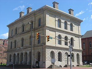
The National Register of Historic Places in the United States is a register including buildings, sites, structures, districts, and objects. The Register automatically includes all National Historic Landmarks as well as all historic areas administered by the U.S. National Park Service. Since its introduction in 1966, more than 90,000 separate listings have been added to the register.
Interstate 470 (I-470) is a 10.63-mile-long (17.11 km) auxiliary Interstate Highway of I-70 that bypasses the city of Wheeling, West Virginia, in the US. I-470 is one of 13 auxiliary Interstate Highways in Ohio and the only auxiliary Interstate Highway in West Virginia. The western terminus of I-470 is an interchange with I-70 in Richland Township, Ohio. Traveling southeast through rural Belmont County, I-470 approaches the Vietnam Veterans Memorial Bridge, which spans the Ohio River. After crossing the river into Ohio County, West Virginia, the highway turns east toward the Wheeling communities of Bethlehem and Elm Grove and its eastern terminus at I-70 near Elm Grove. The portion of the highway in West Virginia is named the USS West Virginia Memorial Highway by proclamation of then-Governor Cecil H. Underwood on the 59th anniversary of the attack on Pearl Harbor.
Lower Twin Island is a bar island on the Ohio River in the city of Wheeling, West Virginia. Lower Twin Island and its twin, Upper Twin Island, lie northwest of Wheeling's Warwood neighborhood.
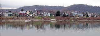
Wheeling Island is the most populated island in the Ohio River. It lies within the city of Wheeling in Ohio County, West Virginia, in the United States. The 2000 census showed a resident population of 3,142 people on the island, which has a land area of 1.514 square kilometres. Neville Island, Pennsylvania, is larger but has fewer people (1,232).
Transportation in West Virginia includes the following.

The Fort Henry Bridge is a crossing of the Ohio River main channel in Wheeling, West Virginia. The tied-arch bridge carries two lanes in each direction of Interstate 70 (I-70), U.S. Route 40 (US 40), and US 250. The bridge opened after four years of construction work on September 8, 1955, costing $6.8 million, $1.8 million over budget. The bridge, along with the aging Wheeling Suspension Bridge, are the only two road links from Wheeling Island to downtown Wheeling. In 2009, the structure carried an average of over 60,000 vehicles per day.

The Ohio River Islands National Wildlife Refuge (ORINWR) is a National Wildlife Refuge (NWR) in non-contiguous sites consisting of islands along 392 miles (631 km) of the Ohio River, primarily in the U.S. state of West Virginia. There are also two islands upstream in Beaver County, Pennsylvania, and a pair downstream in Lewis County, Kentucky. Going downstream, the refuge is currently located in parts of these counties: Beaver, Brooke, Ohio, Marshall, Wetzel, Tyler, Pleasants, Wood, Jackson, Mason, and Lewis. All counties are in West Virginia, with the exceptions in Pennsylvania and Kentucky mentioned above. The ORINWR was established in 1990 and consists of 3,354 acres (13.57 km2) of land and underwater habitat on 22 islands and four mainland properties. The refuge headquarters and visitor center is located in Williamstown, West Virginia.
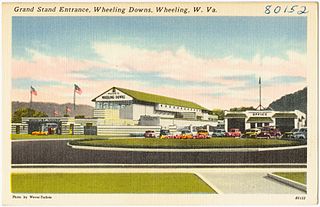
Wheeling Island Hotel-Casino-Racetrack is located on Wheeling Island in the middle of the Ohio River, which is a part of the city of Wheeling, West Virginia. It is located just off the Wheeling Island exit of I-70, 40 minutes west of Washington, Pennsylvania and about two hours east of Columbus, Ohio. It is owned by Delaware North.
Interstate 70 (I-70) is a portion of the Interstate Highway System that runs from near Cove Fort, Utah, at a junction with I-15 to Baltimore, Maryland. It crosses the Northern Panhandle of West Virginia through Ohio County and the city of Wheeling. This segment is the shortest of all states through which I-70 passes, crossing West Virginia for only 14.45 miles (23.26 km). The longest segment is Colorado's, which measures 451.04 miles (725.88 km). The Fort Henry Bridge carries I-70 from Wheeling Island across the Ohio River and into downtown Wheeling before the freeway enters the Wheeling Tunnel. I-470, a southerly bypass of Wheeling and the lone auxiliary Interstate Highway in West Virginia, is intersected near Elm Grove. Before crossing into Pennsylvania, I-70 passes The Highlands, a major shopping center in the panhandle, and the Bear Rocks Lake Wildlife Management Area. On average, between 27,000 and 53,000 vehicles use the freeway every day.
U.S. Route 250 (US 250) is a United States Numbered Highway that runs from Sandusky, Ohio, to Richmond, Virginia. Within the state of West Virginia, the route runs from the Ohio border in Wheeling to the Virginia border near Thornwood.
Wheeling Island Historic District is a national historic district located on Wheeling Island in Wheeling, Ohio County, West Virginia. The district includes 1,110 contributing buildings, 5 contributing sites, 2 contributing structures, and 3 contributing objects. It is a largely residential district consisting of two-story, frame detached dwellings built in the mid- to late-19th and early-20th century, including the Irwin-Brues House (1853) and a number of houses on Zane Street. The houses are representative of a number of popular architectural styles including Bungalow, Italianate, Queen Anne, and Colonial Revival. Notable non-residential contributing properties include the Exposition Building (1924), Thompson United Methodist Church (1913-1915), Madison School (1916), firehouse (1930-1931), the Bridgeport Bridge (1893), the Aetnaville Bridge (1891), "The Marina," Wheeling Island Baseball Park, and "Belle Island Park." It includes the separately listed Wheeling Suspension Bridge, Harry C. and Jessie F. Franzheim House, and John McLure House.
References
- ↑ Hay, Jerry M. (2007-12-01). Ohio River Guidebook. Inland Waterways Books. ISBN 978-1-60585-217-1.
| | This article about a location in Ohio County, West Virginia is a stub. You can help Wikipedia by expanding it. |