
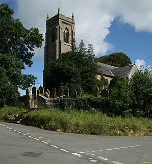
Upperby is a suburb of Carlisle, in the City of Carlisle district, in the English county of Cumbria. The ward population taken at the 2011 census was 5,476. [1] In 1870-72 the township/chapelry had a population of 595. [2]
Upperby is a suburb of Carlisle, in the City of Carlisle district, in the English county of Cumbria. The ward population taken at the 2011 census was 5,476. [1] In 1870-72 the township/chapelry had a population of 595. [2]
It is a few miles to the south-east of the city centre of Carlisle and is near the River Petteril.

Upperby has a park with a boating pool called Hammond's Pond which had originally been claypits known as "Clarty Dubs". What is now Scalegate Road was then known as "Black Lonning". [3]
St. Ninian's Well, a wellhead by Sara Losh on the site of an ancient well, located in Brisco and not in St. Ninian's Road as might at first be supposed. [4]
Upperby has a few schools:
Nearby settlements include the city of Carlisle, the residential area (suburb of Carlisle) of Harraby, Currock and Blackwell.
It may seem obvious that Upperby stands on a hill, but this is not in fact the origin of its name. If it were, the name would probably have been "Overby" (c.f. "Netherby"). In 1163 Upperby was a "byr" or farm in the hands of a man called Hubrecht who paid tithes to the Prior of Carlisle and Hubricteby appears in the Charter dealing with the Property and Revenues of the Priory of Carlisle. [5]
Portrait miniature painter, Thomas Heathfield Carrick (4 July 1802 - 1874) was born here.
Artist, Thomas Bushby (artist) (1861 - 1918) came to Carlisle in 1844 to work for Hudson Scott and Sons (now the Metal Box Company) as a designer. He painted in watercolours and exhibited at the Royal Academy. His paintings of local cottages featured in a series of coloured postcards printed by Chas. Thurnam of Carlisle, and numerous scenes around Carlisle were published as postcards in the "Dainty" series by ETW Dennis, including a set of six Lake District views. Perhaps he did not actually live in Upperby, but so many of his paintings feature scenes from Upperby, Brisco, Blackwell or Cummersdale as to suggest that he must have known these localities very well. [6]
Author and journalist, George MacDonald Fraser (2 April 1925 - 2 January 2008) was born and brought up in Currock, close enough to Upperby to be known locally as "Dr. Fraser's boy". He is best known for the Flashman series of novels, and Quartered Safe Out Here, an autobiography of his wartime experiences in Burma with the Border Regiment. After the war he was commissioned in the Gordon Highlanders and later was deputy editor of the Glasgow Herald.

Carlisle is a city in Cumbria, England. It is the county town and the administrative centre of the City of Carlisle district. Carlisle is located 8 miles (13 km) south of the Scottish border, and it is often referred to as a "border city". The city is located at the confluence of the rivers Eden, Caldew and Petteril. It is the largest settlement in the county of Cumbria and serves as the administrative centre for both Carlisle City Council and Cumbria County Council. Carlisle is also in the historic county of Cumberland. At the time of the 2001 census, the population of Carlisle was 71,773, with 100,734 living in the wider city. In the 2011 census, the city's population had risen to 75,306, with 107,524 in the wider city.

Aspatria is a civil parish in the non-metropolitan district of Allerdale, and is currently embraced in the Parliamentary constituency of Workington, Cumbria, England. Historically within Cumberland the town rests on the north side of the Ellen Valley, overlooking a panoramic view of the countryside, with Skiddaw to the South and the Solway Firth to the North. Its developments are aligned approximately east-west along the A596 Carlisle to Workington road and these extend to approximately 2 miles (3 km) in length. It lies about 8 miles (12 km) northeast of Maryport, a similar distance to the Southwest of Wigton, about 9 miles (14 km) north of Cockermouth and 5 miles (8 km) from the coast and Allonby. It comprises the townships of Aspatria and Brayton, Hayton and Mealo, and Oughterside and Allerby, the united area being 8,345 acres (3,377 ha); while the township takes up an area of 1,600 acres (647 ha). In earlier days a Roman road leading from "Old Carlisle" to Ellenborough passed through the hamlet.

Wooler is a small town in Northumberland, England. It lies on the edge of the Northumberland National Park, near the Cheviot Hills. It is a popular base for walkers and is referred to as the "Gateway to the Cheviots". As well as many shops and pubs, the town has a youth hostel, many hotels, and campsites. It lies on the St. Cuthbert's Way long-distance footpath between Melrose Abbey and Lindisfarne.

Carlisle is a constituency represented in the House of Commons of the UK Parliament since 2010 by John Stevenson of the Conservative Party.

Denton Holme is an inner city district in Carlisle, Cumbria, England. The population of this ward was 6,383 taken at the 2011 census.

Clifton is a small linear village and civil parish in Cumbria, England. Historically part of Westmorland, it lies 3 miles (4.8 km) south east of Penrith.

Garrigill, Cumbria is a small village in the North Pennine region of the UK, situated on the banks and close to the source of the River South Tyne. Historically part of Cumberland, today it is within the Garrigill ward of the civil parish of Alston Moor within the district of Eden. In 1870-72 the chapelry had a population of 1447.

Hesket is a large civil parish in the Eden District of Cumbria, England, on the main A6 between Carlisle and Penrith. At the 2001 census it had a population of 2,363, increasing to 2,588 at the 2011 census, and estimated at 2,774 in 2019. The parish formed in 1894 with the passing of the Local Government Act 1894 and was enlarged to incorporate the parish of Plumpton Wall following a County Review Order in 1934. Hesket is part of the historic royal hunting ground of Inglewood Forest. Settlement in the parish dates back to the Roman occupation.

St Cuthbert Without, or simply St Cuthbert, is a civil parish within the City of Carlisle in Cumbria, England.
Stanwix is a district of Carlisle, Cumbria in North West England. The ward population had a population taken at the 2011 census of 5,934. It is located on the north side of River Eden, across from Carlisle city centre. Although long counted as a suburb it did not officially become part of the city until 1912 when part of the civil parish of Stanwix became part of the parish, city and municipal borough of Carlisle. Further areas were added to the city, which was by then a county borough, in 1934 and 1951. The remaining part of the parish was eventually renamed Stanwix Rural in 1966.
Thursby is a village in the Allerdale borough of Cumbria, England. It is near to the city of Carlisle in North West England. Thursby was historically part of Cumberland.
Botcherby is a former village in Cumbria, England, now considered a suburb of the city of Carlisle. It is located east of the River Petteril south of its confluence with the River Eden, Cumbria.
Belle Vue is a suburb of Carlisle, Cumbria, United Kingdom. The ward population taken at the 2011 census was 6,491.

Dalston is a large village and civil parish within the Carlisle district of Cumbria, historically part of Cumberland. It is situated on the B5299 road 4 miles (6 km) south-south-west of Carlisle city centre, and approximately 5 miles (8 km) from Junction 42 of the M6 motorway.

Harvey Goodwin was an English academic and Anglican bishop, Bishop of Carlisle from 1869 until his death.

Holme St Cuthbert is a small village and civil parish in the borough of Allerdale, in the county of Cumbria, United Kingdom. The village is located approximately 23 miles to the south-west of Carlisle, Cumbria's county town, and was historically in the county of Cumberland.

Brisco or Birksceugh is a village in the civil parish of St Cuthbert Without, in the Carlisle district, in the county of Cumbria, England. It is located a few miles south of the city of Carlisle, near Junction 42 of the M6 motorway. There is St Ninian's well in the village. In the Imperial Gazetteer of England and Wales of 1870-72 the township had a population of 323.

Holme St. Cuthbert School is a primary school which serves the civil parish of Holme St. Cuthbert in the county of Cumbria, United Kingdom. It is located approximately one-and-a-quarter miles north-east of the village of Mawbray, the largest settlement in the parish, and twenty-three miles south-west of the city of Carlisle, Cumbria's county town. As of the 2018-19 academic year, there were sixty-two pupils enrolled in the school. This is just short of the school's capacity of sixty-six pupils. The current headteacher is Mrs Lynn Carini, who took over from Mrs Sheila Daniel in 2014.
St Cuthbert Without is a civil parish in the Carlisle district of Cumbria, England. It contains 43 listed buildings that are recorded in the National Heritage List for England. Of these, two are listed at Grade II*, the middle of the three grades, and the others are at Grade II, the lowest grade. The parish includes the southern suburbs of Carlisle including Garlands, and the villages of Blackwell, Brisco, Carleton, and Wreay, together with the surrounding countryside. Most of the listed buildings are country houses, smaller houses and associated structures, farmhouses, and farm buildings. The other listed buildings include a church and associated structures, a former mortuary chapel, a former hospital chapel, and a well head.