
The Upton Clock Tower is a landmark in Upton, Dorset.
The Upton Clock Tower is a landmark in Upton, Dorset.
The clock tower was built to celebrate the new millennium in 2000.
In 2014, a Armistice Day plaque was added to the side of the clock tower. [1]
In April 2024, an ornamental beehive was stolen from the clock tower. [2]

Tower Park is a leisure and retail park, located at Mannings Heath, in Poole, Dorset, England. It was one of the first complexes of its kind in Europe when it opened in 1989.

Upton is a town in south-east Dorset, England. Upton is to the east of Holton Heath and Upton Heath, and to the north of the Poole suburb of Hamworthy. It is the second largest town in the Purbeck Hills.
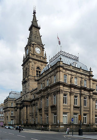
Municipal Buildings is a former council office building that has been converted into a hotel. It is located on Dale Street in the centre of Liverpool, England. It is a Grade II* listed building.

The Rugby Central Shopping Centre is a two-storey shopping precinct in the town centre of Rugby, Warwickshire, England, managed by CBGA Robson LLP. The precinct includes clothes stores, game shops, thrift stores and food outlets. There is a large multi-storey car park at the rear and the towns main bus stops are at the front of the centre. The centre is visited by 100,000 people per week, and has more than 50 outlets.

Creekmoor is a suburb of Poole in Dorset, England, with a population of 9,257, reducing to 9,180 at the 2011 census. Bordered by the Upton Heath Nature Reserve and Upton Country Park, the area is mainly populated by families. The suburb is represented by two local councillors, Judy Butt of the Poole Engage Party and Paul Slade of the Liberal Democrats.
Woodchurch is a proposed railway station situated between Upton and Heswall on the Borderlands Line.

Lansdowne is a suburb of Bournemouth. It occupies the north-east part of the main built-up area around Bournemouth Town Centre.

East Cliff is a suburb and ward in Bournemouth, Dorset, England.

West Cliff is a suburb of Bournemouth, Dorset, England. West Cliff is south of Westbourne and east of Branksome in Poole.

Townsend is a area of Bournemouth, Dorset. It is located in the suburbs along the north eastern boundary of the town and is close to the Royal Bournemouth Hospital.

Talbot Woods is an area of Bournemouth, Dorset. Talbot Woods is south of Talbot Village.
Northbourne is a suburb of Bournemouth, Dorset in England. It is in the north of the town and borders Ensbury Park.

Strouden Park or Strouden is an area of Bournemouth, Dorset, England.

Bournemouth Town Centre is an area of Bournemouth, Dorset. The town centre is the central business district and is located near the coast between West Cliff and East Cliff.

Alder Hills is a suburb in Dorset that crosses the boundaries of Bournemouth and Poole. It is south of Wallisdown, east of Alderney and north of Parkstone.

The Royal Bath Hotel is a building in Bournemouth, Dorset. It is owned by Britannia Hotels and is regarded to be the town's most famous hotel. Since 1974, the hotel has been a Grade II listed building. The hotel was formerly owned by the Mayor of Bournemouth, Merton Russell-Cotes.

Meyrick Park is a suburb and area of Bournemouth, Dorset. The park itself features a main field with rugby pitches, surrounded by elevated woodland on both sides and a golf course around the western side. Dog-walking is permitted on both, and the paved path along the main field is often used to get to the town centre.

Purewell is an area of Christchurch, Dorset.

St Mark's Church is a Victorian Church of England parish church and listed building in Bournemouth, England.

St Alban's Church is a Grade II listed Gothic Revival Anglican church in the Charminster area of Bournemouth, Dorset, England. The church stands across Charminster Road from the Church of the Annunciation.
50°44′19″N2°01′45″W / 50.7386°N 2.0293°W
| | This article about a United Kingdom building or structure is a stub. You can help Wikipedia by expanding it. |
| | This Dorset location article is a stub. You can help Wikipedia by expanding it. |