
Rockall is an uninhabitable granite islet in the exclusive economic zone (EEZ) of the United Kingdom, situated in the North Atlantic Ocean. It is claimed by the United Kingdom as its territory. This claim is not recognised by its neighbours.

Jefferson County is a county on the northern border of the U.S. state of New York. As of the 2010 census, the population was 116,229. Its county seat is Watertown. The county is named after Thomas Jefferson, third President of the United States of America. It is adjacent to Lake Ontario, southeast from the Canada–US border of Ontario.
Herm is one of the Channel Islands and part of the Parish of St Peter Port in the Bailiwick of Guernsey. It is located in the English Channel, north-west of France and south of England. It is 2.183 kilometres (1.4 mi) long and under .873 kilometres (0.5 mi) wide; orientated north–south, with several stretches of sand along its northern coast. The much larger island of Guernsey lies to the west and Jersey to the south-east, and the smaller island of Jethou is just off the south-west coast.

The Karimata Strait also spelled Carimata or Caramata is the wide strait that connects the South China Sea to the Java Sea, separating the Indonesian islands of Sumatra and Borneo (Kalimantan). It is bordered by the Belitung island in the west and Borneo in the east. It is the widest strait that connects the South China Sea and the Java Sea, but its numerous islands and reefs reduce its navigability. Its weather and current is influenced by the annual southeast and northwest monsoon.
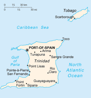
Trinidad is the larger and more populous of the two major islands of Trinidad and Tobago. The island lies 11 km (6.8 mi) off the northeastern coast of Venezuela and sits on the continental shelf of South America. It is often referred to as the southernmost island in the Caribbean. With an area of 4,768 km2 (1,841 sq mi), it is also the fifth largest in the West Indies.

A pole of inaccessibility with respect to a geographical criterion of inaccessibility marks a location that is the most challenging to reach according to that criterion. Often it refers to the most distant point from the coastline, implying a maximum degree of continentality or oceanity. In these cases, pole of inaccessibility can be defined as the center of the largest circle that can be drawn within an area of interest without encountering a coast. Where a coast is imprecisely defined, the pole will be similarly imprecise.

Ducie Island is an uninhabited atoll in the Pitcairn Islands. It lies 575 kilometres (357 mi) east of Pitcairn Island, and 300 kilometres (190 mi) east of Henderson Island, and has a total area of 1.5 square miles (3.9 km2), which includes the lagoon. It is 1.5 miles (2.4 km) long, measured northeast to southwest, and about 1 mile (1.6 km) wide. The island is composed of four islets: Acadia, Pandora, Westward and Edwards.

Hurricane Cesar–Douglas was one of the few tropical cyclones to survive the crossover from the Atlantic to east Pacific basin, and was the last to receive two names upon doing so. Cesar was the third named storm and second hurricane of the 1996 Atlantic hurricane season. The system formed in the southern Caribbean Sea and affected several countries in South America before crossing Nicaragua and entering the eastern Pacific where it was renamed Douglas. The storm killed 113 people in Central and South America and left 29 others missing, mainly due to flooding and mudslides.

Snares Islands/Tini Heke, also known as The Snares, is a small group of uninhabited islands lying about 200 km south of New Zealand's South Island and to the south-southwest of Stewart Island/Rakiura. The Snares consist of the main North East Island and the smaller Broughton Island as well as the Western Chain Islands some 5 km (3.1 mi) to the west-southwest. Collectively, the Snares have a total land area of 3.5 km2 (1.4 sq mi).

The Caribbean Plate is a mostly oceanic tectonic plate underlying Central America and the Caribbean Sea off the north coast of South America.
The North American Cordillera is the North American portion of the American Cordillera which is a mountain chain (cordillera) along the western side of the Americas. The North American Cordillera covers an extensive area of mountain ranges, intermontane basins, and plateaus in western North America, including much of the territory west of the Great Plains. It is also sometimes called the Western Cordillera, the Western Cordillera of North America, or the Pacific Cordillera.

HMAS Torrens, named for the River Torrens, was a River-class torpedo-boat destroyer of the Royal Australian Navy (RAN). The destroyer was built at Cockatoo Island Dockyard and entered service with the RAN in 1916. The destroyer was first deployed to East Asia, then the Mediterranean, where she remained for the rest of World War I. After returning to Australia, the destroyer was decommissioned, but saw use in several ports for reservist training before the decision to sell her for scrap was made. After being stripped, the destroyer was towed outside Sydney Heads, used for gunnery practice, and scuttled.

Tryal Rocks, sometimes spelled Trial Rocks or Tryall Rocks, formerly known as Ritchie's Reef or Greyhound's Shoal, is a reef of rock located in the Indian Ocean off the northwest coast of Australia, 14 kilometres (8.7 mi) northwest of the outer edge of the Montebello Islands group. It is named for the Tryall, the first known shipwreck in Australian waters, which sunk after striking the then-uncharted rocks in 1622. Described as "the theme and dread of every voyager to the eastern islands", their location was sought for over three centuries before finally being determined in 1969.

Dampier Strait in Papua New Guinea separates Umboi Island and New Britain, linking the Bismarck Sea to the north with the deeper Solomon Sea to the south.

The islands and reefs of the Capricorn and Bunker Group are situated astride the Tropic of Capricorn at the southern end of the Great Barrier Reef, approximately 80 kilometres east of Gladstone, which is situated on the central coast of the Gladstone Region, Queensland, Australia.

The Alhambra was an iron steamer screw built in 1853 by Samuda Brothers at Cubitt Town, London. It was wrecked in a collision off Newcastle, near Nobbys Head, New South Wales, on 30 June 1888.
SS Bonnie Dundee was a 193/121-gross-ton Australian steamship which sank after a collision with the steamship SS Barrabool off Lake Macquarie, New South Wales, Australia, on 10 March 1879.

Chissioua Mtsamboro, widely known previously as Zamburu Island, also Saddle Island, is an island, about 3 miles off the northwest coast of Mayotte in the Indian Ocean in the Comoros archipelago. It lies north of the Choazil Islands, just off the coast of Mtsamboro. This stretch of water is known as the Zamburu Passage, part of the Mozambique Channel. Chissiou Mtsamboro is a mountainous island covering 2 square kilometres, providing shelter to the main stretch of beach, tucked away in the southwest of the island which contains a main settlement and numerous huts dotted along the beach. Its highest point reaches an altitude of 273 metres. The soundings close to the reef which surrounds the island is from 10 to 15 fathoms.

Ataliklikun Bay is a bay of East New Britain Province, Papua New Guinea, opening into the Bismarck Sea. It is located in the northern part of New Britain, south-west of Lassul Bay and to the west of Cape Lambert and Rabaul. Urara Island is located in the northern part of the bay. The Raulavat plantation lies in the eastern part of its 25-mile shoreline. The villagers along the shore reportedly speak the Minigir language and the Masava dialect of Tolai. The United States Hydrographic Office said "a reef awash, about 200 yards long east and west, with 15 and 19 fathoms around, on which the steamer Seestem struck in 1909, lies in the south-west part of Ataliklikun Bay."

Watom Island is an inhabited island in the Bismarck Sea in Papua New Guinea, located just off the mainland of the northern coast of New Britain, near Rabaul. It lies to the north-east of Urara Island. The island is almost entirely forested except for a few scattered settlements. The highest point of the island is approaching 320 metres. Watom's Wall, a "classic wall dive well", located on the northern coast, is a notable diving location.

