
Copenhagen is the capital and most populous city of Denmark. As of 1 January 2020, the city had a population of 794,128 with 632,340 in Copenhagen Municipality, 104,305 in Frederiksberg Municipality, 42,989 in Tårnby Municipality, and 14,494 in Dragør Municipality. It forms the core of the wider urban area of Copenhagen and the Copenhagen metropolitan area. Copenhagen is situated on the eastern coast of the island of Zealand; another portion of the city is located on Amager, and it is separated from Malmö, Sweden, by the strait of Øresund. The Øresund Bridge connects the two cities by rail and road.

Aarhus Municipality, previously known as Århus Municipality until 2011, is a municipality in Central Denmark Region, on the east coast of the Jutland peninsula in central Denmark.
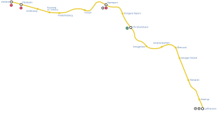
M2 is a line of the Copenhagen Metro, colored yellow on the map. It runs from Vanløse to Lufthavnen through the center of Copenhagen, sharing track with the M1 from Vanløse to Christianshavn. The line was built along with M1 as part of the redevelopment of Ørestad. The principle of the line was passed in 1992, and construction commenced in 1998. The line opened in several stages between 2002 and 2007. It is owned by Metroselskabet and operated by Metro Service, and operates with a headway between four and twenty minutes.

Indre By, also known as Copenhagen Center or K or Downtown Copenhagen, is an administrative district (by) in central Copenhagen, the capital of Denmark. It covers an area of 4.65 square kilometres (1.80 sq mi), has a population of 26,223, and a population density of 5,638 per km².

Indre Østerbro, is one of the 15 administrative, statistical, and tax city districts ("bydele") comprising the municipality of Copenhagen, Denmark. It lies on the eastern edge of the municipality. It covers an area of 6.76 km², has a population of 46,095 and a population density of 6,817 per km².

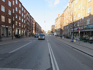
Vesterbro is one of the 15 administrative, statistical, and city tax districts (bydele) comprising the municipality of Copenhagen, Denmark. It covers an area of 3.76 km², and has a population of 51,466 and a population density of 13,688 per km².

Kongens Enghave, commonly known as Sydhavnen or the postal district of 2450 Copenhagen SV (southwest) is a district in southern Copenhagen. While its core is a largely pre-WWII former working class district, it also contains an upscale residential area along the harbour having been developed after 2000, scattered industrial areas, large parks such as Valbyparken and Sydhavnstippen, allotment gardens and parts of Vestre Kirkegård, the city's largest cemetery.

Valby (help·info) is one of the 10 official districts of Copenhagen, Denmark. It is in the southwestern corner of Copenhagen Municipality, and has a mixture of different types of housing. This includes apartment blocks, terraced housing, areas with single-family houses and allotments, plus the remaining part of the old Valby village, around which the district has formed, intermingled with past and present industrial sites.

Copenhagen Municipality, also known in English as the Municipality of Copenhagen, located in the Capital Region of Denmark, is the largest of the four municipalities that constitute the City of Copenhagen, the other three being Dragør, Frederiksberg, and Tårnby. The Municipality of Copenhagen constitutes the historical city center and the majority of its landmarks. It is the most populous in the country with a population of 637,936 inhabitants, and covers 86.4 square kilometres (33.4 sq mi) in area,. Copenhagen Municipality is located at the Zealand and Amager islands and totally surrounds Frederiksberg Municipality on all sides. The strait of Øresund lies to the east. The city of Copenhagen has grown far beyond the municipal boundaries from 1901, when Frederiksberg Municipality was made an enclave within Copenhagen Municipality.

Vesterbro is a neighbourhood of Aarhus, Denmark. It is located in the Aarhus C district, west of the city centre of Indre By. Vesterbro used to be farmland outside the city walls, and the neighbourhood's development progressed, when the city walls of Aarhus were demolished in 1851.

Vesterbro/Kongens Enghave is one of the 10 official districts of Copenhagen, Denmark. The district has an area of 8.22 km² and a population of 53,351.
Districts of Copenhagen are often based on informal designations based on historic origins, often with alternative names and loosely defined boundaries. Copenhagen Municipality is divided into 10 official administrative districts but they often comprise areas of a heterogeneous character which are colegually not seen as one district. Some districts have earlier been official subdivisions and thus have semi-official boundaries. Copenhagen postal code designations often correspond to district boundaries but in some cases differ from them, as an example parts of the city centre has the postal code København V which is generally associated with Vesterbro.
Enghave Plads is a central public square of the Vesterbro district in Copenhagen, Denmark. It is located where Istedgade reaches Enghavevej, which separates the square from Enghave Park.

Nørre Stenbro is a small neighborhood in the city of Aarhus, Denmark home to some 3,000 residents. The neighborhood is part of the Aarhus C district and borders the neighborhoods of Indre By south and west, Aarhus Docklands in the east and Trøjborg north. The residential area of Nørre Stenbro is delimited by the streets Nørre Boulevard, Østboulevarden, Østbanetorvet, Kystvejen, Nørreport and Nørrebrogade, but the large Nordre Cemetery and the smaller residential quarter of Skovvejskvarteret is also part of the same registration.
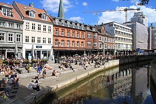
Indre By is a neighborhood in the city of Aarhus, Denmark. The neighborhood is bounded by Nørre Allé, Vester Allé and Sønder Allé and is composed of the neighborhood and historical centre of the Latin Quarter and the areas around the Central Station and the City Hall Park. The neighborhood is one of the three main neighborhoods in the district of Aarhus C, along with Frederiksbjerg and Vesterbro.
Aarhus Municipality is divided in many different ways, often on layered levels. Politically it is a part of the multi-member constituency Østjyllands Storkreds which covers the eastern coast of East Jutland from Randers to Vejle Fjord. Aarhus Municipality itself is divided in 4 folketing constituencies, Århus Sydkredsen, Århus Vestkredsen, Århus Nordkredsen, Århus Østkredsen, which are again divided in a total of 45 wards, each with one polling station. The diocese of Aarhus is divided in a number of deaneries of which 4 resides in Aarhus Municipality with a total of 58 parishes. Administratively Aarhus Municipality operates with 25 districts or local communities (Lokalsamfund) which can be amalgamations of parishes, neighborhoods or former and present towns. In addition there are 28 postal districts within the municipality, some of which are colloquially used to denote areas and neighborhoods in the city of Aarhus. The urban area and immediate suburbs of the city of Aarhus are divided in the postal (P.D.) districts Aarhus C, Aarhus N, Aarhus V, Viby J, Højbjerg, Brabrand and Risskov.

Carlsberg station is an S-train station in Copenhagen, Denmark, that serves the Carlsberg area of the Vesterbro/Kongens Enghave district. Situated on the Høje Taastrup radial of the S-train network, it opened on 3 July 2016 and replaced Enghave station, which was located 200m east.
Enghavevej is a major street in the Vesterbro and Kongens Enghave districts of Copenhagen, Denmark. It runs from Vesterbrogade in the north to Sydhavns Plads in the south, linking Kingosgade with Sydhavnsgade and Borgbjergsvej.
