Ibarra is a town and municipality located in the province of Gipuzkoa, in the autonomous community of Basque Country, northern Spain. By 2003 INE figures Ibarra had a total population of 4,374.

Buckland Monachorum is a village and civil parish in the West Devon district of Devon, England, situated on the River Tavy, about 10 miles north of Plymouth.

Ulubey is a town and district of Ordu Province in the Black Sea region of Turkey, 21 km (13 mi) south of the Black Sea in the Pontic Mountains. The Melet River runs through the district. According to the 2000 census, population of the district is 29,227 of which 9,128 live in the town of Ulubey. The district covers an area of 304 km2 (117 sq mi), and the town lies at an elevation of 602 m (1,975 ft).

Głaznów is a village in the administrative district of Gmina Krośniewice, within Kutno County, Łódź Voivodeship, in central Poland. It lies approximately 3 kilometres (2 mi) west of Krośniewice, 17 km (11 mi) west of Kutno, and 57 km (35 mi) north-west of the regional capital Łódź.
Zasów is a village in the administrative district of Gmina Żyraków, within Dębica County, Subcarpathian Voivodeship, in south-eastern Poland. It lies approximately 7 kilometres (4 mi) north-west of Żyraków, 11 km (7 mi) north-west of Dębica, and 49 km (30 mi) west of the regional capital Rzeszów.
Brzeście is a village in the administrative district of Gmina Wodzisław, within Jędrzejów County, Świętokrzyskie Voivodeship, in south-central Poland. It lies approximately 5 kilometres (3 mi) west of Wodzisław, 18 km (11 mi) south-west of Jędrzejów, and 54 km (34 mi) south-west of the regional capital Kielce.
Winna is a village in the administrative district of Gmina Łagów, within Kielce County, Świętokrzyskie Voivodeship, in south-central Poland. It lies approximately 4 kilometres (2 mi) east of Łagów and 39 km (24 mi) east of the regional capital Kielce.
Gatniki is a village in the administrative district of Gmina Końskie, within Końskie County, Świętokrzyskie Voivodeship, in south-central Poland. It lies approximately 9 kilometres (6 mi) south-west of Końskie and 33 km (21 mi) north-west of the regional capital Kielce.
Białki is a village in the administrative district of Gmina Siedlce, within Siedlce County, Masovian Voivodeship, in east-central Poland. It lies approximately 5 kilometres (3 mi) south of Siedlce and 89 km (55 mi) east of Warsaw.
Lipiny is a village in the administrative district of Gmina Zbuczyn, within Siedlce County, Masovian Voivodeship, in east-central Poland.

Sınıqkilsə is a village in the Kalbajar Rayon of Azerbaijan.
Bronisław is a village in the administrative district of Gmina Krzykosy, within Środa Wielkopolska County, Greater Poland Voivodeship, in west-central Poland.
Dąbrowa Puzdrowska is a village in the administrative district of Gmina Sierakowice, within Kartuzy County, Pomeranian Voivodeship, in northern Poland. It lies approximately 3 kilometres (2 mi) south-west of Sierakowice, 22 km (14 mi) west of Kartuzy, and 50 km (31 mi) west of the regional capital Gdańsk.
Pieniężno Drugie is a village in the administrative district of Gmina Pieniężno, within Braniewo County, Warmian-Masurian Voivodeship, in northern Poland.
Krupá is a village and municipality in Kolín District in the Central Bohemian Region of the Czech Republic.

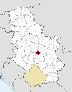
Ursule is a village in Šumadija and Western Serbia (Šumadija), in the municipality of Rekovac, lying at 43°52′34″N21°08′01″E, at the elevation of 215 m. According to the 2002 census, the village had 400 citizens.
Krstićevo is a village in the municipality of Crna Trava, Serbia. According to the 2002 census, the village has a population of 24 people.
Donje Trnjane is a village in the municipality of Leskovac, Serbia. According to the 2002 census, the village has a population of 289 people.

Sendići is a village in the municipality of Višegrad, Bosnia and Herzegovina.
Lhotka u Litultovic is a village in the Moravian-Silesian Region of the Czech Republic. As of March 7, 2006, the population was 181.