U.S. Route 163 is a 64-mile (103 km) U.S. Highway that runs from US 160 northward to US 191 in the U.S. states of Arizona and Utah. The southernmost 44 miles (71 km) of its length are within the Navajo Nation. The highway forms part of the Trail of the Ancients, a National Scenic Byway. The highway cuts through the heart of Monument Valley and has been featured in numerous movies and commercials.
State Route 12 or Scenic Byway 12 (SR-12), also known as "Highway 12 — A Journey Through Time Scenic Byway", is a 122.863-mile-long (197.729 km) state highway designated an All-American Road located in Garfield County and Wayne County, Utah, United States.
State Route 112 is a state highway and scenic byway in the U.S. state of Washington. It runs east–west for 61 miles (98 km) along the Strait of Juan de Fuca in Clallam County, connecting the Makah Indian Reservation near Neah Bay to U.S. Route 101 (US 101) near Port Angeles.
State Route 67 is a 43.4 mi (69.8 km) long, north–south state highway in northern Arizona. Also called the Kaibab Plateau – North Rim Parkway, SR 67 is the sole road that links U.S. Route 89A at Jacob Lake to the North Rim of Grand Canyon National Park. Along the route, the road heads through the national park as well as Kaibab National Forest and is surrounded by evergreen trees. The section inside the national park is maintained by the National Park Service (NPS), whereas the section north of the entrance, completely within Kaibab National Forest, is owned by the Arizona Department of Transportation (ADOT). The road was built in the late 1920s and improved through the 1930s. In 1941, the road received its number, and was given its designation as the parkway in the 1980s. The parkway has received designations as a National Forest Scenic Byway as well as a National Scenic Byway.
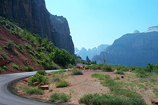
State Route 9 (SR-9) is a 57.075-mile-long (91.853 km) state highway in southern Utah, serving Zion National Park. It starts at the western terminus at exit 16 on Interstate 15 (I-15), passing through Zion National Park, and ending at the eastern junction with U.S. Route 89 (US-89). The entire length of the highway has been designated the Zion Park Scenic Byway. There is a fee to travel through Zion National Park, but the Zion-Mt. Carmel Highway is open to private vehicles year-round. A separate fee is required for vehicles 7'10" wide and/or 11'4" tall or larger. This fee pays for a park employee to stop traffic from the other side of the Zion - Mt. Carmel Tunnel to allow the larger vehicles to pass through. There is a smaller tunnel in Zion National Park that does not require an escort. Commercial vehicles are prohibited from using SR-9 and are directed to use SR-20 instead.
State Route 313 (SR-313) is a 22.506-mile-long (36.220 km) state highway in San Juan and Grand Counties in the U.S. State of Utah. The highway has been designated the Dead Horse Point Mesa Scenic Byway. The highway is an access road for both the Island in the Sky district of Canyonlands National Park and Dead Horse Point State Park. The highway is a toll road in Dead Horse Point State Park. Westbound traffic is charged a state park entrance fee at the park boundary.

State Route 279 is a state highway in the U.S. state of Utah. The highway was constructed in 1962–1963 to service the Cane Creek potash mine and processing plant southwest of Moab. The highway was named one of the most beautiful highways opened to traffic in 1963. The entire length of SR-279 has been designated the Potash – Lower Colorado River Scenic Byway by the Utah State Legislature, however is known locally as Potash Road.
State Route 132 (SR-132) is a 63.132-mile-long (101.601 km) state highway in the U.S. state of Utah. It connects U.S. Route 6 (US-6) in Lynndyl to US-89 at Pigeon Hollow Junction, crossing Interstate 15 (I-15) in Nephi.
U.S. Route 89 in the U.S. state of Utah is a north–south United States Highway spanning more than 502 miles (807.891 km) through the central part of the state, making it the longest road in Utah. Between Provo and Brigham City, US-89 serves as a local road, paralleling Interstate 15, but the portions from Arizona north to Provo and Brigham City northeast to Wyoming serve separate corridors. The former provides access to several national parks and Arizona, and the latter connects I-15 with Logan, the state's only Metropolitan Statistical Area not on the Interstate.

The Dinosaur Diamond Prehistoric Highway is a 512-mile-long (824 km) National Scenic Byway in the U.S. states of Utah and Colorado. The highway forms a diamond-shaped loop with vertices at Moab, Helper, Vernal and Grand Junction.
State Route 92 (SR-92), also known in various portions as the Timpanogos Highway, and Alpine Loop Scenic Highway is a scenic state highway in Utah County, Utah that runs from I-15/US-89 in Lehi to US-189 in Provo Canyon. The route is 27.296 miles (43.929 km) long and is the only road with access to Sundance Ski Resort and the Aspen Grove Family Camp and Conference Center.
State Route 14 (SR-14) is a state highway in southern Utah, running for 40.995 miles (65.975 km) in Iron and Kane Counties from Cedar City to Long Valley Junction. The highway has been designated the Markagaunt High Plateau Scenic Byway as part of the Utah Scenic Byways program.
State Route 39 (SR-39) is a state highway in northern Utah connecting Ogden to Woodruff via Ogden Canyon and Huntsville. The highway is on 12th Street in Ogden and the Ogden River Scenic Byway through Ogden Canyon. The route is over sixty-seven miles long.
State Route 44 (SR-44) is a state highway in the U.S. state of Utah that runs from US-191 at Greendale Junction, southwest of Dutch John, to SR-43 in Manila. The route spans 27.99 miles (45.05 km) as it straddles the southern and western border of the Flaming Gorge National Recreation Area, and, along with US-191 is part of the Flaming Gorge-Uintas Scenic Byway.

State Route 143 (SR-143) is a state highway in the U.S. state of Utah. The entire highway has been designated the Brian Head-Panguitch Lake Scenic Byway as part of the Utah Scenic Byways program. This road has also been designated as Utah's Patchwork Parkway as part of the National Forest Scenic Byway program.
State Route 153 (SR-153) is a state highway in the U.S. state of Utah. Just over half of the western portion of the highway has been designated the Beaver Canyon Scenic Byway as part of the Utah Scenic Byways and National Forest Scenic Byways programs.

The Trail of the Ancients is a National Scenic Byway located in the states of Colorado and Utah. The route highlights the archaeological and cultural history of southwestern Native American peoples, and traverses the widely diverse geological landscape of the Four Corners region of the Colorado Plateau. It was the first National Scenic Byway that was designated solely for its archaeological sites. The entire route is approximately 480 miles (772.5 km) long.
State Route 146 (SR-146) was a state highway in the U.S. state of Utah that connected the city of Pleasant Grove with SR-92 at the mouth of American Fork Canyon, some 5.3 miles (8.5 km) to the north in Utah County.
Utah State Route 158 is a state highway in the U.S. state of Utah. Spanning 11.6 miles (18.7 km), it connects Powder Mountain Ski Resort and the towns of Liberty and Eden with Utah State Route 39 in Ogden Canyon in Weber County. A portion of the road is designated as part of the Ogden River Scenic Byway.


