Gloppen is a municipality in the county of Sogn og Fjordane, Norway. It is located in the traditional district of Nordfjord. Gloppen is generally subdivided into three areas: Hyen in the west, Gloppen in the center, and Breim in the east.

Stryn is a municipality in the county of Sogn og Fjordane, Norway. It is located in the traditional district of Nordfjord. The administrative center of the municipality is the village of Stryn. The municipality is located along the innermost part of the Nordfjorden. Some of the main villages in Stryn include Loen, Innvik, Utvik, Randabygda, Olden, and Flo.

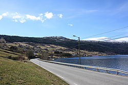
Oppstrynsvatn is a lake in the municipality of Stryn in Sogn og Fjordane county, Norway. It is located about 8 kilometres (5.0 mi) east of the village of Stryn. The villages of Flo, Oppstryn, and Erdal are located on the shores of the lake.

Lote is a village in the municipality of Eid in Sogn og Fjordane county, Norway. The population of Lote (2001) was 132. The village is located about 8 kilometres (5.0 mi) southeast of the village of Nordfjordeid and about 13 kilometres (8.1 mi) northwest of Sandane in Gloppen Municipality. The 2.9-kilometre (1.8 mi) Lote Tunnel is a tunnel along the European route E39 that goes through a mountain north of Lote. The tunnel connects Lote with the rest of Eid municipality.

Innvik is a former municipality in Sogn og Fjordane county in Norway. Innvik is located in the present-day Stryn Municipality, encompassing about the western third of the present municipality. Innvik included both sides of the Nordfjorden, from Randabygda in the west to just west of the village of Stryn. It stretched from the border with Hornindal Municipality in the north, through the Oldedalen valley all the way to the Jostedalsbreen glacier in the south.

Loen is a village in Stryn Municipality in Sogn og Fjordane county, Norway. It is located in the inner part of the Nordfjord region, at the easternmost end of the Nordfjorden. Loen is located about 6 kilometres (3.7 mi) north of the village of Olden and about 11 kilometres (6.8 mi) southeast of the municipal center of Stryn. The lake Lovatnet is located just to the southeast of the village of Loen. The Hotel Alexandra was established in Loen in 1884. The historic Loen Church is also located in the village.

Lovatnet is a lake in the municipality of Stryn in Sogn og Fjordane county, Norway. It is located about 2 kilometres (1.2 mi) southeast of the village of Loen and about 6 kilometres (3.7 mi) east of the village of Olden. The lake lies just 2 kilometres (1.2 mi) southwest of the mountain Skåla. The water from the lake flows down from the mountains; especially from the Jostedalsbreen and Tindefjellbreen glaciers. It then flows out through the Loelva river into the Nordfjorden.
Stårheim is a village in the municipality of Eid in Sogn og Fjordane county, Norway. The population (2001) of the area was 439 people. Stårheim is located in the western part of Eid Municipality on the north shore of the Nordfjorden, about 12 kilometres (7.5 mi) west of the municipal center of Nordfjordeid and about 8 kilometres (5.0 mi) east of the village of Kjølsdalen. There is a regularly scheduled ferry route from Stårheim to the small village of Isane, located about 4 kilometres (2.5 mi) south across the Nordfjorden.
Isane is a village in Bremanger Municipality in Sogn og Fjordane county, Norway. It has a ferry connection to the village of Stårheim which is about 4 kilometres (2.5 mi) northeast across the Nordfjorden. The population (2001) of Isane is 42. Since 2006, the village has become an important seaport for importing yellowfin tuna.
Ålfoten is a village in Bremanger Municipality in Sogn og Fjordane county, Norway. The village is located along the Ålfotfjorden, a branch off the south side of the main Nordfjorden. The population (2001) of the village is 181. The village has an elementary school and the Ålfoten Church which was built in 1678. The village was part of the (former) municipality of Davik until 1965 when it was incorporated into Bremanger.
Olden is a village and urban area in the municipality of Stryn in Sogn og Fjordane county, Norway. Olden is located at the mouth of the Oldeelva river at the northern end of the Oldedalen valley on the southern shore of the Nordfjorden. The 0.57-square-kilometre (140-acre) village has a population (2013) of 498, giving the village a population density of 874 inhabitants per square kilometre (2,260/sq mi). Olden is located about 6 kilometres (3.7 mi) southwest of the village of Loen, about a 16 kilometres (9.9 mi) drive southeast of the municipal center of Stryn, and about 15 kilometres (9.3 mi) east of the village of Innvik.

Oldedalen is a river valley in Stryn Municipality in Sogn og Fjordane county, Norway. The 20-kilometre (12 mi) long valley runs north-south and ends at the Nordfjorden at the village of Olden. The south end of the valley reaches up to the great Jostedalsbreen glacier inside Jostedalsbreen National Park. The small Briksdalsbreen is a smaller arm that branches off the main Jostedalsbreen glacier, and it sits at the end of the Oldedalen valley. It is a tourist attraction due to its easy to reach location. The western side of the valley is a fairly steep wall of mountains with the Myklebustbreen glacier at the top.
Innvik is a village in Stryn Municipality in Sogn og Fjordane county, Norway. The village is located on the southern shore of the Nordfjorden. The village is located about 15 kilometres (9.3 mi) west of the village of Olden and about 7 kilometres (4.3 mi) northeast of the village of Utvik. Directly across the fjord from Innvik lies the village of Roset.

Stryn is the administrative centre of Stryn Municipality in Sogn og Fjordane county, Norway. The village is located on the shore of a small bay off of the main Nordfjorden. The mouth of the river Stryneelva is in the village. The village sits about 3.5 kilometres (2.2 mi) west of the village of Nedstryn.
Roset or Nordsida is a village in Stryn Municipality in Sogn og Fjordane county, Norway. The village is located on the northern shore of the Nordfjorden. The village is located about 15 kilometres (9.3 mi) east of the village of Randabygda and about 15 kilometres (9.3 mi) west of the village of Stryn. The village of Innvik lies directly across the Nordfjorden from Roset. Nordsida Church is located in Roset.

Randabygda or Hopland is a village in Stryn Municipality in Sogn og Fjordane county, Norway. The village is located on the northern shore of the Nordfjorden on a rather steep sloping area along the fjord. The village lies about 15 kilometres (9.3 mi) east of the village of Lote and about 15 kilometres (9.3 mi) west of the village of Roset. Randabygda Church is located in this village. The village is divided by the river Hoplandselva, where Hopland lies to the west and Randabygda lies to the east.

Utvik Church is a parish church in Stryn Municipality in Sogn og Fjordane county, Norway. It is located in the village of Utvik. The church is part of the Utvik parish in the Nordfjord deanery in the Diocese of Bjørgvin. The white wooden church was built in 1840 by the architect Hans Linstow. The church seats about 350 people.
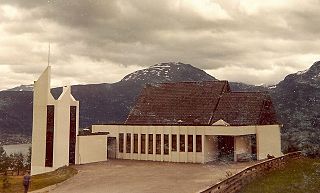
Nordsida Church is a parish church in Stryn Municipality in Sogn og Fjordane county, Norway. It is located in the village of Roset, on the northern shore of the Nordfjorden. The church is part of the Nordsida parish in the Nordfjord deanery in the Diocese of Bjørgvin of the Lutheran Church of Norway. The concrete church was built in 1973 by the architect Alf Apelseth. The church seats about 220 people.