Innvik (village)

Last updated
Innvik
Village
Norway Sogn og Fjordane location map.svg
Red pog.svg
Innvik
Location in Sogn og Fjordane county
Norway location map.svg
Red pog.svg
Innvik
Innvik (Norway)
Coordinates: 61°51′08″N06°36′54″E / 61.85222°N 6.61500°E / 61.85222; 6.61500 Coordinates: 61°51′08″N06°36′54″E / 61.85222°N 6.61500°E / 61.85222; 6.61500
Country Norway
Region Western Norway
County Sogn og Fjordane
District Nordfjord
Municipality Stryn Municipality
Area [1]
  Total 0.7 km2 (0.3 sq mi)
Elevation [2] 6 m (20 ft)
Population (2013) [1]
  Total 453
  Density 647/km2 (1,680/sq mi)
Time zone CET (UTC+01:00)
  Summer (DST) CEST (UTC+02:00)
Post Code6793 Innvik

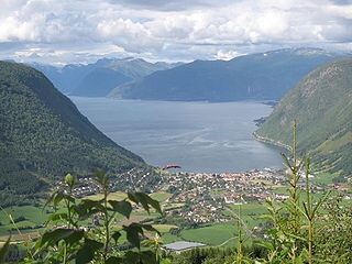
Innvik is a village in Stryn Municipality in Sogn og Fjordane county, Norway. The village is located on the southern shore of the Nordfjorden. The village is located about 15 kilometres (9.3 mi) west of the village of Olden and about 7 kilometres (4.3 mi) northeast of the village of Utvik. Directly across the fjord from Innvik lies the village of Roset. [3]

Sogn og Fjordane County (fylke) of Norway

Sogn og Fjordane is a county in western Norway, bordering Møre og Romsdal, Oppland, Buskerud, and Hordaland. The county administration is in the village of Hermansverk in Leikanger municipality. The largest town in the county is Førde.

Norway constitutional monarchy in Northern Europe

Norway, officially the Kingdom of Norway, is a Nordic country in Northwestern Europe whose territory comprises the western and northernmost portion of the Scandinavian Peninsula; the remote island of Jan Mayen and the archipelago of Svalbard are also part of the Kingdom of Norway. The Antarctic Peter I Island and the sub-Antarctic Bouvet Island are dependent territories and thus not considered part of the kingdom. Norway also lays claim to a section of Antarctica known as Queen Maud Land.

Nordfjorden (Sogn og Fjordane) fjord in Sogn og Fjordane, Norway

Nordfjorden is the sixth longest fjord in Norway and the second longest fjord in all of Sogn og Fjordane county. It flows through the municipalities of Stryn, Gloppen, Eid, Bremanger, and Vågsøy, and it is the central feature of the entire Nordfjord region which makes up the northern third of the county.

The village was the administrative centre of the old municipality of Innvik, which existed from 1838 until 1965. Innvik Church is located in the village. The 0.7-square-kilometre (170-acre) village has a population (2013) of 453, giving the village a population density of 647 inhabitants per square kilometre (1,680/sq mi). [1]

An administrative centre is a seat of regional administration or local government, or a county town, or the place where the central administration of a commune is located.

Innvik Former Municipality in Sogn og Fjordane, Norway

Innvik is a former municipality in Sogn og Fjordane county in Norway. Innvik is located in the present-day Stryn Municipality, encompassing about the western third of the present municipality. Innvik included both sides of the Nordfjorden, from Randabygda in the west to just west of the village of Stryn. It stretched from the border with Hornindal Municipality in the north, through the Oldedalen valley all the way to the Jostedalsbreen glacier in the south.

Innvik Church Church in Sogn og Fjordane, Norway

Innvik Church is a parish church in Stryn Municipality in Sogn og Fjordane county, Norway. It is located in the village of Innvik. The church is part of the Innvik parish in the Nordfjord deanery in the Diocese of Bjørgvin. There has been a church at Innvik since the Middle Ages. The original church was a stave church, but that church eventually needed to be replaced, and then the present church was built. The present church is a white, wooden, octagonal church that was built in 1824 by Elling Olsen Waldboe. The church seats about 350 people.

Name

The name comes from the old Innvik farm (Old Norse: Víkr), since Innvik Church is located there. The old name is identical with the word vík which means "inlet". Over time, the prefix inn- (meaning "inner") was added to distinguish the area from nearby Utvik (meaning "outer" Vik). The name Indviken or the more modern spelling Innvik has been in use since the 15th century. [3] [4]

Old Norse North Germanic language

Old Norse was a North Germanic language that was spoken by inhabitants of Scandinavia and their overseas settlements from about the 9th to the 13th century.

Inlet An indentation of a shoreline that often leads to an enclosed body of salt water, such as a sound, bay, lagoon, or marsh

An inlet is an indentation of a shoreline, usually long and narrow, such as a small bay or arm, that often leads to an enclosed body of salt water, such as a sound, bay, lagoon, or marsh.

Utvik Village in Western Norway, Norway

Utvik is a village in Stryn Municipality in Sogn og Fjordane county, Norway. The village is located on the southern shore of the Nordfjorden. The village lies about 7 kilometres (4.3 mi) southwest of the village of Innvik and about 10 kilometres (6.2 mi) north of the village of Byrkjelo. Utvik Church is located in this village. Historically, the village was an important trading post and ferry port with a regular route across the fjord. The ferry was stopped in 1936 when the new road was completed along the Nordfjorden connecting Utvik to the village of Stryn.

Related Research Articles

Leikanger Municipality in Sogn og Fjordane, Norway

Leikanger is a municipality in Sogn og Fjordane county, Norway. It is located on the northern shore of the Sognefjorden in the traditional district of Sogn. The administrative center is the village of Hermansverk, which is also the administrative center of Sogn og Fjordane county.

Hornindal Municipality in Sogn og Fjordane, Norway

Hornindal is a municipality in the county of Sogn og Fjordane, Norway. It is located in the traditional district of Nordfjord. The administrative centre of the municipality is the village of Grodås. The municipality sits at the eastern end of the lake Hornindalsvatnet, the deepest lake in Northern Europe. The rest of the lake lies inside neighboring Eid Municipality.

Stryn Municipality in Sogn og Fjordane, Norway

Stryn is a municipality in the county of Sogn og Fjordane, Norway. It is located in the traditional district of Nordfjord. The administrative center of the municipality is the village of Stryn. The municipality is located along the innermost part of the Nordfjorden. Some of the main villages in Stryn include Loen, Innvik, Utvik, Randabygda, Olden, and Flo.

Breim Former Municipality in Western Norway, Norway

Breim is a former municipality in Sogn og Fjordane county, Norway. It is part of the traditional district of Nordfjord in the eastern part of the present-day Gloppen Municipality. The municipality existed from 1886 until 1964 and the administrative center was the village of Reed.

Oppstrynsvatn lake in Stryn, Norway

Oppstrynsvatn is a lake in the municipality of Stryn in Sogn og Fjordane county, Norway. It is located about 8 kilometres (5.0 mi) east of the village of Stryn. The villages of Flo, Oppstryn, and Erdal are located on the shores of the lake.

Vikøyri Village in Western Norway, Norway

Vikøyri is the administrative center of the municipality of Vik in Sogn og Fjordane county, Norway. The village is located at the mouth of the Vikja river on the south shore of the Sognefjorden, roughly near the midpoint of Norway's longest fjord. The village lies along Norwegian National Road 13 which leads north to the ferry to Balestrand and south to the village of Vossevangen. The 1.26 square kilometres village of Vikøyri has a population (2013) of 1,195; giving the village a population density of 948 inhabitants per square kilometre (2,460/sq mi).

Olden, Norway Village in Western Norway, Norway

Olden is a village and urban area in the municipality of Stryn in Sogn og Fjordane county, Norway. Olden is located at the mouth of the Oldeelva river at the northern end of the Oldedalen valley on the southern shore of the Nordfjorden. The 0.57-square-kilometre (140-acre) village has a population (2013) of 498, giving the village a population density of 874 inhabitants per square kilometre (2,260/sq mi). Olden is located about 6 kilometres (3.7 mi) southwest of the village of Loen, about a 16 kilometres (9.9 mi) drive southeast of the municipal center of Stryn, and about 15 kilometres (9.3 mi) east of the village of Innvik.

Stryn (village) Village in Western Norway, Norway

Stryn is the administrative centre of Stryn Municipality in Sogn og Fjordane county, Norway. The village is located on the shore of a small bay off of the main Nordfjorden. The mouth of the river Stryneelva is in the village. The village sits about 3.5 kilometres (2.2 mi) west of the village of Nedstryn.

Roset, Sogn og Fjordane Village in Western Norway, Norway

Roset or Nordsida is a village in Stryn Municipality in Sogn og Fjordane county, Norway. The village is located on the northern shore of the Nordfjorden. The village is located about 15 kilometres (9.3 mi) east of the village of Randabygda and about 15 kilometres (9.3 mi) west of the village of Stryn. The village of Innvik lies directly across the Nordfjorden from Roset. Nordsida Church is located in Roset.

Nedstryn Village in Western Norway, Norway

Nedstryn is a village in Stryn Municipality in Sogn og Fjordane county, Norway. The village is located along the river Stryneelva, about 3.5 kilometres (2.2 mi) east of the village of Stryn and the same distance west of the large lake Oppstrynsvatnet. The small village is home to Nedstryn Church. The church serves all of the residents in the area surrounding the church, including the nearby village of Stryn and the areas north of the lake Oppstrynsvatnet including the village of Flo.

Utvik Church Church in Sogn og Fjordane, Norway

Utvik Church is a parish church in Stryn Municipality in Sogn og Fjordane county, Norway. It is located in the village of Utvik. The church is part of the Utvik parish in the Nordfjord deanery in the Diocese of Bjørgvin. The white wooden church was built in 1840 by the architect Hans Linstow. The church seats about 350 people.

Davik (village) Village in Western Norway, Norway

Davik is a village in Bremanger Municipality in Sogn og Fjordane county, Norway. The village is located on the southern shore of the Nordfjorden, about 11 kilometres (6.8 mi) west of the village of Isane and about 13 kilometres (8.1 mi) east of the village of Rugsund. The village of Kjølsdalen lies across the fjord from Davik. The population of the village was about 330 residents.

Eikefjord (village) Village in Western Norway, Norway

Eikefjord is a village in Flora Municipality in Sogn og Fjordane county, Norway. The village is located at the end of the Eikefjorden along the Norwegian National Road 5 highway. The town of Florø lies about 30 kilometres (19 mi) to the west and the village of Naustdal lies about 20 kilometres (12 mi) to the southeast (through the Naustdal Tunnel. The lake Endestadvatnet lies about 5 kilometres to the east. The villages of Nyttingnes and Steinhovden lie about 15 kilometres west of Eikefjord. The 0.4-square-kilometre village has a population of 368, giving the village a population density of 920 inhabitants per square kilometre.

References

  1. 1 2 3 Statistisk sentralbyrå (1 January 2013). "Urban settlements. Population and area, by municipality".
  2. "Innvik, Stryn" (in Norwegian). yr.no . Retrieved 2013-10-07.
  3. 1 2 "Innvik i Sogn og Fjordane" (in Norwegian). Store norske leksikon . Retrieved 2013-10-07.
  4. Rygh, Oluf (1919). Norske gaardnavne: Nordre Bergenhus amt (in Norwegian) (12 ed.). Kristiania, Norge: W. C. Fabritius & sønners bogtrikkeri. p. 485.