
A municipality is usually a single administrative division having corporate status and powers of self-government or jurisdiction as granted by national and regional laws to which it is subordinate.
Taiwan is divided into multi-layered statutory subdivisions. Due to the complex political status of Taiwan, there is a significant difference in the de jure system set out in the original constitution and the de facto system in use today.

Since 1 January 2023, there have been 342 regular municipalities and three special municipalities in the Netherlands. The latter is the status of three of the six island territories that make up the Dutch Caribbean. Municipalities are the second-level administrative division, or public bodies, in the Netherlands and are subdivisions of their respective provinces. Their duties are delegated to them by the central government and they are ruled by a municipal council that is elected every four years. Municipal mergers have reduced the total number of municipalities by two-thirds since the first official boundaries were created in the mid 19th century. Municipalities themselves are informally subdivided into districts and neighbourhoods for administrative and statistical purposes.

An unincorporated area is a region that is not governed by a local municipal corporation. There are many unincorporated communities and areas in the United States and Canada.

A city is one of the units of local government in the Philippines. All Philippine cities are chartered cities, whose existence as corporate and administrative entities is governed by their own specific municipal charters in addition to the Local Government Code of 1991, which specifies their administrative structure and powers. As of July 8, 2023, there are 149 cities.

Algeria, since December 18, 2019, is divided into 58 wilayas (provinces). Prior to December 18, 2019, there were 48 provinces. The 58 provinces are divided into 1,541 baladiyahs (municipalities). The name of a province is always that of its capital city.

Halifax is the capital and most populous municipality of the Canadian province of Nova Scotia, and the most populous municipality in Atlantic Canada. As of 2023, it is estimated that the population of the Halifax CMA was 518,711, with 348,634 people in its urban area. The regional municipality consists of four former municipalities that were amalgamated in 1996: Halifax, Dartmouth, Bedford, and Halifax County.

Båstad is a locality and the seat of Båstad Municipality, Scania County, Sweden, with approximately 5,000 permanent residents. It is however one of Sweden's most typical summer resorts. The population is presumably more than twice as large between April and September, and even larger during July. Its municipality follows a similar pattern: some 15,000 permanent residents, but more than 30,000 during July. Some villages within the municipality are almost empty during the winter, but have more than 2,000 "summer guests" during July. Torekov is a good example of this.
The regions of Iceland are eight areas of Iceland that roughly follow the arrangement of parliamentary constituencies as they were between 1959 and 2003. These regions are not incorporated polities but rather recognized groupings of municipalities. Iceland only has two levels of administration, the national government and 64 municipalities. The municipalities have organized themselves into eight regional associations and those boundaries are also recognized by Statistics Iceland to report statistics. Since 2014, police and commissioner (sýslumaður) districts have followed the eight region model with the exception that Vestmannaeyjar form a special district and are not part of the South region. The divisions of Iceland for the purposes of health care and district courts diverge more from the commonly used eight region model.

Municipalities are the lowest level of official territorial division in Germany. This can be the second, third, fourth or fifth level of territorial division, depending on the status of the municipality and the Land it is part of. The city-states Berlin and Hamburg are second-level divisions. A Gemeinde is one level lower in those states which also include Regierungsbezirke as an intermediate territorial division. The Gemeinde is one level higher if it is not part of a Gemeindeverband.

Kovin is a town and municipality located in the South Banat District of the autonomous province of Vojvodina, Serbia. The town has a population of 13,515, while the municipality has 33,722 inhabitants.

Mtskheta-Mtianeti is a region (Mkhare) in eastern Georgia comprising the town of Mtskheta, which serves as a regional capital, together with its district and the adjoining mountainous areas. The western part of the region, namely the entire Akhalgori Municipality, is controlled by breakaway South Ossetia since the 2008 Russo-Georgian War.
The Sangguniang Bayan is the local legislative branch of the municipal governments in the Philippines. It is responsible for passing ordinances and resolutions for the administration of a municipality. Its powers are defined by the Local Government Code, passed by Congress in 1991.

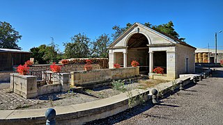
Étrabonne is a commune in the Doubs department in the Bourgogne-Franche-Comté region in eastern France.
Ercheu is a commune in the Somme department in Hauts-de-France in northern France.
Vaux-le-Moncelot is a commune in the Haute-Saône department in the region of Bourgogne-Franche-Comté in eastern France.
Dunavtsi is a town in northwestern Bulgaria, part of Vidin Municipality, Vidin Province. It lies in the northwestern Danubian Plain, in a small valley adjacent to the Danube River. As of December 2009, the town had a population of 2,743.
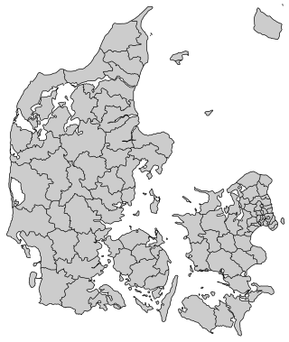
Denmark is divided into five regions, which contain 98 municipalities. The Capital Region has 29 municipalities, Southern Denmark 22, Central Denmark 19, Zealand 17 and North Denmark 11.
Lümanda-Kulli is a village in Saaremaa Parish, Saare County, in western Estonia.


