
The Union of Soviet Socialist Republics (USSR), commonly known as the Soviet Union, was a transcontinental country that spanned much of Eurasia from 1922 to 1991. It was the largest country in the world by area, extending across eleven time zones and sharing land borders with twelve countries. A successor state to the Russian Empire, the country was nominally organized as a federal union of fifteen national republics, the largest and most populous of which was the Russian SFSR; in practice, both its government and its economy were highly centralized until its final years. It was the world's third-most populous country and Europe's most populous country. As a one-party state governed by the Communist Party of the Soviet Union, it was a flagship communist state. Its capital as well as its largest city was Moscow. Other highly urbanized centers included Leningrad, Kiev, Tashkent, Baku, Kharkov, and Minsk.

Fort Novosel is a United States Army post located primarily in Dale County, Alabama, United States. It is named in honor of Chief Warrant Officer Michael J. Novosel, an Army aviator and Medal of Honor recipient. It was previously named for a Civil War officer, Confederate Colonel Edmund Rucker. The post is the primary flight training installation for U.S. Army Aviators and is home to the United States Army Aviation Center of Excellence (USAACE) and the United States Army Aviation Museum. Small sections of the post also lie in Coffee, Geneva, and Houston counties. Part of the Dale County section of the base is a census-designated place; its population was 4,636 at the 2010 census.

Bagram Airfield-BAF, also known as Bagram Air Base, is located 11 kilometres (6.8 mi) southeast of Charikar in the Parwan Province of Afghanistan. It is under the Afghan Ministry of Defense. Sitting on the site of the ancient Bagram at an elevation of 1,492 metres (4,895 ft) above sea level, the air base has two concrete runways. The main one measures 3,602 by 46 metres, capable of handling large military aircraft, including the Lockheed Martin C-5 Galaxy. The second runway measures 2,953 by 26 metres. The air base also has at least three large hangars, a control tower, numerous support buildings, and various housing areas. There are also more than 13 hectares of ramp space and five aircraft dispersal areas, with over 110 revetments.
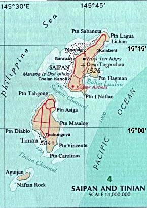
Tinian is one of the three principal islands of the Commonwealth of the Northern Mariana Islands (CNMI). Together with uninhabited neighboring Aguiguan, it forms Tinian Municipality, one of the four constituent municipalities of the Northern Marianas. Tinian's largest village is San Jose. Tinian is just south of the most inhabited island Saipan, but north of the populated Rota to the south. The island is home to many WW2 historical sites, cattle ranches, and beaches. There was a 5-star casino that operated from 1998 to 2015; remaining are other hotels/resorts and a golf course. The main access to Saipan is by a short airplane ride from the international airport, or by a charter boat.

Lazarevac is a municipality of the city of Belgrade. As of 2022, the town has a total population of 27,635 inhabitants, while the municipal area has a total of 55,146 inhabitants.

The 8th Guards Order of Lenin Combined Arms Army is an army of the Russian Ground Forces, headquartered in Novocherkassk, Rostov Oblast, within Russia′s Southern Military District, that was reinstated in 2017 as a successor to the 8th Guards Army of the Soviet Union's Red Army, which was formed during World War II and was disbanded in 1998 after being downsized into a corps. Military Unit в/ч 61877.

RAF Andover is a former Royal Flying Corps and Royal Air Force station in England, 2 miles (3.2 km) west of Andover, Hampshire. As well as RFC and RAF units, units of the Aviation Section, U.S. Signal Corps, Royal Canadian Air Force, United States Army Air Forces, and the Air Transport Auxiliary were also stationed at the airfield.

Tanauan, officially the Municipality of Tanauan, is a 2nd-class municipality in the province of Leyte, Philippines. According to the 2020 census, it has a population of 57,455 people.

Bleicherode is a town in the district of Nordhausen, in Thuringia, Germany. It is situated on the river Wipper, 17 km southwest of Nordhausen. On 1 December 2007, the former municipality Obergebra was incorporated by Bleicherode. The former municipalities Etzelsrode, Friedrichsthal, Kleinbodungen, Kraja, Hainrode, Nohra, Wipperdorf and Wolkramshausen were merged into Bleicherode in January 2019. Every Tuesday and Thursday, there is a market held at the Zierbrunnenplatz in the town.

Lenín Boltaire Moreno Garcés is a politician who served as the 46th president of Ecuador, from 2017 to 2021. Moreno was vice president from 2007 to 2013, serving under President Rafael Correa.

Nohra is a village and a former municipality in the district of Nordhausen, in Thuringia, Germany. As of 2018, Nohra had a population of 799.

Yeysk Airport is an airport located near the city of Yeysk, Russia.
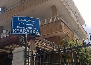
Kfaraakka also spelled Kferaakka is a village in the Koura District of Lebanon. It covers an area of 5.6 million square meters with an estimated population of 3,500. It had a population of 1,196 in 1953.

Nohra Puyana de Pastrana is the wife of the 30th president of Colombia, Andrés Pastrana, and served as First Lady of Colombia from 1998 to 2002.

Grammetal is a municipality in the Weimarer Land district, in Thuringia, Germany. It was created with effect from 31 December 2019 by the merger of the former municipalities of Bechstedtstraß, Daasdorf am Berge, Hopfgarten, Isseroda, Mönchenholzhausen, Niederzimmern, Nohra, Ottstedt am Berge and Troistedt, that had previously coöperated in the Verwaltungsgemeinschaft Grammetal. It takes its name from the river Gramme, that flows through the municipality.
Nohra was the first of the early Nazi concentration camps in Germany, established 3 March 1933 in a school at an airfield in Nohra. The camp was administered by the interior ministry of Thuringia. The inmates were exclusively communists and included half of the Communist party group in the Thuringian state parliament. Prisoners were not forced to work or systematically abused, but had to suffer from poor hygienic conditions and did not have beds. The camp was closed down again after a few months, and the building was demolished in the 1950s. A plaque commemorating the camp was installed in 1988 but taken down in 1990; as of 2023 there is no memorial board for the camp.

Columbia Field, originally Curtiss Field, is a former airfield near Valley Stream within the Town of Hempstead on Long Island, New York. Between 1929 and 1933 it was a public airfield named Curtiss Field after the Curtiss-Wright aircraft corporation that owned it. The public airfield closed after 1933, but aircraft continued to be manufactured there primarily by Columbia Aircraft Corporation, which gave the private airfield its name.


