Uzdowo

Last updated
Uzdowo
Village
Poland adm location map.svg
Red pog.svg
Uzdowo
Coordinates: 53°20′N20°6′E / 53.333°N 20.100°E / 53.333; 20.100
Country Flag of Poland.svg Poland
Voivodeship Warmian-Masurian
County Działdowo
Gmina Gmina Działdowo
Population 770

Uzdowo [uzˈdɔvɔ] (German : Usdau) [1] is a village in the administrative district of Gmina Działdowo, within Działdowo County, Warmian-Masurian Voivodeship, in northern Poland. [2] It lies approximately 13 kilometres (8 mi) north-west of Działdowo and 57 km (35 mi) south-west of the regional capital Olsztyn. It was formerly part of the German province of East Prussia.

German language West Germanic language

German is a West Germanic language that is mainly spoken in Central Europe. It is the most widely spoken and official or co-official language in Germany, Austria, Switzerland, South Tyrol (Italy), the German-speaking Community of Belgium, and Liechtenstein. It is also one of the three official languages of Luxembourg and a co-official language in the Opole Voivodeship in Poland. The languages which are most similar to German are the other members of the West Germanic language branch: Afrikaans, Dutch, English, the Frisian languages, Low German/Low Saxon, Luxembourgish, and Yiddish. There are also strong similarities in vocabulary with Danish, Norwegian and Swedish, although those belong to the North Germanic group. German is the second most widely spoken Germanic language, after English.

Village Small clustered human settlement smaller than a town

A village is a clustered human settlement or community, larger than a hamlet but smaller than a town, with a population ranging from a few hundred to a few thousand. Though villages are often located in rural areas, the term urban village is also applied to certain urban neighborhoods. Villages are normally permanent, with fixed dwellings; however, transient villages can occur. Further, the dwellings of a village are fairly close to one another, not scattered broadly over the landscape, as a dispersed settlement.

Gmina Działdowo is a rural gmina in Działdowo County, Warmian-Masurian Voivodeship, in northern Poland. Its seat is the town of Działdowo, although the town is not part of the territory of the gmina.

The village has a population of 770.

History

As a part of Prussia, Usdau entered the German Empire in 1871.

Prussia state in Central Europe between 1525–1947

Prussia was a historically prominent German state that originated in 1525 with a duchy centred on the region of Prussia on the southeast coast of the Baltic Sea. It was de facto dissolved by an emergency decree transferring powers of the Prussian government to German Chancellor Franz von Papen in 1932 and de jure by an Allied decree in 1947. For centuries, the House of Hohenzollern ruled Prussia, successfully expanding its size by way of an unusually well-organised and effective army. Prussia, with its capital in Königsberg and from 1701 in Berlin, decisively shaped the history of Germany.

German Empire empire in Central Europe between 1871–1918

The German Empire, also known as Imperial Germany, was the German nation state that existed from the unification of Germany in 1871 until the abdication of Kaiser Wilhelm II in 1918.

With the outbreak of the First World War and the August 1914 invasion of East Prussia by the Russian Empire, Usdau was occupied by units of the Imperial Russian Army. The town was recovered by the German 1st Division on the late morning of August 27 as the surviving occupiers withdrew. The town had been badly damaged by artillery fire and contained a large number of dead or injured Russian soldiers. [3]

Imperial Russian Army land armed force of the Russian Empire

The Imperial Russian Army was the land armed force of the Russian Empire, active from around 1721 to the Russian Revolution of 1917. In the early 1850s, the Russian army consisted of more than 900,000 regular soldiers and nearly 250,000 irregulars.

The 1st Division was a unit of the Prussian/German Army. It was formed in Königsberg in March 1816 as a Troop Brigade (Truppen-Brigade). It became the 1st Division on September 5, 1818. From the corps' formation in 1820, the division was subordinated in peacetime to I Army Corps. The 1st Division was disbanded in 1919, during the demobilization of the German Army after World War I.

Following the German defeat in the Second World War, Usdau and the surrounding area were ceded to Poland.

Poland Republic in Central Europe

Poland, officially the Republic of Poland, is a country located in Central Europe. It is divided into 16 administrative subdivisions, covering an area of 312,696 square kilometres (120,733 sq mi), and has a largely temperate seasonal climate. With a population of approximately 38.5 million people, Poland is the sixth most populous member state of the European Union. Poland's capital and largest metropolis is Warsaw. Other major cities include Kraków, Łódź, Wrocław, Poznań, Gdańsk, and Szczecin.

Related Research Articles

Warmian-Masurian Voivodeship Voivodeship in Poland

Warmian-Masurian Voivodeship or Warmia-Masuria Province or Warmia-Mazury Province, is a voivodeship (province) in northeastern Poland. Its capital and largest city is Olsztyn. The voivodeship has an area of 24,192 km2 (9,341 sq mi) and a population of 1,427,091.

Działdowo Place in Warmian-Masurian, Poland

Działdowopronounced [d͡ʑau̯ˈdɔvɔ] is a town in north-central Poland with 24,830 inhabitants (2006), the capital of Działdowo County. Situated in the Warmian-Masurian Voivodeship, Działdowo belonged previously to Ciechanów Voivodeship (1975–1998). The town is a major railroad junction connecting the capital city of Warsaw with Gdańsk and Olsztyn to the north.

Dąbrówno Village in Warmian-Masurian, Poland

Dąbrówno is a village and the seat of a gmina (municipality) in Ostróda County, Warmian-Masurian Voivodeship in northern Poland. It lies approximately 30 kilometres (19 mi) south of Ostróda and 50 km (31 mi) south-west of the regional capital Olsztyn.

Płośnica Village in Warmian-Masurian, Poland

Płośnica is a village in Działdowo County, Warmian-Masurian Voivodeship, in northern Poland. It is the seat of the gmina called Gmina Płośnica. It lies approximately 13 kilometres (8 mi) north-west of Działdowo and 65 km (40 mi) south-west of the regional capital Olsztyn.

Olsztynek Place in Warmian-Masurian, Poland

Olsztynek is a town in Olsztyn County, in Warmian-Masurian Voivodeship of Poland. It is the administrative seat of Gmina Olsztynek.

Susz Place in Warmian-Masurian, Poland

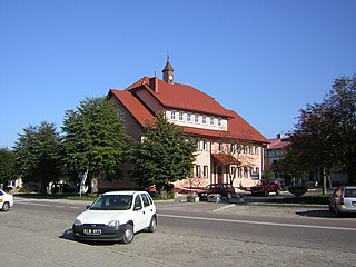
Susz is a town in Iława County, Warmian-Masurian Voivodeship, Poland, with 5,600 inhabitants (2004).

Ardapy Village in Warmian-Masurian, Poland

Ardapy is a village in the administrative district of Gmina Bartoszyce, within Bartoszyce County, Warmian-Masurian Voivodeship, in northern Poland, close to the border with the Kaliningrad Oblast of Russia. It lies approximately 3 kilometres (2 mi) south-west of Bartoszyce and 53 km (33 mi) north of the regional capital Olsztyn.

Gąsiorowo, Działdowo County Village in Warmian-Masurian, Poland

Gąsiorowo is a village in the administrative district of Gmina Działdowo, within Działdowo County, Warmian-Masurian Voivodeship, in northern Poland. It lies approximately 17 kilometres (11 mi) north of Działdowo and 50 km (31 mi) south-west of the regional capital Olsztyn.

Gnojno, Warmian-Masurian Voivodeship Village in Warmian-Masurian, Poland

Gnojno is a village in the administrative district of Gmina Działdowo, within Działdowo County, Warmian-Masurian Voivodeship, in northern Poland. It lies approximately 10 kilometres (6 mi) south-west of Działdowo and 74 km (46 mi) south of the regional capital Olsztyn.

Kramarzewo, Działdowo County Village in Warmian-Masurian, Poland

Kramarzewo is a village in the administrative district of Gmina Działdowo, within Działdowo County, Warmian-Masurian Voivodeship, in northern Poland. It lies approximately 12 kilometres (7 mi) north of Działdowo and 56 km (35 mi) south-west of the regional capital Olsztyn.

Myślęta Village in Warmian-Masurian, Poland

Myślęta is a village in the administrative district of Gmina Działdowo, within Działdowo County, Warmian-Masurian Voivodeship, in northern Poland. It lies approximately 14 kilometres (9 mi) north-west of Działdowo and 58 km (36 mi) south-west of the regional capital Olsztyn.

Mławka, Warmian-Masurian Voivodeship Village in Warmian-Masurian, Poland

Mławka is a village in the administrative district of Gmina Iłowo-Osada, within Działdowo County, Warmian-Masurian Voivodeship, in northern Poland. It lies approximately 5 kilometres (3 mi) south-east of Iłowo-Osada, 15 km (9 mi) south-east of Działdowo, and 73 km (45 mi) south of the regional capital Olsztyn.

Sochy, Warmian-Masurian Voivodeship Village in Lubelskie, Poland

Sochy is a village in the administrative district of Gmina Iłowo-Osada, within Działdowo County, Warmian-Masurian Voivodeship, in northern Poland. It lies approximately 3 kilometres (2 mi) east of Iłowo-Osada, 13 km (8 mi) south-east of Działdowo, and 70 km (43 mi) south of the regional capital Olsztyn.

Łężany, Warmian-Masurian Voivodeship Village in Warmian-Masurian, Poland

Łężany is a village in the administrative district of Gmina Reszel, within Kętrzyn County, Warmian-Masurian Voivodeship, in northern Poland. It lies approximately 10 kilometres (6 mi) south of Reszel, 21 km (13 mi) south-west of Kętrzyn, and 47 km (29 mi) north-east of the regional capital Olsztyn.

Naterki Village in Warmian-Masurian, Poland

Naterki is a village in the administrative district of Gmina Gietrzwałd, within Olsztyn County, Warmian-Masurian Voivodeship, in northern Poland. It lies approximately 10 kilometres (6 mi) east of Gietrzwałd and 11 km (7 mi) south-west of the regional capital Olsztyn.

Łutynówko Village in Warmian-Masurian, Poland

Łutynówko is a village in the administrative district of Gmina Olsztynek, within Olsztyn County, Warmian-Masurian Voivodeship, in northern Poland. It lies approximately 4 kilometres (2 mi) south-east of Olsztynek and 27 km (17 mi) south-west of the regional capital Olsztyn.

Borki Rozowskie Village in Warmian-Masurian, Poland

Borki Rozowskie is a village in the administrative district of Gmina Rozogi, within Szczytno County, Warmian-Masurian Voivodeship, in northern Poland. It lies approximately 13 kilometres (8 mi) south of Rozogi, 24 km (15 mi) east of Szczytno, and 62 km (39 mi) south-east of the regional capital Olsztyn.

Kusowo, West Pomeranian Voivodeship Village in West Pomeranian, Poland

Kusowo is a village in the administrative district of Gmina Szczecinek, within Szczecinek County, West Pomeranian Voivodeship, in north-western Poland. It lies approximately 13 kilometres (8 mi) north-west of Szczecinek and 137 km (85 mi) east of the regional capital Szczecin.

The 33rd Fusiliers "Count Roon" was a regiment of the Imperial German Army through the First World War.

Zawkrze

ZawkrzeZawkrze Land, is a small historic region of Poland (ziemia), located in northern Mazovia, along the border with Masuria. Its approximate area is 1,784 km2 (689 sq mi), and the population is about 114,000. Currently, Zawkrze has three towns, and more than 200 villages. Its name comes from the Wkra river – Zawkrze means the land behind the Wkra, from the perspective of Płock, historic capital of Mazovia. The largest town of the region is Mława, while historic capital of Zawkrze is Szreńsk.

References

  1. "Former Territory of Germany" (in German). 2017-11-08.
  2. "Central Statistical Office (GUS) - TERYT (National Register of Territorial Land Apportionment Journal)" (in Polish). 2008-06-01.
  3. Showalter, D.E. Tannenberg: Clash of Empires. Hamden: Archon, 1991. pp 249-254.


Coordinates: 53°20′N20°6′E / 53.333°N 20.100°E / 53.333; 20.100

Geographic coordinate system Coordinate system

A geographic coordinate system is a coordinate system that enables every location on Earth to be specified by a set of numbers, letters or symbols. The coordinates are often chosen such that one of the numbers represents a vertical position and two or three of the numbers represent a horizontal position; alternatively, a geographic position may be expressed in a combined three-dimensional Cartesian vector. A common choice of coordinates is latitude, longitude and elevation. To specify a location on a plane requires a map projection.