The European route E 22 is one of the longest European routes. It has a length of about 5,320 km (3,310 mi). Many of the E-roads have been extended into Asia since the year 2000; the E 22 was extended on 24 June 2002.
Albalate de las Nogueras is a municipality in Cuenca, Castile-La Mancha, Spain. It has a population of 356.

Tajná is a village and municipality in the Nitra District in western central Slovakia, in the Nitra Region.

Patchewollock is a town in north-west Victoria, Australia. At the 2016 census, Patchewollock had a population of 133.
Castiliscar is a municipality located in the province of Zaragoza, Aragon, Spain. According to the 2004 census (INE), the municipality has a population of 395 inhabitants.

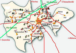
Argilos is a municipal department of the city of Kozani in northern Greece. Located south-west of the city centre, it had a population of 379 at the 2011 census. During the Ottoman empire it was called Geni-kioi. The modern name of the village comes from the argil soil with the red colour.
The Kara Dere is a river that empties into the Black Sea 20 miles east of Trabzon, Turkey. In ancient times it was known as the Hyssos or Hyssus.

Dərəgünəş is a village in the Shamakhi Rayon of Azerbaijan.

Dərə Zarat is a village in the Siazan Rayon of Azerbaijan. The village forms part of the municipality of Beşdam.

Górki is a village in the administrative district of Gmina Borowa, within Mielec County, Subcarpathian Voivodeship, in south-eastern Poland. It lies approximately 7 kilometres (4 mi) west of Borowa, 16 km (10 mi) north-west of Mielec, and 65 km (40 mi) north-west of the regional capital Rzeszów.

Ulejno is a village in the administrative district of Gmina Środa Wielkopolska, within Środa Wielkopolska County, Greater Poland Voivodeship, in west-central Poland. It lies approximately 7 kilometres (4 mi) north-east of Środa Wielkopolska and 34 km (21 mi) south-east of the regional capital Poznań.

Vallée-du-Ntem is a department of South Province in Cameroon. The department covers an area of 7,303 km² and as of 2005 had a total population of 79,182. The capital of the department lies at Ambam.
Dublovice is a village and municipality in Příbram District in the Central Bohemian Region of the Czech Republic.

M'Chedellah District is a district of Bouïra Province, Algeria.
M'Chedallah is a town and commune in Bouïra Province, Algeria. According to the 1998 census it has a population of 21,593.

Käesalu is a village in Lääne-Harju Parish, Harju County in northern Estonia.
Bogoroditsky, Bogoroditskaya, or Bogoroditskoye is the name of several rural localities in Russia.

Uzun Tappeh-ye Olya is a village in Qeshlaq-e Shomali Rural District, in the Central District of Parsabad County, Ardabil Province, Iran. At the 2006 census, its population was 241, in 49 families.
Polevoy, Polevaya, or Polevoye is the name of several rural localities in Russia.
Al-Marj is a Syrian village located in Muhambal Nahiyah in Ariha District, Idlib. According to the Syria Central Bureau of Statistics (CBS), Al-Marj had a population of 547 in the 2004 census.


