
Srikakulam district is one of the twenty-six districts of the Indian state of Andhra Pradesh, located in the Uttarandhra region of the state, with its headquarters located at Srikakulam. It is one of the six districts, located in the extreme northeastern direction of the state. It was formerly known as Chicacole, and was under Ganjam district till 1 April 1936, then merged under Vizagapatam district. Srikakulam district forms the core area of Kalinga where most of its historical capitals like Kalinganagari, pithunda, Dantapuram are located.

Srikakulam Lok Sabha constituency is one of the twenty-five lok sabha constituencies of Andhra Pradesh in India. It comprises seven assembly segments and belongs to Srikakulam district.
Amadalavalasa is a town in Srikakulam district of the Indian state of Andhra Pradesh. It is a municipality and also the mandal headquarters of Amadalavalasa mandal. The town is spread over an area of 19.65 km2 (7.59 sq mi), which is under the jurisdiction of Visakhapatnam Metropolitan Region Development Authority. Srikakulam Road railway station is situated at Amadalavalasa.

Nelli-marla is a census town in Vizianagaram district of the Indian state of Andhra Pradesh. It is in Nellimarla mandal of Vizianagaram revenue division.

The River Nagavali also known as Langulya is one of the main rivers of Southern Odisha and Andhra States in India, between Rushikulya and Godavari basins.
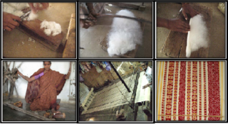
Ponduru is a census town in Srikakulam district of the Indian state of Andhra Pradesh. The town is the mandal headquarters of Ponduru mandal in Srikakulam revenue division. It falls under the Amadalavalasa Assembly Constituency and Srikakulam Loksabha Constituency.

Gara is a village in Srikakulam district of the Indian state of Andhra Pradesh. It is also the mandal head quarters of Gara Mandal, Srikakulam District, AP.

Hiramandalam is a census town in Srikakulam district of the Indian state of Andhra Pradesh. It is also the mandal headquarters of Hiramandalam mandal in Palakonda revenue division. BRR Project Located at Hiramandalam town. It is located 49 km towards North from District headquarters Srikakulam.
Kotturu is a village in Srikakulam district of the Indian state of Andhra Pradesh. It is located in Kothuru mandal of Palakonda revenue division.

Narasannapeta is a census town in Srikakulam district of the Indian state of Andhra Pradesh. It is the mandal headquarters of Narasannapeta mandal in Srikakulam revenue division. 43 villages are there under the administrative division of Narasannapeta.

Palakonda is a town in Parvathipuram Manyam district of the Indian state of Andhra Pradesh. It is a nagar panchayat and the mandal headquarters of Palakonda mandal in Palakonda revenue division

Pathapatnam is a town in Srikakulam district of the Indian state of Andhra Pradesh. It is located in Pathapatnam mandal of Tekkali revenue division. Telugu is the major spoken language in the town and in entire mandal. Pathapatnam is located on the border of Srikakulam district of Andhra Pradesh and Gajapati district of Odisha. Parlakhemundi, the headquarters of Gajapati District, can be considered as twin town of Pathapatnam because of its close proximity. It is located around 65 km from srikakulam. It was the old capital of Paralakhemundi Gajapati Maharajah of his erstwhile kingdom.
Saravakota is a village in Srikakulam district of the Indian state of Andhra Pradesh. It is located in Saravakota mandal of Palakonda revenue division.

Tekkali is a census town in Srikakulam district of the Indian state of Andhra Pradesh. It is the mandal headquarters of Tekkali mandal and Tekkali revenue division and is located at a distance of 51 km from the district headquarters.
Tilaru is a village located in Kotabommali mandal in Srikakulam district, Andhra Pradesh, India.
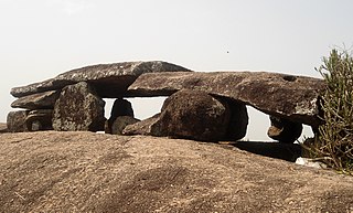
Kallepalli or Kallepalle is a village located around 5 kilometers from Srikakulam town in Andhra Pradesh, India.
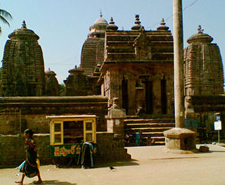
Mukhalingam, also known as Srimukhalingam or Mukhalinga, is a village panchayat in Jalumuru mandal of Srikakulam district in the Indian state of Andhra Pradesh. Historically known as Kalinganagari, Mukhalingam served as the capital of Eastern Ganga Dynasty from 6th century AD to 12th century AD. Emperor Sri Ananthavarma Chodaganga Devara conquered Utkala in 1122 AD and shifted the capital from Kalinganagari to Caudwara kataka
Haripuram is a village in Mandasa mandal of Srikakulam district, Andhra Pradesh, India.
Vunukuru Assembly constituency was an assembly constituency of the Andhra Pradesh Legislative Assembly, India. It was one of ten constituencies in Srikakulam district.
Jarjangi is a Panchayath village in Kotabommali mandal, Srikakulam district, in the Indian state of Andhra Pradesh. The Postal Index Code of this village is 532195.
