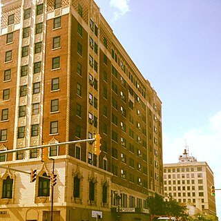
Gary is a city in Lake County, Indiana, United States, historically dominated by major industrial activity. The city is located along the southern shore of Lake Michigan about 25 miles (40 km) from downtown Chicago, Illinois. Gary is adjacent to the Indiana Dunes National Park, and within the Chicago metropolitan area.

Honolulu is the capital and largest city of the U.S. state of Hawaii, which is located in the Pacific Ocean. It is an unincorporated county seat of the consolidated City and County of Honolulu, situated along the southwest coast of the island of Oʻahu, and is the westernmost and southernmost major U.S. city. Honolulu is Hawaii's main gateway to the world. It is also a major hub for business, finance, hospitality, and military defense in both the state and Oceania. The city is characterized by a mix of various Asian, Western, and Pacific cultures, as reflected in its diverse demography, cuisine, and traditions.

Alameda County is located in the state of California in the United States. As of the 2020 census, the population was 1,682,353, making it the 7th-most populous county in the state and 21st most populous nationally. The county seat is Oakland. Alameda County is in the San Francisco Bay Area, occupying much of the East Bay region.

Tinley Park is a village in Cook County, Illinois, United States, with a small portion in Will County. Per the 2020 census, the population was 55,971. It is one of the fastest growing suburbs southwest of Chicago. In 2009, Tinley Park was selected by BusinessWeek as the best place to raise a family in America. In 2017, Tinley Park was listed as one of the 50 safest cities in America. Tinley Park is a suburb of Chicago. The village has a park in Brookside Glen called Lake of the Glens Park.

Medicine Hat is a city in southeast Alberta, Canada. It is located along the South Saskatchewan River. It is approximately 169 km (105 mi) east of Lethbridge and 295 km (183 mi) southeast of Calgary. This city and the adjacent Town of Redcliff to the northwest are within Cypress County. Medicine Hat was the sixth-largest city in Alberta in 2016 with a population of 63,230. It is also the sunniest place in Canada according to Environment and Climate Change Canada, averaging 2,544 hours of sunshine a year.

Kasaragod, Or Casrod (in Tulu, formerly known in English as Kassergode, and Malayalam as Kanhirakode, is a municipal town and administrative headquarters of Kasaragod district in the state of Kerala, India. Established in 1966, Kasaragod was the first municipal town in the district. It is the northernmost district of Kerala and is also known as Saptha Bhasha Sangama Bhoomi.

Palakkad District, in the southeastern part of the former Malabar district, is one of the 14 districts of the Indian state of Kerala. It is located right in the middle of the state. Also, it is the largest district in Kerala since 2006. The city of Palakkad is the district headquarters. Palakkad is bordered on the northwest by the Malappuram District, on the southwest by the Thrissur District, on the northeast by Nilgiris District, and on the east by Coimbatore district of Tamil Nadu. The district is nicknamed "the granary of Kerala". Palakkad is the gateway to Kerala due to the presence of the Palakkad Gap, in the Western Ghats. The 2,383 m high Anginda peak, which is situated in the border of Palakkad district, Nilgiris district, and Malappuram district, in Silent Valley National Park, is the highest point of elevation in Palakkad district. Palakkad city is located just 50 km away from Coimbatore, a major city in Tamil Nadu state.

Lucknow district is a district located in the state of Uttar Pradesh in northern India. The city of Lucknow is the district headquarters and the district is part of Lucknow Division. It also is the capital of Uttar Pradesh Lucknow is Bounded on the east by Barabanki district, on the west by Unnao and Hardoi districts, on the south by Raebareli district and in the north by Sitapur district.
Mannarkkad, formerly known as Mannarghat, is a municipal town in Palakkad district of the Indian state of Kerala. The Silent Valley National Park and the Attappadi Reserve Forest are located in Mannarkkad Taluk. Mannarkkad is situated 36 km away from district headquarters Palakkad on Palakkad-Kozhikode National Highway.

Kottayam, IPA: [koːʈːɐjɐm] is a city in the Indian state of Kerala. Flanked by the Western Ghats on the east and the Vembanad Lake and paddy fields of Kuttanad on the west, Kottayam is a place that is known for extraordinary qualities. It is the district headquarters of Kottayam district, located in south-west Kerala. Kottayam is located in the basin of the Meenachil River at an average elevation of 3 metres (9.8 ft) above sea level, and has a moderate climate. It is located approximately 155 kilometres (96 mi) north of the state capital Thiruvananthapuram.
Haldibari is a city and a municipality in the Mekhliganj subdivision of the Cooch Behar district in the Indian state of West Bengal.

Hindupur is a city in Sri Sathya Sai district of the Indian state of Andhra Pradesh. It is located at the edge of the Andhra–Karnataka border and is the headquarters of Hindupur mandal. Hindupur was biggest town in newly formed District Sri Sathya Sai. It is located about 67 km from district headquarters Puttaparthi, 100 km from Bengaluru the capital of Karnataka, 95 km From Kadiri.
Surendranagar Dudhrej wadhwan is a municipality in Surendranagar district in the Indian state of Gujarat. mainly Dudhrej municipality is directly connected with Wadhwan city and Wadhwan municipality.

Haringhata is a town and a municipality of the Nadia district in the Indian state of West Bengal.

Kasaragod is one of the 14 districts in the southern Indian state of Kerala. Its northern border Thalappady is located just 10 km south to Ullal, which is the southernmost portion of the major port city Mangalore, on the southwestern Malabar coast of India.
Dhavaleshwar is a village in the southern state of Karnataka, India. It is located in the Mahalingpur taluk of Bagalkot district in Karnataka. Dhavaleshwar is located on the bank of Ghataprabha river. The river bifurcates the Belgaum and Bagalkot districts. Just on the other side of the river, there is one more village which, is also known as Dhavaleshwar. This Dhavaleshwar belongs to Gokak Taluk of Belgaum district. Many politicians promised to build a bridge between both villages, but no one has initiated. The villagers grow sugar cane, which is the source of their income.

Bhagipur is a village in Unchahar block of Raebareli district, Uttar Pradesh, India. It is located 34 km from Raebareli, the district headquarters. As of 2011, it has a population of 446 people, in 89 households.
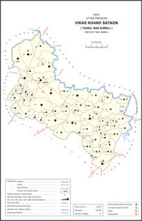
Garhi Dularai is a village located in Sataon block of Rae Bareli district, Uttar Pradesh, India. It is located 24 km from Raebareli, the district headquarters. As of 2011, its population is 1,300, in 232 households. It has one primary school and no healthcare facilities.
Paharpur Khera is a village located in Sataon block of Rae Bareli district, Uttar Pradesh, India. It is located 11 km from Raebareli, the district headquarters. As of 2011, its population is 632, in 112 households. It has one primary school and no healthcare facilities.

Aunanis is a village in Salon block of Rae Bareli district, Uttar Pradesh, India. It is located 2 km from Salon, the block and tehsil headquarters. As of 2011, Aunanis has a population of 1,115 people, in 209 households. It has one primary school and no healthcare facilities and is located on major district roads. It hosts neither a permanent market nor a periodic haat.
