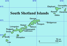
Kurilo Point is a sharp ice-free point on the southeast coast of Snow Island in the South Shetland Islands, Antarctica projecting 200 m into Bransfield Strait. Situated 3.1 km southwest of President Head and 2.3 km north of Hall Peninsula.

Chichil Point is the rocky point on the southwest coast of Clarence Island in the South Shetland Islands, Antarctica forming the west extremity of the island.

Soyka Saddle is the ice-covered saddle of elevation 1250 m connecting Ravelin Ridge and Urda Ridge on Clarence Island in the South Shetland Islands, Antarctica. It is situated between Mount Llana on the southwest and Jerez Peak on the north-northeast, and surmounts Highton Glacier to the east.

Urda Ridge is the mostly ice-covered ridge occupying the interior of southern Clarence Island in the South Shetland Islands, Antarctica. It extends 8 km in north-northeast to south-southwest direction and 9 km in west-northwest to east-southeast direction, rising to 1950 m at the island’s summit Mount Irving, and is connected to Ravelin Ridge to the north by Soyka Saddle. The southeast slopes of the feature are drained by Dobrodan and Highton Glaciers, and its northwest slopes — by Skaplizo, Giridava and Bersame Glaciers. Urda is a Thracian place name from Southern Bulgaria.

Skaplizo Glacier is 2 nautical miles long and 0.8 nautical miles wide glacier on the west side of Urda Ridge on Clarence Island in the South Shetland Islands, Antarctica situated south of Giridava Glacier. It drains the slopes of Mount Irving and Duclos-Guyot Bluff, flows west-northwestwards and enters the Southern Ocean northeast of Chichil Point.

Dobrodan Glacier is the 3.4 km long and 1.2 km wide glacier on the east side of Urda Ridge on Clarence Island in the South Shetland Islands, Antarctica situated south of Highton Glacier. It drains the slopes of Mount Irving and Duclos-Guyot Bluff, flows northeastwards and enters the Southern Ocean south of Lebed Point.

Giridava Glacier is 1.5 nautical miles long and 0.6 nautical miles wide glacier on the west side of Urda Ridge on Clarence Island in the South Shetland Islands, Antarctica situated north of Skaplizo Glacier and southwest of Bersame Glacier. It drains the slopes of Mount Irving, flows northwestwards and enters Chinstrap Cove east of Vaglen Point.

Mount Llana is the ice-covered peak rising to 1300 m at the north extremity of Urda Ridge on Clarence Island in the South Shetland Islands, Antarctica. It is connected to Jerez Peak by Soyka Saddle, and surmounts Bersame Glacier to the west and Highton Glacier to the east.

Bersame Glacier is the 2.4 km long and 1.5 km wide glacier on the west side of Urda Ridge on Clarence Island in the South Shetland Islands, Antarctica situated northeast of Giridava Glacier. It drains the slopes of Mount Llana, flows northwestwards and enters the Southern Ocean northeast of the terminus of Giridava Glacier.

Lebed Point is the rocky point on the south side of the entrance to Istros Bay on the east coast of Clarence Island in the South Shetland Islands, Antarctica.

Istros Bay is the 3.2 km wide bay indenting for 1.4 km the east coast of Clarence Island in the South Shetland Islands, Antarctica. It is entered north of Lebed Point and south of Sugarloaf Island, and has its head fed by Highton Glacier. Istros is the ancient name for the lower Danube River.

Jerez Peak is the ice-covered peak rising to 1400 m at the south extremity of Ravelin Ridge on Clarence Island in the South Shetland Islands, Antarctica. It is connected to Mount Llana by Soyka Saddle, and surmounts Treskavets Glacier to the northeast and Highton Glacier to the southeast.

Gesha Point is the small point on the east coast of Clarence Island in the South Shetland Islands, Antarctica separating the glacier termini of Orcho Glacier to the north and Treskavets Glacier to the south.

Treskavets Glacier is 1.3 nautical miles long and 0.8 nautical miles wide glacier on the east side of Ravelin Ridge on Clarence Island in the South Shetland Islands, Antarctica situated north of Highton Glacier and south of Orcho Glacier. It drains the slopes of Jerez Peak, flows northeastwards and enters the Southern Ocean south of Gesha Point.

Orcho Glacier is 1.1 nautical miles long and 1 nautical mile wide glacier on the east side of Ravelin Ridge on Clarence Island in the South Shetland Islands, Antarctica situated north of Treskavets Glacier and south-southwest of Banari Glacier. It flows eastwards and enters the Southern Ocean north of Gesha Point.

Ilyo Point (Bulgarian: нос Ильо, ‘Nos Ilyo’ \'nos 'i-lyo\ is the narrow rocky point projecting 600 m east-northeastwards from the east coast of Clarence Island in the South Shetland Islands, Antarctica. It forms the south side of the entrance to Smith Cove.

Kakrina Point (Bulgarian: нос Къкрина, ‘Nos Kakrina’ \'nos 'k&-kri-na\ is the rock-tipped point projecting 400 m south-southeastwards from the east coast of Clarence Island in the South Shetland Islands, Antarctica. It forms the north side of the entrance to Smith Cove.

Smith Cove is the 1.17 km wide cove indenting for 1.33 km the east coast of Clarence Island in the South Shetland Islands, Antarctica. It is entered north of Ilyo Point and south of Kakrina Point, and has its head fed by Banari Glacier.

Sintika Cove is the 4 km wide cove indenting for 2.35 km the southeast coast of Elephant Island in the South Shetland Islands, Antarctica. It is entered north of Endurance Point and south of the end of Endurance Glacier, and surmounted by Mount Elder on the southwest. The feature was formed as a result of the retreat of Endurance Glacier in the first decade of 21st century.


