The music of Bulgaria refers to all forms of music associated with the country of Bulgaria, including classical, folk, popular music, and other forms.

Haskovo is a city in the region of Northern Thrace in southern Bulgaria and the administrative centre of the Haskovo Province, not far from the borders with Greece and Turkey. According to Operative Program Regional Development of Bulgaria, the urban area of Haskovo is the seventh largest in Bulgaria and has a population of 184,731 inhabitants. Haskovo has a population of 64,564 as of 2022, making it Bulgaria's 12th largest city.

The provinces of Bulgaria are the first-level administrative subdivisions of the country.

Blagoevgrad Province, also known as Pirin Macedonia or Bulgarian Macedonia, is a province (oblast) of southwestern Bulgaria. It borders four other Bulgarian provinces to the north and east, the Greek region of Macedonia to the south, and North Macedonia to the west. The province has 14 municipalities with 12 towns. Its principal city is Blagoevgrad, while other significant towns include Bansko, Gotse Delchev, Melnik, Petrich, Razlog, Sandanski, and Simitli.

Kardzhali Province is a province of southern Bulgaria, neighbouring Greece with the Greek regional units of Xanthi, Rhodope, and Evros to the south and east. It is 3209.1 km2 in area. Its main city is Kardzhali. It is Bulgaria's southernmost province.

Haskovo Province is a province in southern Bulgaria, neighbouring Greece and Turkey to the southeast, comprising parts of the Thracian valley along the river Maritsa. It is named after its administrative and industrial centre: the city of Haskovo. The province has a territory of 5,533.3 km2 (2,136.4 sq mi) that is divided into 11 municipalities with a total population, as of December 2009, of 256,408 inhabitants.

Gabrovo Province is a small province lying at the geographical centre of Bulgaria. It is named after its main town - Gabrovo. In 2009 the total population of the area was 130,001.
Montana Province is a province in northwestern Bulgaria, bordering Serbia in the southwest and Romania in the north. It spreads its area between the Danube river and the Balkan Mountains. As of February 2011, the province had a population of 148,098, on territory of 3,635.5 km2 (1,403.7 sq mi). It was named after its administrative centre the city of Montana.

Radomir is a town in the Radomir Municipality in the Pernik Province of Bulgaria.

Sredets is a town in Burgas Province in southeastern Bulgaria. It is located near Lake Mandrensko and the northern slopes of Strandzha. Sredets is the administrative centre of Sredets Municipality.
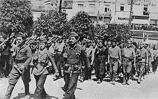
The 1944 Bulgarian coup d'état, also known as the 9 September coup d'état, was a coup that overthrew the government of Kingdom of Bulgaria carried out on the eve of 9 September 1944. During the People's Republic of Bulgaria it was called using the propaganda term People's Uprising of 9 September – on the grounds of the broad unrest and Socialist Revolution – as it was a turning point politically and the beginning of radical reforms towards Soviet-style socialism.
The dialects of Macedonian comprise the Slavic dialects spoken in the Republic of North Macedonia as well as some varieties spoken in the wider geographic region of Macedonia. They are part of the dialect continuum of South Slavic languages that joins Macedonian with Bulgarian to the east and Torlakian to the north into the group of the Eastern South Slavic languages. The precise delimitation between these languages is fleeting and controversial.
Tervel is a town in northeastern Bulgaria, part of Dobrich Province. It is the administrative centre of Tervel Municipality, which lies in the westernmost part of the province. As of December 2009, the town had a population of 6,667.

Strezimirovci is a divided village in easternmost Serbia and westernmost Bulgaria. The Bulgarian half of the village is part of Tran Municipality, Pernik Province, whereas the Serbian part belongs to Surdulica municipality, Pčinja District. The village has a border checkpoint, and its residents on either side of the border are mostly Bulgarian; however, its division has caused its population to decrease more than tenfold. It lies in the geographic region of Znepolje (Znepolјe), at 42°48′N22°26′E, in a valley along the Jerma River, 830 metres above mean sea level.

Soyka Saddle is the ice-covered saddle of elevation 1250 m connecting Ravelin Ridge and Urda Ridge on Clarence Island in the South Shetland Islands, Antarctica. It is situated between Mount Llana on the southwest and Jerez Peak on the north-northeast, and surmounts Highton Glacier to the east.
Giridava Glacier is 1.5 nautical miles long and 0.6 nautical miles wide glacier on the west side of Urda Ridge on Clarence Island in the South Shetland Islands, Antarctica situated north of Skaplizo Glacier and southwest of Bersame Glacier. It drains the slopes of Mount Irving, flows northwestwards and enters Chinstrap Cove east of Vaglen Point.
Vaglen Point is the rock-tipped point on the southwest side of the entrance to Chinstrap Cove on the northwest coast of Clarence Island in the South Shetland Islands, Antarctica.
Eik or Eig is a village in Kristiansand municipality in Agder county, Norway. The village is located on the south side of the European route E39 highway between the villages of Lunde to the west, Tangvall to the east, and Høllen to the south. The main residential neighborhood in the village is called Eikeheia. Vaglen Beach is located just to the south of the village. The village is considered to the part of the greater Søgne urban area, so its individual population statistics are not tracked by Statistics Norway.

