This is a list of the extreme points of San Marino: the points that are farther north, south, east or west than any other location.

Sinemorets is a village and seaside resort on the Black Sea coast of Bulgaria, located in the very southeast of the country close to the border with Turkey, where the river Veleka flows into the sea. Sinemorets is part of Tsarevo Municipality, Burgas Province, and has a population of 216 as of September 2005. It is situated in Strandzha Nature Park. Its coordinates are 42°4′N27°59′E.

Rakitovo is a town in the Pazardzhik Province, Bulgaria. As of 2005 the population is 8 952. It is located in the northern part of the Rhodopi mountains at 12 km to the east of Velingrad and 7 km to the southwest of the Batak Reservoir. There is timber industry in the town. People from the region grow crops, lavender, potatoes and barley.
Fanes is a village in the northeast part of Rhodes. The main village is situated around 1 km inland. Fanes has had extensive farm fields, near the coast and along the adjacent hills. It also has a small natural bay which was refitted as a yacht port in the 1990s. Since 1998, Fanes has formed part of the Municipality of Kameiros (Kamiros) — named after the ancient Doric city.

Ivanovo is a village in northeastern Bulgaria, part of Rousse Province. It is the administrative centre of Ivanovo Municipality, which lies in the central part of Rousse Province.
Kaynardzha is a village in northeastern Bulgaria, part of Silistra Province. It is the administrative centre of Kaynardzha Municipality, which lies in the easternmost part of Silistra Province, in the historical region of Southern Dobruja, close to the Romanian border.
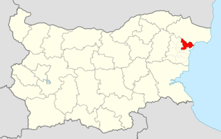
Dalgopol is a town in northeastern Bulgaria, part of Varna Province. It is the administrative centre of Dalgopol Municipality, which lies in the southwestern part of the Province. As of December 2009, the town has a population of 4,829 inhabitants.
Allela is a village and rural commune in Niger.
Plenimir is a village in General Toshevo Municipality, Dobrich Province, in northeastern Bulgaria.
Balaleya is a village in Dryanovo Municipality, in Gabrovo Province, in northern central Bulgaria.
Ganchovets is a village in Dryanovo Municipality, Gabrovo Province, in northern central Bulgaria.
Genya is a village in Dryanovo Municipality, in Gabrovo Province, in northern central Bulgaria.
Gesha is a village in Dryanovo Municipality, in Gabrovo Province, in northern central Bulgaria.
Karaivantsa is a village in Dryanovo Municipality, in Gabrovo Province, in northern central Bulgaria.

Družiniće is a village in the municipality of Sjenica, Serbia. According to the 2002 census, the village has a population of 19 people.
Lyuben Karavelovo is a village in Aksakovo Municipality, in Varna Province, Bulgaria.
Strazhnitsa is a village in Chernoochene Municipality, in Kardzhali Province, in southern-central Bulgaria. It covers an area of 2.155 square kilometres and as of 2007 it had a population of 183 people.
Izvornik is a village in Valchi Dol Municipality, Varna Province, Bulgaria.
Pomezhdin is a village in Georgi Damyanovo Municipality, Montana Province, north-western Bulgaria.
Kiselevo is a village in Brusartsi Municipality, Montana Province, north-western Bulgaria.