Kumanovo, Bulgaria

Last updated
Kumanovo
Village
Country Flag of Bulgaria.svg  Bulgaria
Province Varna Province
Municipality Aksakovo
Elevation 309 m (1,014 ft)
Time zone EET (UTC+2)
  Summer (DST) EEST (UTC+3)

Kumanovo is a village in Aksakovo Municipality, in Varna Province, Bulgaria. [1]

Aksakovo Municipality Municipality in Varna, Bulgaria

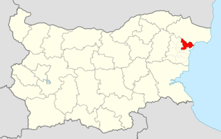
Aksakovo Municipality is a municipality (obshtina) in Varna Province, Northeastern Bulgaria, located near the Bulgarian Black Sea Coast. It is named after its administrative centre – the town of Aksakovo.

Varna Province Province in Bulgaria

Varna Province is a province in eastern Bulgaria, onе of the 28 Bulgarian provinces. It comprises 12 municipalities with a population, in April 2016, of 494,216 inhabitants. The province is named after its administrative centre, Varna.

Bulgaria country in Southeast Europe

Bulgaria, officially the Republic of Bulgaria, is a country in Southeast Europe. It is bordered by Romania to the north, Serbia and North Macedonia to the west, Greece and Turkey to the south, and the Black Sea to the east. The capital and largest city is Sofia; other major cities are Plovdiv, Varna and Burgas. With a territory of 110,994 square kilometres (42,855 sq mi), Bulgaria is Europe's 16th-largest country.

Kumanovo Peak on Oscar II Coast in Graham Land, Antarctica is named after the village.

Kumanovo Peak

Kumanovo Peak is the rocky, partly ice-free peak rising to 1050 m in Ivanili Heights on Oscar II Coast in Graham Land. It surmounts Rogosh Glacier to the northeast and east. The feature is named after the settlement of Kumanovo in Northeastern Bulgaria.

Oscar II Coast coast in Graham Land

Oscar II Coast is that portion of the east coast of the Antarctic Peninsula between Cape Fairweather to the north, and Cape Alexander to the south. Discovered in 1893 by Captain C.A. Larsen, who named it for King Oscar II of Norway and Sweden. To the north of this coast is Nordenskjöld Coast.

Graham Land geographical object

Graham Land is the portion of the Antarctic Peninsula that lies north of a line joining Cape Jeremy and Cape Agassiz. This description of Graham Land is consistent with the 1964 agreement between the British Antarctic Place-names Committee and the US Advisory Committee on Antarctic Names, in which the name "Antarctic Peninsula" was approved for the major peninsula of Antarctica, and the names Graham Land and Palmer Land for the northern and southern portions, respectively. The line dividing them is roughly 69 degrees south.

Related Research Articles

Iskar (town) Place in Pleven, Bulgaria

Iskar is a town in central northern Bulgaria, part of Pleven Province. It is the administrative centre of Iskar Municipality, which lies in the western part of the Province. The town of Iskar is located in the central Danubian Plain, near the Iskar River, 18 kilometres from Knezha and 32 kilometres from the provincial capital of Pleven. As of December 2009, the town has a population of 3,622 inhabitants.

Vetovo Place in Rousse, Bulgaria

Vetovo is a town in northeastern Bulgaria, part of Ruse Province. It is the administrative centre of Vetovo Municipality, which lies in the eastern part of the area, and ranks third in population in the province after Ruse and Byala. The town is located 40 kilometres away from the provincial capital - Ruse. As of December 2009, Vetovo has a population of 4,777 inhabitants.

Venets, Shumen Province Place in Shumen, Bulgaria

Venets is a village in northeastern Bulgaria, part of Shumen Province. It is the administrative centre of the homonymous Venets Municipality, which lies in the northwestern part of Shumen Province. The Venets Transmitter built in 1975 with the tallest radio mast in the country as well and the most powerful TV transmitter is located nearby.

Lipie, Pajęczno County Village in Łódź, Poland

Lipie is a village in the administrative district of Gmina Kiełczygłów, within Pajęczno County, Łódź Voivodeship, in central Poland. It lies approximately 5 kilometres (3 mi) north-west of Kiełczygłów, 14 km (9 mi) north of Pajęczno, and 69 km (43 mi) south-west of the regional capital Łódź.

Gabrovnitsa is a village in northwestern Bulgaria. It is located in the municipality of Montana in the Montana Province, 13 kilometres (8.1 mi) from the district center.

Bilka is a village in Ruen Municipality, in Burgas Province, in southeastern Bulgaria.

Karavelyovo is a village in Ruen Municipality, in Burgas Province, in southeastern Bulgaria.

Polkovnik Sveshtarovo is a village in the municipality of Dobrichka, in Dobrich Province, in northeastern Bulgaria.

Popgrigorovo is a village in the municipality of Dobrichka, in Dobrich Province, in northeastern Bulgaria.

Rositsa is a village in General Toshevo Municipality, Dobrich Province, in northeastern Bulgaria.

Zograf, Bulgaria is a village in General Toshevo Municipality, Dobrich Province, northeastern Bulgaria.

Krupen is a village in Kavarna Municipality, Dobrich Province, northeastern Bulgaria.

Travnik is a village in Kavarna Municipality, Dobrich Province, northeastern Bulgaria.

Topola is a village in Kavarna Municipality, Dobrich Province, northeastern Bulgaria.

Koriten is a village in the municipality of Krushari, in Dobrich Province, in northeastern Bulgaria.

Banari is a village in Dryanovo Municipality, in Gabrovo Province, in northern central Bulgaria.

Damyanovo is a village in the municipality of Sevlievo, in Gabrovo Province, in northern central Bulgaria.

Gornje Leviće Village in Rasina District, Serbia

Gornje Leviće is a village in the municipality of Brus, Serbia. According to the 2002 census, the village has a population of 138 people.

Dobrogled is a village in Aksakovo Municipality, in Varna Province, Bulgaria.

Tsareva Livada is a village in the municipality of Dryanovo, in Gabrovo Province, in northern central Bulgaria.

References

  1. Guide Bulgaria, Accessed 4 October 2011

Coordinates: 43°16′N27°56′E / 43.267°N 27.933°E / 43.267; 27.933

Geographic coordinate system Coordinate system

A geographic coordinate system is a coordinate system that enables every location on Earth to be specified by a set of numbers, letters or symbols. The coordinates are often chosen such that one of the numbers represents a vertical position and two or three of the numbers represent a horizontal position; alternatively, a geographic position may be expressed in a combined three-dimensional Cartesian vector. A common choice of coordinates is latitude, longitude and elevation. To specify a location on a plane requires a map projection.